

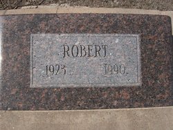
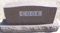
Robert Donald Cook
| Birth | : | 18 Mar 1923 Saint Francis, Cheyenne County, Kansas, USA |
| Death | : | 30 Mar 1990 Saint Francis, Cheyenne County, Kansas, USA |
| Burial | : | Vernon Grove Cemetery, Milford, Worcester County, USA |
| Coordinate | : | 42.1292000, -71.5124969 |
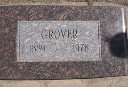
| Description | : | Robert Donald Cook was born near St. Francis, Kan. in the Neville neighborhood on March 18, 1923. He was the oldest child of Grover and Emma Cook. Although born handicapped, he was mechanically inclined. In his youger days he could keep the combine running when his dad left for the day at harvest time. He also drove the tractor when farming the land. He always had difficulty walking and had been confined to a wheelchair for many years. In later years he lost the use of his hands, but in spite of all this, he still... Read More |
frequently asked questions (FAQ):
-
Where is Robert Donald Cook's memorial?
Robert Donald Cook's memorial is located at: Vernon Grove Cemetery, Milford, Worcester County, USA.
-
When did Robert Donald Cook death?
Robert Donald Cook death on 30 Mar 1990 in Saint Francis, Cheyenne County, Kansas, USA
-
Where are the coordinates of the Robert Donald Cook's memorial?
Latitude: 42.1292000
Longitude: -71.5124969
Family Members:
Parent

Siblings

Flowers:


Nearby Cemetories:
1. Vernon Grove Cemetery
Milford, Worcester County, USA
Coordinate: 42.1292000, -71.5124969
2. South Hopedale Cemetery
Hopedale, Worcester County, USA
Coordinate: 42.1114000, -71.5139000
3. Hopedale Village Cemetery
Hopedale, Worcester County, USA
Coordinate: 42.1268997, -71.5432968
4. Saint Mary's Cemetery
Milford, Worcester County, USA
Coordinate: 42.1542015, -71.5083008
5. Sacred Heart Cemetery
Milford, Worcester County, USA
Coordinate: 42.1500015, -71.4916992
6. Bicknell Cemetery
Mendon, Worcester County, USA
Coordinate: 42.1012320, -71.5111090
7. Depot Street Cemetery
Bellingham, Norfolk County, USA
Coordinate: 42.1046900, -71.4934610
8. Gaskill Cemetery
Mendon, Worcester County, USA
Coordinate: 42.1061700, -71.5395600
9. Pine Grove Cemetery
Milford, Worcester County, USA
Coordinate: 42.1610985, -71.5096970
10. Quaker-Friends Cemetery
Mendon, Worcester County, USA
Coordinate: 42.1044600, -71.5468700
11. George Cemetery
Mendon, Worcester County, USA
Coordinate: 42.1046982, -71.5475006
12. Old Cemetery
Mendon, Worcester County, USA
Coordinate: 42.1037483, -71.5493164
13. North Purchase Cemetery
Milford, Worcester County, USA
Coordinate: 42.1666985, -71.5239029
14. Oak Hill Cemetery
Bellingham, Norfolk County, USA
Coordinate: 42.1162700, -71.4602500
15. Freeman Cemetery
Mendon, Worcester County, USA
Coordinate: 42.1058320, -71.5580760
16. Swan Dale Cemetery
Mendon, Worcester County, USA
Coordinate: 42.0903015, -71.5306015
17. North Bellingham Cemetery
Bellingham, Norfolk County, USA
Coordinate: 42.1172300, -71.4592090
18. Locust Hill Cemetery
Mendon, Worcester County, USA
Coordinate: 42.1197014, -71.5671997
19. Braggville Cemetery
Holliston, Middlesex County, USA
Coordinate: 42.1654500, -71.4752300
20. South Cemetery
Holliston, Middlesex County, USA
Coordinate: 42.1734900, -71.4701800
21. Center Cemetery
Bellingham, Norfolk County, USA
Coordinate: 42.0842000, -71.4707600
22. Union Cemetery
Bellingham, Norfolk County, USA
Coordinate: 42.0839800, -71.4703100
23. Union Freeman Cemetery
Mendon, Worcester County, USA
Coordinate: 42.0835300, -71.5626800
24. Wood Cemetery
Mendon, Worcester County, USA
Coordinate: 42.1017100, -71.5846000