Robert Eugene Schrier
| Birth | : | 28 Mar 1925 Waterloo, Black Hawk County, Iowa, USA |
| Death | : | 31 Dec 2007 Waterloo, Black Hawk County, Iowa, USA |
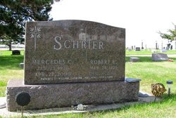
| Burial | : | Mabton Cemetery, Mabton, Yakima County, USA |
| Coordinate | : | 46.2285995, -119.9852982 |
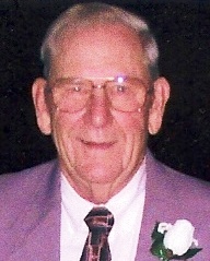
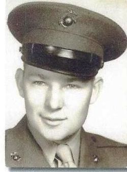
| Description | : | *** IN LOVING MEMORY OF *** Robert Eugene Schrier was born on Saturday; March 28, 1925 in Waterloo; Black Hawk County, Iowa at the Saint Francis Hospital. He was the son of: Joseph M. and Kathryn Griffin Schrier. Robert was raised on the family farm, northwest of Buckingham; Tama County, Iowa where he lived and worked. He graduated from Traer High School in Traer; Tama County, Iowa with the class of 1942. Bob joined the United States Marine Corps in 1943 and served as a tail gunner in a B-25 Mitchell bomber during World War II. He was honorably discharged... Read More |
frequently asked questions (FAQ):
-
Where is Robert Eugene Schrier's memorial?
Robert Eugene Schrier's memorial is located at: Mabton Cemetery, Mabton, Yakima County, USA.
-
When did Robert Eugene Schrier death?
Robert Eugene Schrier death on 31 Dec 2007 in Waterloo, Black Hawk County, Iowa, USA
-
Where are the coordinates of the Robert Eugene Schrier's memorial?
Latitude: 46.2285995
Longitude: -119.9852982
Family Members:
Parent
Spouse
Siblings
Flowers:
Nearby Cemetories:
1. Mabton Cemetery
Mabton, Yakima County, USA
Coordinate: 46.2285995, -119.9852982
2. Grandview Cemetery
Grandview, Yakima County, USA
Coordinate: 46.2658005, -119.8902969
3. Holy Trinity Episcopal Close
Sunnyside, Yakima County, USA
Coordinate: 46.3235000, -120.0158500
4. Outlook Cemetery
Yakima, Yakima County, USA
Coordinate: 46.3208008, -120.0811005
5. Lower Valley Memorial Gardens
Sunnyside, Yakima County, USA
Coordinate: 46.3450012, -120.0117035
6. Prosser Pioneer Cemetery
Prosser, Benton County, USA
Coordinate: 46.1947937, -119.8095245
7. Prosser Cemetery
Prosser, Benton County, USA
Coordinate: 46.2047539, -119.7541504
8. Glade Cemetery
Yakima County, USA
Coordinate: 46.0778008, -120.0914001
9. Smohalla Cemetery
Toppenish, Yakima County, USA
Coordinate: 46.3009660, -120.2186250
10. Beaver Cemetery
Yakima County, USA
Coordinate: 46.0993996, -120.2866974
11. McCoy Cemetery
Toppenish, Yakima County, USA
Coordinate: 46.3835983, -120.2755966
12. Zillah German Baptist Cemetery
Zillah, Yakima County, USA
Coordinate: 46.4128550, -120.2506400
13. Winnier Cemetery
Toppenish, Yakima County, USA
Coordinate: 46.3590060, -120.3192450
14. Zillah Cemetery
Zillah, Yakima County, USA
Coordinate: 46.4055202, -120.2726072
15. Elmwood Cemetery
Toppenish, Yakima County, USA
Coordinate: 46.3673830, -120.3334530
16. Black Rock Cemetery
Moxee City, Yakima County, USA
Coordinate: 46.5111084, -119.9985962
17. Methodist Cemetery
Bickleton, Klickitat County, USA
Coordinate: 46.0041161, -120.2838135
18. Smina Cemetery
Yakima County, USA
Coordinate: 46.2372017, -120.4269028
19. IOOF Cemetery
Bickleton, Klickitat County, USA
Coordinate: 46.0133018, -120.3035965
20. Onepennee Cemetery
Yakima County, USA
Coordinate: 46.0550003, -120.3871994
21. Meninick Cemetery
Yakima County, USA
Coordinate: 46.1981010, -120.4741974
22. Evergreen Cemetery
Benton City, Benton County, USA
Coordinate: 46.2867012, -119.4938965
23. Sixprong Cemetery
Sixprong, Klickitat County, USA
Coordinate: 45.8810997, -120.0224991
24. Horse Heaven Hills Cemetery
Benton County, USA
Coordinate: 46.1551018, -119.4826736

