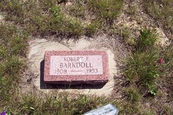
Robert Franklin Dial Barkdoll
| Birth | : | 17 Mar 1908 Missouri, USA |
| Death | : | 31 Oct 1953 Winnett, Petroleum County, Montana, USA |
| Burial | : | Winnett City Cemetery, Petroleum County, USA |
| Coordinate | : | 47.0181900, -108.3558400 |
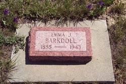
| Description | : | ***** Robert Franklin was born in Missouri to mother Emma Jane Dial, daughter of Rebecca Jane Hargar (1852 – 1942) and James D Dial (1837 – 1890). The 1910 Census record shows him living in the house of his Uncle Leon Dial, with his Mom and Grandmother Rebecca Dial. In 1911 In Missouri his Mom married Ruben Abner Barkdoll (1874 – 1929) after the death of his first wife Viola Gertrude Dial (1883 – 1910). Viola was his Mom's sister. Ruben's family included his 2 children; Floyde Barkdoll 1905 – 1958 Opal Barkdoll 1908 – 1914 Ruben and... Read More |
frequently asked questions (FAQ):
-
Where is Robert Franklin Dial Barkdoll's memorial?
Robert Franklin Dial Barkdoll's memorial is located at: Winnett City Cemetery, Petroleum County, USA.
-
When did Robert Franklin Dial Barkdoll death?
Robert Franklin Dial Barkdoll death on 31 Oct 1953 in Winnett, Petroleum County, Montana, USA
-
Where are the coordinates of the Robert Franklin Dial Barkdoll's memorial?
Latitude: 47.0181900
Longitude: -108.3558400
Family Members:
Parent
Spouse
Siblings
Flowers:
Nearby Cemetories:
1. Winnett City Cemetery
Petroleum County, USA
Coordinate: 47.0181900, -108.3558400
2. Cat Creek Cemetery
Winnett, Petroleum County, USA
Coordinate: 47.0816394, -108.1663116
3. Ashley Cemetery
Winnett, Petroleum County, USA
Coordinate: 47.1666775, -108.2810059
4. Flatwillow Cemetery
Flatwillow, Petroleum County, USA
Coordinate: 46.8288640, -108.4004060
5. Wallview Cemetery
Flatwillow, Petroleum County, USA
Coordinate: 46.7644970, -108.4732787
6. Flat Willow Hutterite Colony Cemetery
Flatwillow Colony, Musselshell County, USA
Coordinate: 46.7236654, -108.4919070
7. Grass Range Cemetery
Grass Range, Fergus County, USA
Coordinate: 47.0229190, -108.8119200
8. Gilfeather Cemetery
Benzien, Garfield County, USA
Coordinate: 47.2348310, -107.9476920
9. Ford's Creek Colony
Grass Range, Fergus County, USA
Coordinate: 47.1306882, -108.9208610
10. Ayers Ranch Hutterite Cemetery
Grass Range, Fergus County, USA
Coordinate: 47.0507550, -108.9514013
11. Ayers Ranch Colony Cemetery
Ayers Ranch Colony, Fergus County, USA
Coordinate: 47.0508000, -108.9514000
12. Coon Cemetery
Garfield County, USA
Coordinate: 47.3263790, -107.9323320
13. Forest Grove Cemetery
Fergus County, USA
Coordinate: 46.9909000, -109.0752000
14. Roy Cemetery
Roy, Fergus County, USA
Coordinate: 47.3404680, -108.9571450
15. Minerva Creek Cemetery
Roundup, Musselshell County, USA
Coordinate: 46.7216370, -108.9834300
16. Wolf Cemetery
Garfield County, USA
Coordinate: 47.1528015, -107.5924988
17. Melstone Cemetery
Melstone, Musselshell County, USA
Coordinate: 46.6068993, -107.8507996
18. Kilby Butte Hutterite Cemetery
Musselshell County, USA
Coordinate: 46.4746694, -108.3626017
19. Musselshell Cemetery
Musselshell County, USA
Coordinate: 46.4989014, -108.0888977
20. Fort Maginnis Cemetery
Giltedge, Fergus County, USA
Coordinate: 47.1869011, -109.1461029
21. Roundup Cemetery
Roundup, Musselshell County, USA
Coordinate: 46.4558560, -108.5060570
22. Great Divide Cemetery
Piper, Fergus County, USA
Coordinate: 46.9978000, -109.2046000
23. Giltedge Cemetery
Giltedge, Fergus County, USA
Coordinate: 47.1323800, -109.2033700
24. Miracle Lodge Number 84 Cemetery
Klein, Musselshell County, USA
Coordinate: 46.4185220, -108.5611120


