
| Birth | : | 20 Dec 1914 De Leon, Comanche County, Texas, USA |
| Death | : | 17 Apr 1993 Deming, Luna County, New Mexico, USA |
| Burial | : | Oroville Riverview Cemetery, Oroville, Okanogan County, USA |
| Coordinate | : | 48.9202700, -119.4458500 |
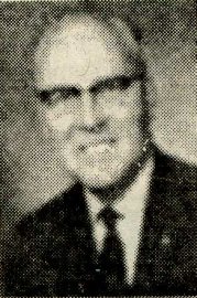
| Description | : | Robert Lee Wisdom, 78, Truth or Consequences, New Mexico, a former resident of Oroville, died Saturday, April 17, 1993, in the New Mexico Veterans Center. He was born December 20, 1914, in Comanche County, Texas, to Joseph and Leller Wisdom. He moved to Oroville at a young age. He served all during World War II with the US Army 3rd Infantry Division in Africa and Europe. He married Amie Marguerite Stephen in 1945. Mrs. Wisdom managed the state liquor store in Oroville and then owned and operated a Texaco station. He moved to Deming, New Mexico, in... Read More |
frequently asked questions (FAQ):
-
Where is Robert Lee Wisdom's memorial?
Robert Lee Wisdom's memorial is located at: Oroville Riverview Cemetery, Oroville, Okanogan County, USA.
-
When did Robert Lee Wisdom death?
Robert Lee Wisdom death on 17 Apr 1993 in Deming, Luna County, New Mexico, USA
-
Where are the coordinates of the Robert Lee Wisdom's memorial?
Latitude: 48.9202700
Longitude: -119.4458500
Family Members:
Parent

Spouse
Siblings
Flowers:


Nearby Cemetories:
1. Oroville Riverview Cemetery
Oroville, Okanogan County, USA
Coordinate: 48.9202700, -119.4458500
2. Old Riverview Cemetery
Oroville, Okanogan County, USA
Coordinate: 48.9177800, -119.4466700
3. Old Oroville Cemetery
Okanogan County, USA
Coordinate: 48.8913360, -119.4456230
4. Golden Cemetery
Okanogan County, USA
Coordinate: 48.9014015, -119.5203018
5. Mountain View Memorial Cemetery
Ellisforde, Okanogan County, USA
Coordinate: 48.8328300, -119.4011300
6. Ellisforde Mission Cemetery
Ellisforde, Okanogan County, USA
Coordinate: 48.7908300, -119.3972300
7. Mountain View Cemetery
Loomis, Okanogan County, USA
Coordinate: 48.8152700, -119.6100100
8. Osoyoos Lakeview Cemetery
Osoyoos, Okanagan-Similkameen Regional District, Canada
Coordinate: 49.0638600, -119.5185500
9. Little Chopaka Cemetery
Okanogan County, USA
Coordinate: 48.8272200, -119.6430600
10. Molson Cemetery
Molson, Okanogan County, USA
Coordinate: 48.9657000, -119.2105000
11. Sidley-Lawless Cemetery
Sidley, Kootenay Boundary Regional District, Canada
Coordinate: 49.0153330, -119.2234330
12. Immanuel Lutheran Cemetery
Havillah, Okanogan County, USA
Coordinate: 48.8305500, -119.2033500
13. Kipling Cemetery
Okanogan County, USA
Coordinate: 48.9080500, -119.1652900
14. Tonasket Cemetery
Tonasket, Okanogan County, USA
Coordinate: 48.7284400, -119.4328200
15. Valley Congregational Church Memorial Rose Garden
Oliver, Okanagan-Similkameen Regional District, Canada
Coordinate: 49.1169070, -119.5575920
16. Bridesville Cemetery
Bridesville, Kootenay Boundary Regional District, Canada
Coordinate: 49.0370800, -119.1372300
17. Chesaw Cemetery
Okanogan County, USA
Coordinate: 48.9299900, -119.0541800
18. Oliver Cemetery
Oliver, Okanagan-Similkameen Regional District, Canada
Coordinate: 49.1767600, -119.5697000
19. Fairview Cemetery
Fairview, Okanagan-Similkameen Regional District, Canada
Coordinate: 49.1742600, -119.5998800
20. Thorp Cemetery
Chesaw, Okanogan County, USA
Coordinate: 48.9549900, -119.0316700
21. Anglin Cemetery
Okanogan County, USA
Coordinate: 48.6627700, -119.2783400
22. Phillip Raux Gravesite
Riverside, Okanogan County, USA
Coordinate: 48.6271800, -119.3308500
23. Wauconda Cemetery
Wauconda, Okanogan County, USA
Coordinate: 48.7408300, -119.0597300
24. Pine Creek Cemetery
Tonasket, Okanogan County, USA
Coordinate: 48.6330560, -119.6502780