
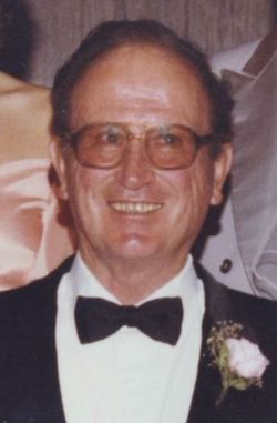
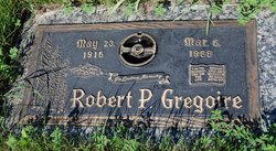
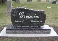
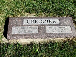
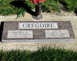
Robert Phillip “Bob” Gregoire
| Birth | : | 23 May 1916 Merrifield, Grand Forks County, North Dakota, USA |
| Death | : | 6 Mar 1988 Grand Forks, Grand Forks County, North Dakota, USA |
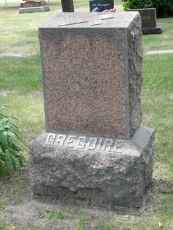
| Burial | : | Forest Lawn Cemetery, Thessalon, Algoma District, Canada |
| Coordinate | : | 46.2966640, -83.5545540 |
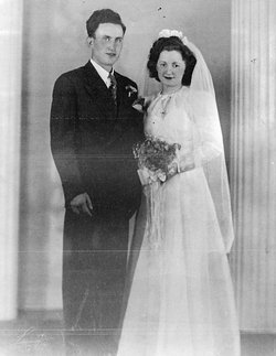
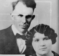
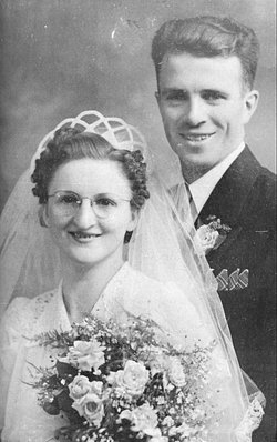
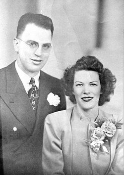
| Description | : | Robert P. Gregoire, 71, 2501 26th Avenue S., died Sunday, March 6, 1988 in The United Hospital in Grand Forks, ND. Services will be at 10:30 a.m., Wednesday, March 9, in Sacred Heart Catholic Church, East Grand Forks, MN. Visitation will be from 5 to 8 p.m. Tuesday, with an 8 p.m. prayer service, in Amundson Funeral Home, Grand Forks. Robert Phillip "Bob" Gregoire was born May 23, 1916, in Merrifield, ND, the son of Tancrede Louis and Olive (Fortier) Gregoire. On June 30, 1941, he married Veronica Brohman of Grand Forks. They farmed near Thompson, Buxton, Caledonia, and... Read More |
frequently asked questions (FAQ):
-
Where is Robert Phillip “Bob” Gregoire's memorial?
Robert Phillip “Bob” Gregoire's memorial is located at: Forest Lawn Cemetery, Thessalon, Algoma District, Canada.
-
When did Robert Phillip “Bob” Gregoire death?
Robert Phillip “Bob” Gregoire death on 6 Mar 1988 in Grand Forks, Grand Forks County, North Dakota, USA
-
Where are the coordinates of the Robert Phillip “Bob” Gregoire's memorial?
Latitude: 46.2966640
Longitude: -83.5545540
Family Members:
Parent
Spouse
Siblings
Children
Flowers:


Nearby Cemetories:
1. Forest Lawn Cemetery
Thessalon, Algoma District, Canada
Coordinate: 46.2966640, -83.5545540
2. Little Rapids Cemetery
Little Rapids, Algoma District, Canada
Coordinate: 46.2971500, -83.5546100
3. Pine Grove Cemetery
Thessalon, Algoma District, Canada
Coordinate: 46.3111420, -83.5409620
4. Maple Ridge Cemetery
Thessalon, Algoma District, Canada
Coordinate: 46.2787630, -83.4324530
5. Cloudslee Cemetery
Cloudslee, Algoma District, Canada
Coordinate: 46.3229580, -83.7078990
6. Trunk Road Cemetery
Bruce Mines, Algoma District, Canada
Coordinate: 46.3079480, -83.7614200
7. Humphrey Maple Grove Cemetery
Rydal Bank, Algoma District, Canada
Coordinate: 46.3818890, -83.7276440
8. Sands Cemetery
Plummer, Algoma District, Canada
Coordinate: 46.4222200, -83.7193410
9. Wharncliffe Cemetery
Wharncliffe, Algoma District, Canada
Coordinate: 46.4220820, -83.3754110
10. Dunn's Valley Cemetery
Dunns Valley, Algoma District, Canada
Coordinate: 46.4679832, -83.6253586
11. Plummer Cemetery
Plummer, Algoma District, Canada
Coordinate: 46.4030510, -83.7705810
12. Rock Lake Cemetery
Rock Lake, Algoma District, Canada
Coordinate: 46.4361992, -83.7270660
13. Bruce Mines Cemetery
Bruce Mines, Algoma District, Canada
Coordinate: 46.4167600, -83.7832200
14. Bellingham United Church Cemetery
Bellingham, Algoma District, Canada
Coordinate: 46.3960860, -83.2854860
15. Spruce Grove Cemetery
Iron Bridge, Algoma District, Canada
Coordinate: 46.2783570, -83.2384830
16. Arnill United Cemetery
Iron Bridge, Algoma District, Canada
Coordinate: 46.2780320, -83.2281310
17. Saint Boniface Catholic Cemetery
Hilton Beach, Algoma District, Canada
Coordinate: 46.2518340, -83.8799940
18. Carlyle Cemetery
Algoma District, Canada
Coordinate: 46.2637700, -83.2177140
19. Saint John's Anglican Cemetery
Hilton Beach, Algoma District, Canada
Coordinate: 46.2537500, -83.8982600
20. Mount Pleasant Cemetery
Gordon Lake, Algoma District, Canada
Coordinate: 46.4087150, -83.8672590
21. Grace United Cemetery
Hilton Beach, Algoma District, Canada
Coordinate: 46.2524630, -83.9040880
22. Poplar Dale Cemetery
Poplar Dale, Algoma District, Canada
Coordinate: 46.5209300, -83.7317400
23. Sunset Cemetery
Iron Bridge, Algoma District, Canada
Coordinate: 46.2549870, -83.1864410
24. Desbarats Cemetery
Desbarats, Algoma District, Canada
Coordinate: 46.3540760, -83.9434960