
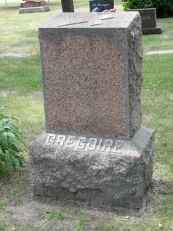
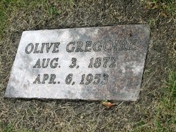

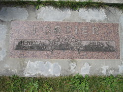
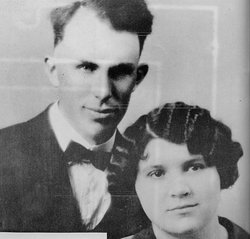
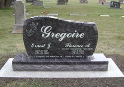
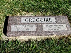
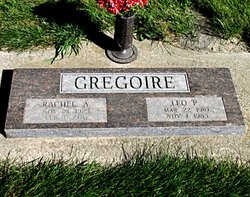
Amalie Olivia “Olive” Fortier Gregoire
| Birth | : | 3 Aug 1872 Saint Peter, Nicollet County, Minnesota, USA |
| Death | : | 6 Apr 1953 Grand Forks, Grand Forks County, North Dakota, USA |
| Burial | : | St Mary's and All Saints Churchyard, Little Melton, South Norfolk District, England |
| Coordinate | : | 52.6173083, 1.1798046 |
| Description | : | Mrs. Tancrede L. Gregoire "Olive", 80, a long-time resident of Thompson, ND, died Monday, April 6, 1953, at the St. Anne's Guest Home here where she had been residing for five months. Services will be held at 9:30 a.m., Thursday, at St. Michael's Catholic Church where Msgr. William McNamee will celebrate the solemn high mass. Burial will take place at Calvary Cemetery in Grand Forks. The body will lie in state this afternoon and evening at the Norman Funeral Home here where the rosary will be recited at 8 p.m. Olive was the former Amalie Olivia "Olive" Fortier and was... Read More |
frequently asked questions (FAQ):
-
Where is Amalie Olivia “Olive” Fortier Gregoire's memorial?
Amalie Olivia “Olive” Fortier Gregoire's memorial is located at: St Mary's and All Saints Churchyard, Little Melton, South Norfolk District, England.
-
When did Amalie Olivia “Olive” Fortier Gregoire death?
Amalie Olivia “Olive” Fortier Gregoire death on 6 Apr 1953 in Grand Forks, Grand Forks County, North Dakota, USA
-
Where are the coordinates of the Amalie Olivia “Olive” Fortier Gregoire's memorial?
Latitude: 52.6173083
Longitude: 1.1798046
Family Members:
Parent
Spouse
Siblings
Children

Flowers:


Nearby Cemetories:
1. St Mary's and All Saints Churchyard
Little Melton, South Norfolk District, England
Coordinate: 52.6173083, 1.1798046
2. All Saints & St Mary Churchyard
Great Melton, South Norfolk District, England
Coordinate: 52.6108700, 1.1602200
3. Colney Woodland Burial Park
Colney, South Norfolk District, England
Coordinate: 52.6254580, 1.1991560
4. St. Mary and St. Walstan Churchyard
Bawburgh, South Norfolk District, England
Coordinate: 52.6327480, 1.1796530
5. Saint Remigius Churchyard
Hethersett, South Norfolk District, England
Coordinate: 52.5992830, 1.1889340
6. St. Andrew Churchyard
Colney, South Norfolk District, England
Coordinate: 52.6253800, 1.2206100
7. St. Mary's Churchyard
Marlingford, South Norfolk District, England
Coordinate: 52.6310660, 1.1416800
8. St Michael's Church
Bowthorpe, City of Norwich, England
Coordinate: 52.6359300, 1.2163600
9. St. Mary's Churchyard
Earlham, City of Norwich, England
Coordinate: 52.6280416, 1.2353034
10. Costessey Parish Cemetery
Costessey, South Norfolk District, England
Coordinate: 52.6495927, 1.2040157
11. St. Peter's Churchyard
Ketteringham, South Norfolk District, England
Coordinate: 52.5778000, 1.1921000
12. St. Peter's Churchyard
Cringleford, South Norfolk District, England
Coordinate: 52.6057990, 1.2453370
13. St. Peter's Churchyard
Easton, South Norfolk District, England
Coordinate: 52.6543660, 1.1478070
14. St Botolphs
Barford, South Norfolk District, England
Coordinate: 52.6287000, 1.1118000
15. St. Andrew's Old Churchyard
Eaton, City of Norwich, England
Coordinate: 52.6068200, 1.2514300
16. Our Lady & St. Walstan Churchyard
Costessey, South Norfolk District, England
Coordinate: 52.6583200, 1.2119300
17. All Saints Church, Intwood
Cringleford, South Norfolk District, England
Coordinate: 52.5910430, 1.2419930
18. Keswick Churchyard
Keswick, South Norfolk District, England
Coordinate: 52.5909460, 1.2419310
19. Costessey Baptist Churchyard
Costessey, South Norfolk District, England
Coordinate: 52.6600122, 1.2116993
20. Eaton Parish Burial Ground
Eaton, City of Norwich, England
Coordinate: 52.6053900, 1.2556800
21. St. Andrew's Churchyard
Colton, South Norfolk District, England
Coordinate: 52.6407700, 1.1089300
22. St Mary Churchyard
East Carleton, South Norfolk District, England
Coordinate: 52.5726700, 1.2153470
23. St Andrew's Churchyard
Honingham, Broadland District, England
Coordinate: 52.6573170, 1.1244600
24. St. Mary's Churchyard
Hellesdon, Broadland District, England
Coordinate: 52.6486720, 1.2515280