
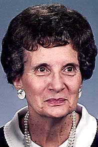

Roena K Blochberger Campbell
| Birth | : | 8 Jul 1922 Lohman, Cole County, Missouri, USA |
| Death | : | 16 Nov 2010 Russellville, Cole County, Missouri, USA |
| Burial | : | St Margaret Churchyard, Hales, South Norfolk District, England |
| Coordinate | : | 52.5109380, 1.5110840 |
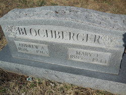
| Description | : | Roena K. Campbell, age 88, of Russellville, died Tuesday, November 16, 2010, at St. Josephís Home in Jefferson City. She was born July 8, 1922, in Lohman, a daughter of Andrew A. and Mary E. Berry Blochberger. On December 6, 1941, in Sedalia, Roena was united in marriage to Kenneth Campbell, who preceded her in death December 29, 1974. She was a graduate of Russellville High School. Roena was a homemaker for most of her life, staying busy raising her 11 children. For a few years she owned and operated Gloverís Tobacco Store in Russellville. She was a member of... Read More |
frequently asked questions (FAQ):
-
Where is Roena K Blochberger Campbell's memorial?
Roena K Blochberger Campbell's memorial is located at: St Margaret Churchyard, Hales, South Norfolk District, England.
-
When did Roena K Blochberger Campbell death?
Roena K Blochberger Campbell death on 16 Nov 2010 in Russellville, Cole County, Missouri, USA
-
Where are the coordinates of the Roena K Blochberger Campbell's memorial?
Latitude: 52.5109380
Longitude: 1.5110840
Family Members:
Parent

Spouse

Siblings
Children
Flowers:


Nearby Cemetories:
1. St Margaret Churchyard
Hales, South Norfolk District, England
Coordinate: 52.5109380, 1.5110840
2. St Andrews Churchyard
Raveningham, South Norfolk District, England
Coordinate: 52.5126430, 1.5323570
3. All Saints Churchyard
Kirby Cane, South Norfolk District, England
Coordinate: 52.4937500, 1.4952820
4. St Gregory Churchyard
Heckingham, South Norfolk District, England
Coordinate: 52.5350940, 1.5144710
5. Holy Trinity Churchyard
Loddon, South Norfolk District, England
Coordinate: 52.5350430, 1.4832560
6. Ss Mary and Margaret Churchyard
Norton Subcourse, North Norfolk District, England
Coordinate: 52.5324780, 1.5483860
7. Methodist Churchyard
Norton Subcourse, North Norfolk District, England
Coordinate: 52.5317630, 1.5557020
8. All Saints Churchyard
Chedgrave, South Norfolk District, England
Coordinate: 52.5409130, 1.4831200
9. St Michael Churchyard
Geldeston, South Norfolk District, England
Coordinate: 52.4759460, 1.5246070
10. St Mary's Churchyard
Ellingham, South Norfolk District, England
Coordinate: 52.4739393, 1.4827976
11. St Margaret's Churchyard
Hardley Street, South Norfolk District, England
Coordinate: 52.5522980, 1.5170630
12. All Saints Churchyard
Gillingham, South Norfolk District, England
Coordinate: 52.4753720, 1.5479546
13. St Michael's Churchyard
Broome, South Norfolk District, England
Coordinate: 52.4860360, 1.4547410
14. St Mary's Churchyard
Gillingham, South Norfolk District, England
Coordinate: 52.4750343, 1.5489500
15. Hardley Methodist Chapel
Langley with Hardley, South Norfolk District, England
Coordinate: 52.5577290, 1.4957960
16. St. Michaels's Church Cemetery
Langley with Hardley, South Norfolk District, England
Coordinate: 52.5552220, 1.4727530
17. Thorpe-next-Haddiscoe St Mathias Churchyard
Haddiscoe, South Norfolk District, England
Coordinate: 52.5261880, 1.5896380
18. St. Mary's Churchyard
Haddiscoe, South Norfolk District, England
Coordinate: 52.5153200, 1.5939300
19. St Peter's Churchyard
Mundham, South Norfolk District, England
Coordinate: 52.5303890, 1.4260120
20. St. Bartholomew's Churchyard
Shipmeadow, Waveney District, England
Coordinate: 52.4557540, 1.5046408
21. Wangford Union Workhouse Cemetery
Shipmeadow, Waveney District, England
Coordinate: 52.4540960, 1.4997050
22. All Saints Churchyard
Mettingham, Waveney District, England
Coordinate: 52.4566620, 1.4764720
23. Ditchingham Cemetery
Ditchingham, South Norfolk District, England
Coordinate: 52.4793614, 1.4307304
24. St Margaret and St Remigius Churchyard
Seething, South Norfolk District, England
Coordinate: 52.5303390, 1.4185000