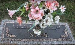
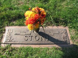
Roger Lee Stone
| Birth | : | 29 Dec 1941 |
| Death | : | 25 May 2009 |
| Burial | : | Grimesthorpe Cemetery, Grimsthorpe, Manitoulin District, Canada |
| Coordinate | : | 45.7098120, -82.3246620 |
| Description | : | Roger Lee Stone, 67, of Uneeda died at home Monday, May 25, 2009 after an extended illness. Roger began his career with C & P Telephone, retiring from Verizon with 30 years of service. He was a member of the Uneeda Church of Christ, the Telephone Pioneers and the NRA. He was preceded in death by his parents, Virgil and Gay Stone. He is survived by his wife, Linda Charles Stone; his daughter, Sheila Bias and her husband Wendell of South Charleston; sisters, Janet Jones of Amissville, Va. and Carol Rollins of Leesburg, Fla.; one brother, Dean Stone of Amissville,... Read More |
frequently asked questions (FAQ):
-
Where is Roger Lee Stone's memorial?
Roger Lee Stone's memorial is located at: Grimesthorpe Cemetery, Grimsthorpe, Manitoulin District, Canada.
-
When did Roger Lee Stone death?
Roger Lee Stone death on 25 May 2009 in
-
Where are the coordinates of the Roger Lee Stone's memorial?
Latitude: 45.7098120
Longitude: -82.3246620
Family Members:
Parent
Flowers:
Nearby Cemetories:
1. Grimesthorpe Cemetery
Grimsthorpe, Manitoulin District, Canada
Coordinate: 45.7098120, -82.3246620
2. Providence Bay Cemetery
Providence Bay, Manitoulin District, Canada
Coordinate: 45.6728600, -82.2664600
3. Mindemoya Cemetery
Mindemoya, Manitoulin District, Canada
Coordinate: 45.7473100, -82.1928000
4. Long Bay Cemetery
Long Bay, Manitoulin District, Canada
Coordinate: 45.8056680, -82.3795380
5. M'Chigeeng Cemetery
West Bay, Manitoulin District, Canada
Coordinate: 45.8163400, -82.1601200
6. Burpee Mills Cemetery
Burpee and Mills, Manitoulin District, Canada
Coordinate: 45.7685100, -82.5328800
7. Big Lake Cemetery
Manitoulin, Manitoulin District, Canada
Coordinate: 45.7457500, -82.0575900
8. Gordon Cemetery
Gordon, Manitoulin District, Canada
Coordinate: 45.8757300, -82.4724300
9. Kagawong Cedars Cemetery
Kagawong, Manitoulin District, Canada
Coordinate: 45.9089600, -82.2568300
10. Cold Springs Cemetery
Cold Springs, Manitoulin District, Canada
Coordinate: 45.8595060, -82.1087820
11. Fairview Cemetery
Tehkummah, Manitoulin District, Canada
Coordinate: 45.6564280, -82.0034580
12. Green Bay United Church Cemetery
Manitoulin, Manitoulin District, Canada
Coordinate: 45.8603520, -82.0223110
13. Hilly Grove Cemetery
Hilly Grove, Manitoulin District, Canada
Coordinate: 45.6789600, -81.8764700
14. Sheguiandah Reserve Cemetery
Sheguiandah, Manitoulin District, Canada
Coordinate: 45.8809640, -81.9049780
15. Elm View Cemetery
Howland, Manitoulin District, Canada
Coordinate: 45.9045270, -81.9204550
16. Sucker Creek Cemetery
Sucker Creek, Manitoulin District, Canada
Coordinate: 45.9604060, -81.9764140
17. Mountain View Cemetery
Little Current, Manitoulin District, Canada
Coordinate: 45.9604400, -81.9523100
18. St. Paul's Anglican Cemetery
Manitowaning, Manitoulin District, Canada
Coordinate: 45.7447912, -81.8061589
19. Holy Trinity Anglican Cemetery
Little Current, Manitoulin District, Canada
Coordinate: 45.9677590, -81.9439240
20. St. Bernard's Catholic Cemetery
Little Current, Manitoulin District, Canada
Coordinate: 45.9789170, -81.9596700
21. Buzwah Cemetery
Buzwah, Manitoulin District, Canada
Coordinate: 45.7660100, -81.7644500
22. Silver Lake Cemetery
Silver Water, Manitoulin District, Canada
Coordinate: 45.8578000, -82.8552000
23. Sheshegwaning Catholic Cemetery
Sheshegwaning, Manitoulin District, Canada
Coordinate: 45.9369839, -82.8383913
24. Sheshegwaning Anglican Cemetery
Sheshegwaning, Manitoulin District, Canada
Coordinate: 45.9368920, -82.8522804


