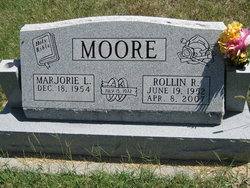
Rollin R. Moore
| Birth | : | 19 Jun 1952 Moran, Allen County, Kansas, USA |
| Death | : | 8 Apr 2007 Kincaid, Anderson County, Kansas, USA |
| Burial | : | Mount Olivet Cemetery, Watertown, Litchfield County, USA |
| Coordinate | : | 41.6185989, -73.1492004 |
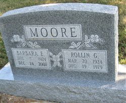
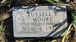
| Description | : | ************************* Obituary ~ Iola Register ~ Iola, KS ~ April 10, 2007 Rollin R. Moore of Kincaid, Kansas, died Sunday, April 8, 2007, at his home. He was born June 19, 1952, in Moran, Kansas, to Rollin G. and Barbara Gillaspie-Moore. He was graduated from Crest High school in 1971. He was a member of Covenant of Faith Christian Center in Iola, KS. On July 15, 1972, he was married to Marjorie Sluder in Blue Mound, Kansas. He is survived by his wife; a son, Steven and wife, Trisha, Silver Spring, MD; a brother, Rick and wife, Cheryl, Kincaid, KS; two sisters, Marjorie... Read More |
frequently asked questions (FAQ):
-
Where is Rollin R. Moore's memorial?
Rollin R. Moore's memorial is located at: Mount Olivet Cemetery, Watertown, Litchfield County, USA.
-
When did Rollin R. Moore death?
Rollin R. Moore death on 8 Apr 2007 in Kincaid, Anderson County, Kansas, USA
-
Where are the coordinates of the Rollin R. Moore's memorial?
Latitude: 41.6185989
Longitude: -73.1492004
Family Members:
Parent
Siblings
Children
Flowers:
Nearby Cemetories:
1. Mount Olivet Cemetery
Watertown, Litchfield County, USA
Coordinate: 41.6185989, -73.1492004
2. Evergreen Cemetery
Watertown, Litchfield County, USA
Coordinate: 41.6082993, -73.1235962
3. Mount Saint James Cemetery
Watertown, Litchfield County, USA
Coordinate: 41.6100006, -73.1093979
4. Old Watertown Cemetery
Watertown, Litchfield County, USA
Coordinate: 41.5993996, -73.1138992
5. Abbey of Regina Laudis Cemetery
Bethlehem, Litchfield County, USA
Coordinate: 41.6116400, -73.2100800
6. Evergreen Cemetery
Bethlehem, Litchfield County, USA
Coordinate: 41.6306000, -73.2099991
7. Old Bethlehem Cemetery
Bethlehem, Litchfield County, USA
Coordinate: 41.6486015, -73.2089005
8. All Saints Episcopal Church Memorial Garden
Oakville, Litchfield County, USA
Coordinate: 41.5885620, -73.0856160
9. Hillside Cemetery
Thomaston, Litchfield County, USA
Coordinate: 41.6685982, -73.0819016
10. Fort Hill Cemetery
Waterbury, New Haven County, USA
Coordinate: 41.5943413, -73.0548553
11. Farband Cemetery
Morris, Litchfield County, USA
Coordinate: 41.6890182, -73.1839447
12. Morris Burying Ground
Morris, Litchfield County, USA
Coordinate: 41.6883300, -73.1865400
13. Carmel Hill Cemetery
Bethlehem, Litchfield County, USA
Coordinate: 41.6385994, -73.2481003
14. Thomaston Veterans Monument
Thomaston, Litchfield County, USA
Coordinate: 41.6739640, -73.0727780
15. New North Cemetery
Woodbury, Litchfield County, USA
Coordinate: 41.5519280, -73.2106860
16. Old North Cemetery
Woodbury, Litchfield County, USA
Coordinate: 41.5506070, -73.2096290
17. Orton Family Plot
Woodbury, Litchfield County, USA
Coordinate: 41.5488777, -73.2097855
18. West Side Cemetery
Goshen, Litchfield County, USA
Coordinate: 41.6707993, -73.0603027
19. West Cemetery
Plymouth, Litchfield County, USA
Coordinate: 41.6709595, -73.0592499
20. Northfield Cemetery
Northfield, Litchfield County, USA
Coordinate: 41.6972008, -73.1031036
21. Middlebury Cemetery
Middlebury, New Haven County, USA
Coordinate: 41.5341988, -73.1264038
22. Plymouth Burying Ground
Plymouth, Litchfield County, USA
Coordinate: 41.6726913, -73.0542374
23. Beth El Cemetery
Waterbury, New Haven County, USA
Coordinate: 41.5951385, -73.0333328
24. South Cemetery
Woodbury, Litchfield County, USA
Coordinate: 41.5407982, -73.2091980


