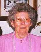
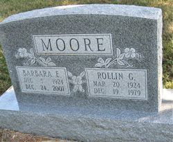
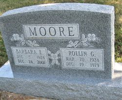
Barbara Eulits Gillaspie Moore
| Birth | : | 3 Dec 1924 Bronson, Bourbon County, Kansas, USA |
| Death | : | 24 Dec 2007 Kincaid, Anderson County, Kansas, USA |
| Burial | : | North East United Methodist Cemetery, North East, Cecil County, USA |
| Coordinate | : | 39.5971985, -75.9356003 |
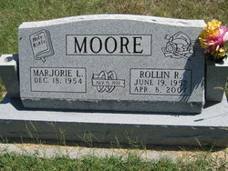
| Description | : | ********************** Barbara F. Moore, 83, Kincaid, Kansas, died Monday, Dec. 24, 2007, at her home. She was born December 3, 1924, in rural Bronson, Kansas, the daughter of George and Nancy Mae (Colgin) Gillaspie. She grew up southeast of Bayard, Kansas. Barbara graduated from Mildred High School in 1942. Barbara married Rollin G. Moore on May 9, 1942, in Nevada, Missouri. The couple moved to California in 1943, returning in 1946 to the Moore family farm, southwest of Kincaid, where Barbara resided until her death. She enjoyed reading and cooking Sunday family dinners. Her grandchildren were a great source of joy. She was... Read More |
frequently asked questions (FAQ):
-
Where is Barbara Eulits Gillaspie Moore's memorial?
Barbara Eulits Gillaspie Moore's memorial is located at: North East United Methodist Cemetery, North East, Cecil County, USA.
-
When did Barbara Eulits Gillaspie Moore death?
Barbara Eulits Gillaspie Moore death on 24 Dec 2007 in Kincaid, Anderson County, Kansas, USA
-
Where are the coordinates of the Barbara Eulits Gillaspie Moore's memorial?
Latitude: 39.5971985
Longitude: -75.9356003
Family Members:
Parent
Spouse
Siblings
Children
Flowers:
Nearby Cemetories:
1. Saint Mary Annes Episcopal Church Cemetery
North East, Cecil County, USA
Coordinate: 39.5966454, -75.9419403
2. Mount Carmel Baptist Cemetery
Cecil County, USA
Coordinate: 39.6048500, -75.9403500
3. Logan Family Cemetery
Bay View, Cecil County, USA
Coordinate: 39.6301200, -75.9619200
4. Boulden Chapel Cemetery
Cecil County, USA
Coordinate: 39.6258011, -75.9011002
5. Charlestown Cemetery
Charlestown, Cecil County, USA
Coordinate: 39.5735920, -75.9760590
6. Bethel United Methodist Church Cemetery
Bay View, Cecil County, USA
Coordinate: 39.6156400, -75.9852000
7. Wesley Chapel of Elk Neck Cemetery
Elk Neck, Cecil County, USA
Coordinate: 39.5616989, -75.8917007
8. Bay View Cemetery
Bay View, Cecil County, USA
Coordinate: 39.6449700, -75.9617500
9. Union Cemetery
Elkton, Cecil County, USA
Coordinate: 39.6472015, -75.9105988
10. Church of Christ Cemetery
Cecil County, USA
Coordinate: 39.6297964, -75.8574304
11. Oblates of Saint Francis de Sales Cemetery
Childs, Cecil County, USA
Coordinate: 39.6401367, -75.8635483
12. Leeds Cemetery
Elkton, Cecil County, USA
Coordinate: 39.6549988, -75.8764038
13. Indian Burial Ground
Elkton, Cecil County, USA
Coordinate: 39.5979150, -75.8360460
14. Immaculate Conception Parish Cemetery
Elkton, Cecil County, USA
Coordinate: 39.6080500, -75.8338100
15. Alms House Potters Field
Cherry Hill, Cecil County, USA
Coordinate: 39.6526000, -75.8587500
16. Oblate Sisters of Saint Francis de Sales Cemetery
Childs, Cecil County, USA
Coordinate: 39.6525879, -75.8577881
17. Zion Methodist Cemetery
Zion, Cecil County, USA
Coordinate: 39.6761470, -75.9656630
18. Zion Presbyterian Cemetery
Zion, Cecil County, USA
Coordinate: 39.6767370, -75.9666900
19. Sewell Family Vault
Elkton, Cecil County, USA
Coordinate: 39.6022700, -75.8278190
20. Ebenezer Cemetery
Rising Sun, Cecil County, USA
Coordinate: 39.6585600, -76.0102800
21. Gilpin Cemetery
Cecil County, USA
Coordinate: 39.6231003, -75.8302994
22. Principio United Methodist Church Cemetery
Principio Furnace, Cecil County, USA
Coordinate: 39.5741100, -76.0425400
23. Elkton Cemetery
Elkton, Cecil County, USA
Coordinate: 39.6074982, -75.8253021
24. Elkton Presbyterian Cemetery
Elkton, Cecil County, USA
Coordinate: 39.6100800, -75.8254600

