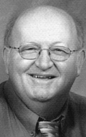
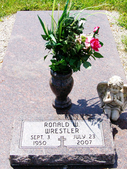
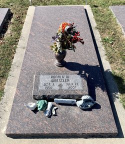
Ronald Wayne Wrestler
| Birth | : | 3 Sep 1950 Chanute, Neosho County, Kansas, USA |
| Death | : | 23 Jul 2007 Barton County, Kansas, USA |
| Burial | : | Saint John the Baptist Orthodox Cemetery, Stratford, Fairfield County, USA |
| Coordinate | : | 41.2285995, -73.1513977 |
| Plot | : | Sec 200 Blk 5 Lot 76 Sp 6 |
| Description | : | ***************** Chanute Tribune ~ Chanute, KS ~ July 27, 2007 Ronald Wayne Wrestler, 56, Lamar, Missouri, died at 12:18 a.m. Monday, July 23, 2007, at Barton County Memorial Hospital in Lamar, Missouri. He was born Sept. 3, 1950, in Chanute, Kansas, to Bob and Bonnie (Harvey) Wrestler. He graduated from Owasso (OK) High School in 1968. He was a member of the Jaycees, the Lion's Club, and the Oakton United Methodist Church. On July 23, 1994, at Independence, Missouri, he married Pamela J. Richey. She survives. Other survivors include a son and daughter-in-law, Roger and Amy Wrestler, Webb City, MO; three daughters and a son-in-law, Tracy... Read More |
frequently asked questions (FAQ):
-
Where is Ronald Wayne Wrestler's memorial?
Ronald Wayne Wrestler's memorial is located at: Saint John the Baptist Orthodox Cemetery, Stratford, Fairfield County, USA.
-
When did Ronald Wayne Wrestler death?
Ronald Wayne Wrestler death on 23 Jul 2007 in Barton County, Kansas, USA
-
Where are the coordinates of the Ronald Wayne Wrestler's memorial?
Latitude: 41.2285995
Longitude: -73.1513977
Family Members:
Parent
Flowers:
Nearby Cemetories:
1. Saint John the Baptist Orthodox Cemetery
Stratford, Fairfield County, USA
Coordinate: 41.2285995, -73.1513977
2. Trinity Episcopal Church Memorial Gardens
Trumbull, Fairfield County, USA
Coordinate: 41.2407870, -73.1616710
3. Nichols Farm Burial Ground
Trumbull, Fairfield County, USA
Coordinate: 41.2430992, -73.1578903
4. Nichols United Methodist Church Memorial Garden
Trumbull, Fairfield County, USA
Coordinate: 41.2424970, -73.1605450
5. Nichols Farm Burial Ground West Yard
Trumbull, Fairfield County, USA
Coordinate: 41.2410500, -73.1648000
6. Unity Burial Ground
Trumbull, Fairfield County, USA
Coordinate: 41.2364006, -73.1753006
7. Putney - Oronoque Cemetery
Stratford, Fairfield County, USA
Coordinate: 41.2336693, -73.1125793
8. Union Cemetery
Stratford, Fairfield County, USA
Coordinate: 41.1973000, -73.1295000
9. Trumbull Center Cemetery
Trumbull, Fairfield County, USA
Coordinate: 41.2449989, -73.1947021
10. Lakeview Cemetery
Bridgeport, Fairfield County, USA
Coordinate: 41.1955986, -73.1735992
11. Old Congregational Burying Ground
Stratford, Fairfield County, USA
Coordinate: 41.1911812, -73.1319275
12. Riverside Cemetery
Trumbull, Fairfield County, USA
Coordinate: 41.2486000, -73.1986008
13. Park Cemetery
Bridgeport, Fairfield County, USA
Coordinate: 41.2024994, -73.1956024
14. Christ Episcopal Church Cemetery
Stratford, Fairfield County, USA
Coordinate: 41.1897202, -73.1286316
15. Saint Augustine Cemetery
Bridgeport, Fairfield County, USA
Coordinate: 41.1888880, -73.1734890
16. Saint Michael's Cemetery
Stratford, Fairfield County, USA
Coordinate: 41.1796989, -73.1517029
17. Long Hill Burial Ground
Trumbull, Fairfield County, USA
Coordinate: 41.2491989, -73.2182999
18. Huntington Lawn Cemetery South
Huntington, Fairfield County, USA
Coordinate: 41.2874210, -73.1388740
19. Gate of Heaven Cemetery
Trumbull, Fairfield County, USA
Coordinate: 41.2804604, -73.2017136
20. Huntington Lawn Cemetery East
Huntington, Fairfield County, USA
Coordinate: 41.2933050, -73.1409250
21. Tower Crypt United Congregational Church Cemetery
Bridgeport, Fairfield County, USA
Coordinate: 41.1734370, -73.1977420
22. Old Cemetery of Huntington
Huntington, Fairfield County, USA
Coordinate: 41.2941017, -73.1458511
23. Huntington Lawn Cemetery West
Huntington, Fairfield County, USA
Coordinate: 41.2942009, -73.1436005
24. Saint Paul Cemetery
Shelton, Fairfield County, USA
Coordinate: 41.2947190, -73.1463800


