


Rosanna T “Rosie” Stolmeier Schinstock
| Birth | : | 14 Oct 1930 Fort Madison, Lee County, Iowa, USA |
| Death | : | 17 Nov 2015 Lee County, Iowa, USA |
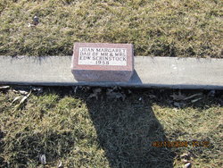
| Burial | : | Saint Johns Cemetery, Houghton, Lee County, USA |
| Coordinate | : | 40.7855000, -91.6010000 |
| Description | : | Rosanna T. “Rosie” Schinstock, 85, of Houghton passed away at 11:20 A.M. Tuesday November 17, 2015 at the West Point Care Center. Born October 14, 1930 at Fort Madison, Iowa the daughter of Albert and Anna Sallen Stohlmeier. On November 27, 1954 at Sacred Heart Catholic Church in Fort Madison, Iowa she married Edward Francis Schinstock. He preceded her in death on April 13, 2014. Survivors include four sons, Larry (Sue) Schinstock of Salem, Iowa, Dale (Terri) Schinstock of Urbandale, Iowa, Ken Schinstock of Salem, Iowa and Randy (Sharon) Schinstock of Mt. Pleasant, Iowa, one daughter Kathy (Wayne) Walljasper of St. Paul, Iowa,... Read More |
frequently asked questions (FAQ):
-
Where is Rosanna T “Rosie” Stolmeier Schinstock's memorial?
Rosanna T “Rosie” Stolmeier Schinstock's memorial is located at: Saint Johns Cemetery, Houghton, Lee County, USA.
-
When did Rosanna T “Rosie” Stolmeier Schinstock death?
Rosanna T “Rosie” Stolmeier Schinstock death on 17 Nov 2015 in Lee County, Iowa, USA
-
Where are the coordinates of the Rosanna T “Rosie” Stolmeier Schinstock's memorial?
Latitude: 40.7855000
Longitude: -91.6010000
Family Members:
Parent

Spouse

Children

Flowers:


Nearby Cemetories:
1. Saint Johns Cemetery
Houghton, Lee County, USA
Coordinate: 40.7855000, -91.6010000
2. Old Pilot Grove Cemetery
Pilot Grove, Lee County, USA
Coordinate: 40.7935670, -91.5382150
3. Clay Grove Cemetery
West Point, Lee County, USA
Coordinate: 40.7425900, -91.5642800
4. East Grove Cemetery
Salem, Henry County, USA
Coordinate: 40.8329050, -91.5468410
5. McCracken Cemetery
Lee County, USA
Coordinate: 40.7274200, -91.5695500
6. Salem South Cemetery
Salem, Henry County, USA
Coordinate: 40.8470001, -91.6210022
7. Saint James Cemetery
Saint Paul, Lee County, USA
Coordinate: 40.7696000, -91.5185900
8. Kennedy Farm Cemetery
Houghton, Lee County, USA
Coordinate: 40.7444070, -91.6670000
9. Salem East Cemetery
Salem, Henry County, USA
Coordinate: 40.8569000, -91.6120500
10. Sharon Cemetery
Mount Hamill, Lee County, USA
Coordinate: 40.7261940, -91.6605410
11. Bayles Cemetery
Lee County, USA
Coordinate: 40.7990600, -91.7025700
12. New Garden Quaker Cemetery
Lee County, USA
Coordinate: 40.7780900, -91.4964100
13. Hicks Cemetery
Lowell, Henry County, USA
Coordinate: 40.8210840, -91.5004920
14. Bonnell Cemetery
Franklin, Lee County, USA
Coordinate: 40.7057991, -91.5635986
15. Boyleston Cemetery
Lowell, Henry County, USA
Coordinate: 40.8390250, -91.5051910
16. Sax Family Cemetery
Primrose, Lee County, USA
Coordinate: 40.7027890, -91.6502551
17. Hunting Cemetery
Salem, Henry County, USA
Coordinate: 40.8632250, -91.5386870
18. Cook Cemetery
Primrose, Lee County, USA
Coordinate: 40.6974983, -91.6318970
19. Beeler Cemetery
Lee County, USA
Coordinate: 40.6918983, -91.6132965
20. J Goldsmiths Burying Ground
West Point, Lee County, USA
Coordinate: 40.7333730, -91.4973000
21. Wallingford Cemetery
Harrisburg, Van Buren County, USA
Coordinate: 40.7567700, -91.7230000
22. Hillsboro Cemetery
Hillsboro, Henry County, USA
Coordinate: 40.8310400, -91.7145000
23. Creel Farm Cemetery
West Point, Lee County, USA
Coordinate: 40.7472220, -91.4752780
24. Blacksmith Cemetery
Franklin, Lee County, USA
Coordinate: 40.7078018, -91.5096970