

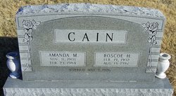
Roscoe Harold Cain
| Birth | : | 19 Feb 1902 Franklin County, Kansas, USA |
| Death | : | 13 Aug 1987 Ottawa, Franklin County, Kansas, USA |
| Burial | : | Mount Vernon Cemetery, Red Lick Township, Johnson County, USA |
| Coordinate | : | 35.5533400, -93.4238200 |
| Description | : | Ottawa Herald, Ottawa, KS (15 Aug 1987: 3) The funeral service for Mr. Roscoe Cain will be held from the Pomona United Methodist Church, Monday, August 17th at 2:00 p.m. Rev. Larry Smith officiating. Interment in Woodlawn Cemetery, Pomona. Mr. Cain will lie in state at the Dengel & Son Mortuary after 1:00 p.m., Saturday and Sunday, where the family will receive friends Sunday evening from 7 to 8. The family suggests memorials to the church. |
frequently asked questions (FAQ):
-
Where is Roscoe Harold Cain's memorial?
Roscoe Harold Cain's memorial is located at: Mount Vernon Cemetery, Red Lick Township, Johnson County, USA.
-
When did Roscoe Harold Cain death?
Roscoe Harold Cain death on 13 Aug 1987 in Ottawa, Franklin County, Kansas, USA
-
Where are the coordinates of the Roscoe Harold Cain's memorial?
Latitude: 35.5533400
Longitude: -93.4238200
Family Members:
Parent
Spouse
Siblings
Children
Flowers:


Nearby Cemetories:
1. Mount Vernon Cemetery
Red Lick Township, Johnson County, USA
Coordinate: 35.5533400, -93.4238200
2. Mount Airy Memorial Cemetery
Ludwig, Johnson County, USA
Coordinate: 35.5382996, -93.4282990
3. Johnson Family Cemetery
Johnson County, USA
Coordinate: 35.5583000, -93.4511032
4. East Mount Zion Cemetery
Johnson County, USA
Coordinate: 35.5606960, -93.4539160
5. King Cemetery
Ludwig, Johnson County, USA
Coordinate: 35.5377998, -93.4636002
6. Old King Cemetery
Johnson County, USA
Coordinate: 35.5303605, -93.4579615
7. Stillwell Cemetery
Clarksville, Johnson County, USA
Coordinate: 35.5191994, -93.4717026
8. Minnow Creek Cemetery
Hagarville, Johnson County, USA
Coordinate: 35.5111008, -93.3681030
9. Macedonia Cemetery
Lamar, Johnson County, USA
Coordinate: 35.4930992, -93.3799973
10. Lone Pine Cemetery
Clarksville, Johnson County, USA
Coordinate: 35.5546180, -93.5102610
11. Wood Cemetery
Johnson County, USA
Coordinate: 35.5317001, -93.5074997
12. Lee Cemetery
Clarksville, Johnson County, USA
Coordinate: 35.4844017, -93.4602966
13. Pryor Cemetery
Clarksville, Johnson County, USA
Coordinate: 35.4880981, -93.4803009
14. Hagarville Cemetery
Hagarville, Johnson County, USA
Coordinate: 35.5143776, -93.3373108
15. Holy Redeemer Cemetery
Clarksville, Johnson County, USA
Coordinate: 35.4728012, -93.4456024
16. Hagarville East Cemetery
Hagarville, Johnson County, USA
Coordinate: 35.5135994, -93.3341980
17. Greenbrier
Clarksville, Johnson County, USA
Coordinate: 35.4697450, -93.4169700
18. Woods Mountain Cemetery
Johnson County, USA
Coordinate: 35.5999985, -93.3313980
19. Woodland Memorial Cemetery
Clarksville, Johnson County, USA
Coordinate: 35.5177994, -93.5242004
20. Ozone Cemetery
Johnson County, USA
Coordinate: 35.6416850, -93.4442760
21. Walton Cemetery
Clarksville, Johnson County, USA
Coordinate: 35.4852982, -93.4982986
22. Adkins Cemetery
Johnson County, USA
Coordinate: 35.5233002, -93.3169022
23. Russell Cemetery
Ozone, Johnson County, USA
Coordinate: 35.6467018, -93.4199982
24. Pricetown Cemetery
Johnson County, USA
Coordinate: 35.4928017, -93.3330994