
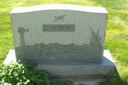
Rosemary DeSoto Guenzi
| Birth | : | 2 Mar 1923 Sterling, Logan County, Colorado, USA |
| Death | : | 20 Feb 1999 Sterling, Logan County, Colorado, USA |
| Burial | : | Broad Run Baptist Church Cemetery, Lightburn, Lewis County, USA |
| Coordinate | : | 39.1276190, -80.4395590 |
| Description | : | Rosemary Guenzi, 75, of Sterling, died Saturday, Feb. 20, 1999, in Sterling. Visitation and viewing will be at Chaney-Walters Funeral Home from 10 a.m. until 8 p.m., Tuesday, Feb. 23. A vigil service and rosary will be at 7 p.m., Tuesday, Feb. 23, at Chaney-Walters Funeral Home. A Mass of Christian Burial is set for 10 a.m., Wednesday, Feb. 24, at St. Anthony Catholic Church, with the Rev. Bob Whipkey officiating. Inurnment will be at Riverside Cemetery. Mrs. Guenzi was born on March 2, 1923 in Sterling to James and Pauline (Doglio) DeSoto. She was raised in Sterling where she attended Sanders... Read More |
frequently asked questions (FAQ):
-
Where is Rosemary DeSoto Guenzi's memorial?
Rosemary DeSoto Guenzi's memorial is located at: Broad Run Baptist Church Cemetery, Lightburn, Lewis County, USA.
-
When did Rosemary DeSoto Guenzi death?
Rosemary DeSoto Guenzi death on 20 Feb 1999 in Sterling, Logan County, Colorado, USA
-
Where are the coordinates of the Rosemary DeSoto Guenzi's memorial?
Latitude: 39.1276190
Longitude: -80.4395590
Family Members:
Parent

Spouse

Siblings

Flowers:


Nearby Cemetories:
1. Broad Run Baptist Church Cemetery
Lightburn, Lewis County, USA
Coordinate: 39.1276190, -80.4395590
2. McCan's Run United Methodist Church Cemetery
Weston, Lewis County, USA
Coordinate: 39.1163550, -80.4632670
3. Mount Hebron Cemetery
Jane Lew, Lewis County, USA
Coordinate: 39.1060982, -80.4255981
4. Bailey Cemetery
Westfield, Lewis County, USA
Coordinate: 39.1067470, -80.4560270
5. Pioneer Cemetery
Jane Lew, Lewis County, USA
Coordinate: 39.1071830, -80.4098780
6. Post Cemetery
Harrison County, USA
Coordinate: 39.1631012, -80.4413986
7. Jackson Cemetery
Jackson Mill, Lewis County, USA
Coordinate: 39.0974998, -80.4705963
8. Thomas Law Cemetery
Jane Lew, Lewis County, USA
Coordinate: 39.0893270, -80.4326240
9. McWhorter Church Cemetery
McWhorter, Harrison County, USA
Coordinate: 39.1281000, -80.3815670
10. Jesse Run Cemetery
Jane Lew, Lewis County, USA
Coordinate: 39.1038235, -80.3900664
11. Straley Cemetery
Jane Lew, Lewis County, USA
Coordinate: 39.0990820, -80.3941210
12. Pleasant Hill United Methodist Church Cemetery
Harrison County, USA
Coordinate: 39.1469990, -80.4944340
13. Duck Creek Cemetery
Lost Creek, Harrison County, USA
Coordinate: 39.1594009, -80.3949966
14. Harmony Cemetery
Jane Lew, Lewis County, USA
Coordinate: 39.0999985, -80.3899994
15. New Bethel Cemetery
Harrison County, USA
Coordinate: 39.1772003, -80.4392014
16. Good Hope Masonic Cemetery
Goodhope, Harrison County, USA
Coordinate: 39.1772300, -80.4393600
17. Hershey Cemetery
Lost Creek, Harrison County, USA
Coordinate: 39.1731500, -80.4091900
18. Gee Lick Cemetery
Weston, Lewis County, USA
Coordinate: 39.0787170, -80.4761610
19. Butcher Cemetery
Turnertown, Lewis County, USA
Coordinate: 39.0727997, -80.4614029
20. Mount Morris Cemetery
Freemansburg, Lewis County, USA
Coordinate: 39.1066510, -80.5128230
21. Hicks Cemetery
Lewis County, USA
Coordinate: 39.0717010, -80.4077988
22. Beech Grove Cemetery
Weston, Lewis County, USA
Coordinate: 39.1070170, -80.5141540
23. Forest Lawn Memorial Gardens
Jane Lew, Lewis County, USA
Coordinate: 39.0649986, -80.4328003
24. Bethel Cemetery
Goodhope, Harrison County, USA
Coordinate: 39.1903000, -80.4261017