| Birth | : | 1 Oct 1939 |
| Death | : | 2 Mar 2011 |
| Burial | : | Saints Peter and Paul Roman Catholic Cemetery, Lehighton, Carbon County, USA |
| Coordinate | : | 40.8401090, -75.7149770 |
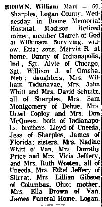
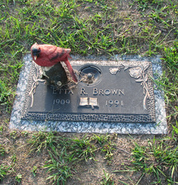
| Description | : | Rosetta was married to David Schultz. Rosetta was the daughter of Mart and Etta Brown. |
frequently asked questions (FAQ):
-
Where is Rosetta Brown Schultz's memorial?
Rosetta Brown Schultz's memorial is located at: Saints Peter and Paul Roman Catholic Cemetery, Lehighton, Carbon County, USA.
-
When did Rosetta Brown Schultz death?
Rosetta Brown Schultz death on 2 Mar 2011 in
-
Where are the coordinates of the Rosetta Brown Schultz's memorial?
Latitude: 40.8401090
Longitude: -75.7149770
Family Members:
Parent
Spouse
Siblings
Children
Flowers:
Nearby Cemetories:
1. Saints Peter and Paul Roman Catholic Cemetery
Lehighton, Carbon County, USA
Coordinate: 40.8401090, -75.7149770
2. All Saints Episcopal Church Cemetery
Lehighton, Carbon County, USA
Coordinate: 40.8371920, -75.7105930
3. Lehighton Cemetery
Lehighton, Carbon County, USA
Coordinate: 40.8297005, -75.7147980
4. Gnaden Huetten Cemetery
Lehighton, Carbon County, USA
Coordinate: 40.8272018, -75.7157974
5. Saint Matthew's Cemetery
Weissport, Carbon County, USA
Coordinate: 40.8415000, -75.6970000
6. Temple Israel Cemetery
Lehighton, Carbon County, USA
Coordinate: 40.8325000, -75.6988000
7. Packerton Cemetery
Packerton, Carbon County, USA
Coordinate: 40.8532982, -75.7232971
8. Franklin Heights Memorial Park
East Weissport, Carbon County, USA
Coordinate: 40.8338013, -75.6975021
9. Bunker Hill Cemetery
Weissport, Carbon County, USA
Coordinate: 40.8312000, -75.6981000
10. Union Hill Cemetery
Weissport, Carbon County, USA
Coordinate: 40.8285000, -75.6965000
11. Long Run Cemetery
Lehighton, Carbon County, USA
Coordinate: 40.8594010, -75.6948190
12. Mauch Chunk Cemetery
Jim Thorpe, Carbon County, USA
Coordinate: 40.8658000, -75.7404000
13. Saint John's Memorial Prayer Garden
Jim Thorpe, Carbon County, USA
Coordinate: 40.8661380, -75.7427770
14. Parryville Cemetery
Parryville, Carbon County, USA
Coordinate: 40.8227000, -75.6754000
15. Immaculate Conception Cemetery
Jim Thorpe, Carbon County, USA
Coordinate: 40.8767014, -75.7427979
16. Saint Joseph's Catholic Cemetery
Jim Thorpe, Carbon County, USA
Coordinate: 40.8797200, -75.7367860
17. Evergreen Cemetery
Jim Thorpe, Carbon County, USA
Coordinate: 40.8800011, -75.7391968
18. Jim Thorpe Memorial
Jim Thorpe, Carbon County, USA
Coordinate: 40.8846550, -75.7254870
19. Franklin Township Cemetery
Big Creek, Carbon County, USA
Coordinate: 40.8473660, -75.6518050
20. Saint Paulus Lutheran and Reformed Church Cemetery
Big Creek, Carbon County, USA
Coordinate: 40.8466500, -75.6514600
21. Trinity Lutheran Cemetery
Bowmanstown, Carbon County, USA
Coordinate: 40.8046989, -75.6652985
22. New Dinkey Memorial Cemetery
Ashfield, Carbon County, USA
Coordinate: 40.7878600, -75.7143400
23. Dinkey Memorial Cemetery
Lehighton, Carbon County, USA
Coordinate: 40.7872110, -75.7152820
24. Catholic Cemetery
Bowmanstown, Carbon County, USA
Coordinate: 40.8064850, -75.6605400


