
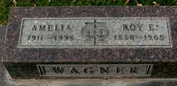
Roy Elmer Wagner
| Birth | : | 17 Mar 1896 Blairsburg, Hamilton County, Iowa, USA |
| Death | : | 10 Jan 1965 Forsyth, Rosebud County, Montana, USA |
| Burial | : | Forsyth Cemetery, Forsyth, Rosebud County, USA |
| Coordinate | : | 46.2689018, -106.6528015 |
| Plot | : | Booth Addition Section H Lot 4 Block 3 E1/2 |
| Description | : | SOURCE: Death Certificate: '''''''''''''''''''''''' The Billings Gazette, MT. 1/12/1965 Tuesday Page 16 Roy Wagner, 67, Forsyth Dies Forsyth, MT. ---- Roy Wagner, 67, Forsyth area rancher since 1935, died at his home suddenly on Sunday. He was born March 17, 1896, at Blairsburg, Iowa, the son of Samuel and Mary Wagner. The family moved to Washington and in 1909 to Hardin, MT. Mr. Wagner farmed near Myers, MT., until 1935, when he started ranching in the Hammond Bottom area near Forsyth. He married Amelia Mickell Sept. 26, 1938, in Miles City. Funeral services will... Read More |
frequently asked questions (FAQ):
-
Where is Roy Elmer Wagner's memorial?
Roy Elmer Wagner's memorial is located at: Forsyth Cemetery, Forsyth, Rosebud County, USA.
-
When did Roy Elmer Wagner death?
Roy Elmer Wagner death on 10 Jan 1965 in Forsyth, Rosebud County, Montana, USA
-
Where are the coordinates of the Roy Elmer Wagner's memorial?
Latitude: 46.2689018
Longitude: -106.6528015
Family Members:
Parent
Spouse

Siblings

Children
Flowers:


Nearby Cemetories:
1. Forsyth Cemetery
Forsyth, Rosebud County, USA
Coordinate: 46.2689018, -106.6528015
2. Rosebud Cemetery
Rosebud, Rosebud County, USA
Coordinate: 46.2689018, -106.4381027
3. Howard Cemetery
Rosebud County, USA
Coordinate: 46.2621994, -106.9222031
4. Hathaway Cemetery
Rosebud County, USA
Coordinate: 46.2616997, -106.2185974
5. Colstrip Cemetery
Colstrip, Rosebud County, USA
Coordinate: 45.9096985, -106.6194000
6. Memorial Vale Cemetery
Hysham, Treasure County, USA
Coordinate: 46.2552986, -107.2307968
7. Bean Cemetery
Rosebud County, USA
Coordinate: 45.8535995, -106.4011002
8. Brown Cemetery
Colstrip, Rosebud County, USA
Coordinate: 45.8321991, -106.4180984
9. Lee Cemetery
Rosebud County, USA
Coordinate: 45.7792015, -106.5413971
10. Rancher Cemetery
Myers, Treasure County, USA
Coordinate: 46.2580986, -107.4197006
11. Fort Keogh Cemetery
Custer County, USA
Coordinate: 46.3800011, -105.8874969
12. Vanstel Cemetery
Rosebud County, USA
Coordinate: 46.7872009, -106.8942032
13. Calvary Cemetery
Miles City, Custer County, USA
Coordinate: 46.3816986, -105.8249969
14. Eastern Montana State Veterans Cemetery
Miles City, Custer County, USA
Coordinate: 46.3807564, -105.8246536
15. Old Calvary Cemetery
Miles City, Custer County, USA
Coordinate: 46.3807600, -105.8246500
16. Custer County Cemetery
Miles City, Custer County, USA
Coordinate: 46.3891983, -105.8264008
17. Pine Hills School Cemetery
Miles City, Custer County, USA
Coordinate: 46.4077988, -105.8167038
18. Rock Springs Cemetery
Rock Springs, Rosebud County, USA
Coordinate: 46.7847800, -106.1411500
19. Pine Crest Cemetery
Custer County, USA
Coordinate: 46.4564018, -105.7789001
20. Junction City Cemetery
Yellowstone County, USA
Coordinate: 46.1437320, -107.5493300
21. Lame Deer Cemetery
Lame Deer, Rosebud County, USA
Coordinate: 45.6264000, -106.6619034
22. Custer Cemetery
Custer, Yellowstone County, USA
Coordinate: 46.1270690, -107.5700030
23. Muddy Creek Cemetery
Muddy, Big Horn County, USA
Coordinate: 45.5741997, -106.7406006
24. Saint Labre Cemetery
Ashland, Rosebud County, USA
Coordinate: 45.6070930, -106.2836910