

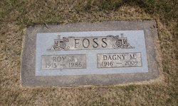
Roy J. Foss
| Birth | : | 22 Sep 1915 Renville County, North Dakota, USA |
| Death | : | Jul 1986 Minot, Ward County, North Dakota, USA |
| Burial | : | St. Nicholas's Cemetery, Rochester, Medway Unitary Authority, England |
| Coordinate | : | 51.3780081, 0.5021076 |
| Description | : | Roy Foss, 70, Sherwood, died Tuesday at a Minot hospital. His funeral will be Thursday at 3:30 p.m. at Evanger Lutheran Church northeast of Kenmare with burial in the church cemetery. He was born Sept. 22, 1915 near Tolley to Andrew and Olivia Foss and was reared in Grover Township, Renville County, farming with his family. He married Dagney Evanger, Nov. 7, 1939, at Mohall. They continued to farm in Prosperity Township, Renvllle County. He served on the Renville County Old Settlers Association Board and the Prosperity Township School Board. Survivors: wife; sons, Cecil, Coon Rapids, Minn., Ivan, Sherwood; daughters,... Read More |
frequently asked questions (FAQ):
-
Where is Roy J. Foss's memorial?
Roy J. Foss's memorial is located at: St. Nicholas's Cemetery, Rochester, Medway Unitary Authority, England.
-
When did Roy J. Foss death?
Roy J. Foss death on Jul 1986 in Minot, Ward County, North Dakota, USA
-
Where are the coordinates of the Roy J. Foss's memorial?
Latitude: 51.3780081
Longitude: 0.5021076
Family Members:
Parent
Spouse
Siblings

Children
Flowers:


Nearby Cemetories:
1. St. Nicholas's Cemetery
Rochester, Medway Unitary Authority, England
Coordinate: 51.3780081, 0.5021076
2. St. Margaret's Cemetery
Rochester, Medway Unitary Authority, England
Coordinate: 51.3777000, 0.5011600
3. Fort Pitt Military Cemetery
Rochester, Medway Unitary Authority, England
Coordinate: 51.3769790, 0.5114570
4. St Margaret Churchyard
Rochester, Medway Unitary Authority, England
Coordinate: 51.3849380, 0.4993630
5. Rochester Baptist Church
Rochester, Medway Unitary Authority, England
Coordinate: 51.3871570, 0.5052370
6. St Matthew Churchyard
Borstal, Medway Unitary Authority, England
Coordinate: 51.3736150, 0.4868020
7. Rochester Cathedral
Rochester, Medway Unitary Authority, England
Coordinate: 51.3889750, 0.5031160
8. Rochester Castle Moat Burial Ground
Rochester, Medway Unitary Authority, England
Coordinate: 51.3894140, 0.5024580
9. St Nicholas Churchyard
Rochester, Medway Unitary Authority, England
Coordinate: 51.3894170, 0.5035320
10. Chatham Unitarian Church
Chatham, Medway Unitary Authority, England
Coordinate: 51.3826090, 0.5195850
11. Chatham Maidstone Road Cemetery
Chatham, Medway Unitary Authority, England
Coordinate: 51.3703300, 0.5227600
12. Strood Cemetery
Strood, Medway Unitary Authority, England
Coordinate: 51.3900220, 0.4838640
13. St Mary Churchyard
Chatham, Medway Unitary Authority, England
Coordinate: 51.3874550, 0.5244280
14. Chatham Burial Ground
Chatham, Medway Unitary Authority, England
Coordinate: 51.3849900, 0.5272600
15. Chatham Palmerston Road Cemetery
Chatham, Medway Unitary Authority, England
Coordinate: 51.3678600, 0.5267300
16. St Nicholas with St Mary Churchyard
Strood, Medway Unitary Authority, England
Coordinate: 51.3959790, 0.4931350
17. Chatham Naval Memorial
Chatham, Medway Unitary Authority, England
Coordinate: 51.3836479, 0.5321670
18. All Saints Churchyard
Frindsbury, Medway Unitary Authority, England
Coordinate: 51.4004440, 0.5058970
19. Brompton War Memorial
Chatham, Medway Unitary Authority, England
Coordinate: 51.3932140, 0.5293660
20. St George Churchyard
Chatham, Medway Unitary Authority, England
Coordinate: 51.3974070, 0.5346770
21. Christ Church Cemetery
Chatham, Medway Unitary Authority, England
Coordinate: 51.3716730, 0.5462690
22. St. Augustine's Church
Gillingham, Medway Unitary Authority, England
Coordinate: 51.3745050, 0.5474930
23. St. Barnabas Church
Gillingham, Medway Unitary Authority, England
Coordinate: 51.3801400, 0.5505370
24. St. Michael and All Angels Churchyard
Cuxton, Medway Unitary Authority, England
Coordinate: 51.3714120, 0.4546760