
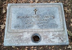
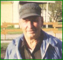
Roy Mitchel Smith
| Birth | : | 21 Apr 1910 South Dakota, USA |
| Death | : | 12 Apr 2002 California, USA |
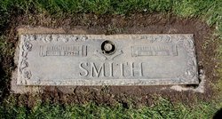
| Burial | : | Paso Robles District Cemetery, Paso Robles, San Luis Obispo County, USA |
| Coordinate | : | 35.6424700, -120.7035000 |
| Plot | : | 181 E 6 |
| Inscription | : | US Army, WW II |
frequently asked questions (FAQ):
-
Where is Roy Mitchel Smith's memorial?
Roy Mitchel Smith's memorial is located at: Paso Robles District Cemetery, Paso Robles, San Luis Obispo County, USA.
-
When did Roy Mitchel Smith death?
Roy Mitchel Smith death on 12 Apr 2002 in California, USA
-
Where are the coordinates of the Roy Mitchel Smith's memorial?
Latitude: 35.6424700
Longitude: -120.7035000
Family Members:
Parent
Siblings
Flowers:


Nearby Cemetories:
1. Paso Robles District Cemetery
Paso Robles, San Luis Obispo County, USA
Coordinate: 35.6424700, -120.7035000
2. Saint James Episcopal Church Inurnment Garden
Paso Robles, San Luis Obispo County, USA
Coordinate: 35.6283460, -120.6929780
3. Templeton Cemetery
Templeton, San Luis Obispo County, USA
Coordinate: 35.5714455, -120.7022095
4. Estrella Adobe Cemetery
Paso Robles, San Luis Obispo County, USA
Coordinate: 35.6975080, -120.6399460
5. San Marcos Mennonite Cemetery
San Luis Obispo County, USA
Coordinate: 35.6874570, -120.7995160
6. San Miguel District Cemetery
San Miguel, San Luis Obispo County, USA
Coordinate: 35.7392006, -120.7013550
7. Pleasant Valley Cemetery
San Miguel, San Luis Obispo County, USA
Coordinate: 35.7181892, -120.6228485
8. Mission San Miguel Cemetery
San Miguel, San Luis Obispo County, USA
Coordinate: 35.7452610, -120.6977370
9. Willow Creek Mennonite Cemetery
Wilson Corner, San Luis Obispo County, USA
Coordinate: 35.5890410, -120.8215860
10. Adelaida Cemetery
San Luis Obispo County, USA
Coordinate: 35.6563988, -120.8728027
11. Chapel of the Roses Cemetery
Atascadero, San Luis Obispo County, USA
Coordinate: 35.5027340, -120.6881430
12. Atascadero Pine Mountain Cemetery
Atascadero, San Luis Obispo County, USA
Coordinate: 35.4960835, -120.6565582
13. Adelaida Cemetery
Adelaida, San Luis Obispo County, USA
Coordinate: 35.5632085, -120.8956170
14. Creston Cemetery
Creston, San Luis Obispo County, USA
Coordinate: 35.5328640, -120.5121450
15. Dove Cemetery
San Luis Obispo County, USA
Coordinate: 35.4482231, -120.6344299
16. Hames Valley Cemetery
Bradley, Monterey County, USA
Coordinate: 35.8644660, -120.8505700
17. Cayucos-Morro Bay District Cemetery
Cayucos, San Luis Obispo County, USA
Coordinate: 35.4371986, -120.8850021
18. Santa Margarita Cemetery
Santa Margarita, San Luis Obispo County, USA
Coordinate: 35.3913994, -120.5880966
19. Porte Family Cemetery
San Simeon, San Luis Obispo County, USA
Coordinate: 35.6376400, -121.0379800
20. Shandon Cemetery
San Luis Obispo County, USA
Coordinate: 35.6693993, -120.3525009
21. Canet Cemetery
San Luis Obispo County, USA
Coordinate: 35.3522840, -120.7901660
22. St. Peter’s By-the-Sea Episcopal Church Memo
Morro Bay, San Luis Obispo County, USA
Coordinate: 35.3628700, -120.8467400
23. Saint Pauls Episcopal Church Memorial Garden
Cambria, San Luis Obispo County, USA
Coordinate: 35.5575200, -121.0757200
24. Santa Rosa Cemetery
Cambria, San Luis Obispo County, USA
Coordinate: 35.5662900, -121.0809300