

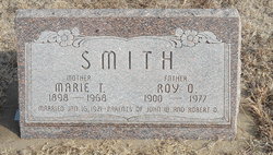
Roy Ova Smith
| Birth | : | 25 Aug 1900 Bosworth, Carroll County, Missouri, USA |
| Death | : | Nov 1977 Osborne County, Kansas, USA |
| Burial | : | Pleasant Hill Cemetery, Concordia, Cloud County, USA |
| Coordinate | : | 39.5583000, -97.6639023 |
| Plot | : | Block 8/60.01 |
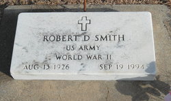
| Description | : | Roy O. Smith, 77, died at Park View Manor Nursing Home in Osborne. He was born August 25, 1900, in Bosworth, Missouri, to Philetus Smith and Clara D. McCollom. In January 1921 he was married to Marie Doyen, they had two sons, John and Robert. Mr. Smith worked over 40 years for the Union Pacific Railroad as a telegraph agent. He was a member of the Trinity Methodist Church, Masonic bodies and Isis Shrine. He is survived by his sons. Services will be at Trinity Methodist Church; burial at Pleasant Hill Cemetery. |
frequently asked questions (FAQ):
-
Where is Roy Ova Smith's memorial?
Roy Ova Smith's memorial is located at: Pleasant Hill Cemetery, Concordia, Cloud County, USA.
-
When did Roy Ova Smith death?
Roy Ova Smith death on Nov 1977 in Osborne County, Kansas, USA
-
Where are the coordinates of the Roy Ova Smith's memorial?
Latitude: 39.5583000
Longitude: -97.6639023
Family Members:
Parent
Spouse
Children
Flowers:


Nearby Cemetories:
1. Nazareth Convent Cemetery
Concordia, Cloud County, USA
Coordinate: 39.5614000, -97.6612000
2. Saint Concordia Cemetery
Concordia, Cloud County, USA
Coordinate: 39.5593800, -97.6503100
3. Hefner Cemetery
Cloud County, USA
Coordinate: 39.5393400, -97.7218400
4. Sibley Cemetery
Sibley Township, Cloud County, USA
Coordinate: 39.6096992, -97.6908035
5. Pleasant Hill Cemetery
Huscher, Cloud County, USA
Coordinate: 39.5093994, -97.6292038
6. Gotland Cemetery
Sibley Township, Cloud County, USA
Coordinate: 39.6091995, -97.6125031
7. West Branch Cemetery
Buffalo Township, Cloud County, USA
Coordinate: 39.5391998, -97.7457962
8. Saron Lutheran Cemetery
Sibley Township, Cloud County, USA
Coordinate: 39.6385994, -97.6511002
9. Murdock Family Cemetery
Cloud County, USA
Coordinate: 39.6386400, -97.6504800
10. Nelson Family Cemetery
Sibley Township, Cloud County, USA
Coordinate: 39.6366600, -97.7010600
11. Rice Cemetery
Rice, Cloud County, USA
Coordinate: 39.5614014, -97.5552979
12. Wilcox Cemetery
Cloud County, USA
Coordinate: 39.4925003, -97.7313995
13. Ezra Adkins Gravesite
Cloud County, USA
Coordinate: 39.6234500, -97.7372900
14. Fairview Cemetery
Buffalo Township, Cloud County, USA
Coordinate: 39.5889015, -97.7724991
15. Nelson Cemetery
Rice, Cloud County, USA
Coordinate: 39.5257988, -97.5410995
16. Minersville Cemetery
Talmo, Republic County, USA
Coordinate: 39.6568330, -97.6229250
17. Dutton Family Cemetery
Sibley Township, Cloud County, USA
Coordinate: 39.6419440, -97.7430560
18. Kindel Cemetery
Center Township, Cloud County, USA
Coordinate: 39.4519005, -97.6464005
19. Hall Cemetery
Cloud County, USA
Coordinate: 39.4455986, -97.7033005
20. Green Mound Cemetery
Rice, Cloud County, USA
Coordinate: 39.5248450, -97.5081630
21. Hollis Cemetery
Cloud County, USA
Coordinate: 39.6383018, -97.5361023
22. Walnut Grove Cemetery
Cloud County, USA
Coordinate: 39.5699997, -97.4993973
23. Morrison Cemetery
Center Township, Cloud County, USA
Coordinate: 39.4817009, -97.7975006
24. Zion Cemetery
Agenda, Republic County, USA
Coordinate: 39.6749992, -97.5939026