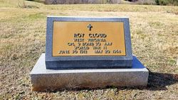
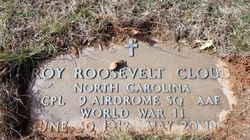
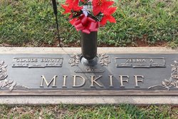
Roy Roosevelt Cloud
| Birth | : | 30 Jun 1912 Carroll County, Virginia, USA |
| Death | : | 20 May 1968 Guilford County, North Carolina, USA |
| Burial | : | Flat Ridge Baptist Church Cemetery, Cana, Carroll County, USA |
| Coordinate | : | 36.5867470, -80.6298910 |
| Inscription | : | WVA CPL 9 BOMB SQ AAF WW II; NC CPL 9 AIRDROME SQ AAF |
frequently asked questions (FAQ):
-
Where is Roy Roosevelt Cloud's memorial?
Roy Roosevelt Cloud's memorial is located at: Flat Ridge Baptist Church Cemetery, Cana, Carroll County, USA.
-
When did Roy Roosevelt Cloud death?
Roy Roosevelt Cloud death on 20 May 1968 in Guilford County, North Carolina, USA
-
Where are the coordinates of the Roy Roosevelt Cloud's memorial?
Latitude: 36.5867470
Longitude: -80.6298910
Family Members:
Parent
Spouse
Siblings
Children
Nearby Cemetories:
1. Flat Ridge Baptist Church Cemetery
Cana, Carroll County, USA
Coordinate: 36.5867470, -80.6298910
2. Westmoreland Cemetery
Cana, Carroll County, USA
Coordinate: 36.5850100, -80.6461990
3. Speas Family Cemetery
Cana, Carroll County, USA
Coordinate: 36.5724564, -80.6447983
4. Mount Bethel Moravian Graveyard
Cana, Carroll County, USA
Coordinate: 36.6053120, -80.6272700
5. Solid Rock Baptist Church Cemetery
Cana, Carroll County, USA
Coordinate: 36.5652400, -80.6357650
6. Glass Family Memorial Cemetery
Cana, Carroll County, USA
Coordinate: 36.5652280, -80.6357090
7. Epworth United Methodist Church Cemetery
Cana, Carroll County, USA
Coordinate: 36.5736110, -80.6536110
8. A.L. Jones Family Cemetery
Cana, Carroll County, USA
Coordinate: 36.5754410, -80.6561640
9. Allen Cemetery
Cana, Carroll County, USA
Coordinate: 36.6155280, -80.6192210
10. State Line Primitive Baptist Church Cemetery
Mount Airy, Surry County, USA
Coordinate: 36.5580000, -80.6117220
11. Harrold Cemetery
Carroll County, USA
Coordinate: 36.6199300, -80.6219970
12. Cana Baptist Church Cemetery
Cana, Carroll County, USA
Coordinate: 36.5920764, -80.6717347
13. Gunnell - Bowman - Fleming Cemetery
Ararat, Patrick County, USA
Coordinate: 36.5898540, -80.5866110
14. Primitive Baptist Church Of Jesus Christ Cemetery
Cana, Carroll County, USA
Coordinate: 36.5917320, -80.6737210
15. Willis Gap Baptist Church Cemetery
Ararat, Patrick County, USA
Coordinate: 36.5925140, -80.5850250
16. Wisler Cemetery
Cana, Carroll County, USA
Coordinate: 36.5933240, -80.6756550
17. Inscore Cemetery
Ararat, Patrick County, USA
Coordinate: 36.5988000, -80.5838000
18. Gunnell Family Cemetery
Ararat, Patrick County, USA
Coordinate: 36.6034190, -80.5852510
19. Noonkester Family Cemetery
Ararat, Patrick County, USA
Coordinate: 36.6019990, -80.5830940
20. Portis Cemetery
Ararat, Patrick County, USA
Coordinate: 36.6132460, -80.5890090
21. Oak Ridge Baptist Church Cemetery
Cana, Carroll County, USA
Coordinate: 36.5718760, -80.6800790
22. Montgomery Family Cemetery
Ararat, Patrick County, USA
Coordinate: 36.6239760, -80.5977920
23. Mount Carmel Baptist Church Cemetery
Mount Airy, Surry County, USA
Coordinate: 36.5432510, -80.6457214
24. Mountain View Primitive Baptist Church Cemetery
Ararat, Patrick County, USA
Coordinate: 36.6127720, -80.5827530

