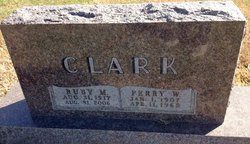
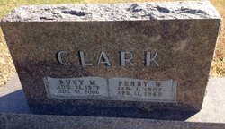
Ruby Mae McMillan Clark
| Birth | : | 31 Aug 1917 Blue Rapids, Marshall County, Kansas, USA |
| Death | : | 31 Aug 2006 Kansas, USA |
| Burial | : | Hollis Cemetery, Cloud County, USA |
| Coordinate | : | 39.6383018, -97.5361023 |
| Plot | : | D/5 |
| Description | : | Ruby M. Harries, 89, of Marysville, KS, died Thursday, August 31, 2006 at the Life Care Center of Seneca, in Seneca, KS. She is survived by two daughters, Lois Keefover of Aurora, CO and June Tebbutt of Seneca, and a son, Bill Clark, of Blue Rapids KS, 17 grandchildren and 27 great grandchildren. Published by Topeka Capital-Journal on Sep. 1, 2006. A celebration of life service will be 10:30 a.m. Saturday, September 2, 2006 at the United Methodist Church in Marysville, KS where she will lie in state one hour prior to the services. ... Read More |
frequently asked questions (FAQ):
-
Where is Ruby Mae McMillan Clark's memorial?
Ruby Mae McMillan Clark's memorial is located at: Hollis Cemetery, Cloud County, USA.
-
When did Ruby Mae McMillan Clark death?
Ruby Mae McMillan Clark death on 31 Aug 2006 in Kansas, USA
-
Where are the coordinates of the Ruby Mae McMillan Clark's memorial?
Latitude: 39.6383018
Longitude: -97.5361023
Family Members:
Flowers:
Nearby Cemetories:
1. Hollis Cemetery
Cloud County, USA
Coordinate: 39.6383018, -97.5361023
2. Zion Cemetery
Agenda, Republic County, USA
Coordinate: 39.6749992, -97.5939026
3. Beck Family Cemetery
Agenda, Republic County, USA
Coordinate: 39.6818000, -97.4863000
4. Union Cemetery
Wayne, Republic County, USA
Coordinate: 39.6977997, -97.5457993
5. Gotland Cemetery
Sibley Township, Cloud County, USA
Coordinate: 39.6091995, -97.6125031
6. Minersville Cemetery
Talmo, Republic County, USA
Coordinate: 39.6568330, -97.6229250
7. Walnut Grove Cemetery
Cloud County, USA
Coordinate: 39.5699997, -97.4993973
8. Rose Hill Cemetery
Wayne, Republic County, USA
Coordinate: 39.7111015, -97.5661011
9. Rice Cemetery
Rice, Cloud County, USA
Coordinate: 39.5614014, -97.5552979
10. Agenda Cemetery
Agenda, Republic County, USA
Coordinate: 39.6761017, -97.4336014
11. Murdock Family Cemetery
Cloud County, USA
Coordinate: 39.6386400, -97.6504800
12. Saron Lutheran Cemetery
Sibley Township, Cloud County, USA
Coordinate: 39.6385994, -97.6511002
13. Mount Hope Cemetery
Clyde, Cloud County, USA
Coordinate: 39.5969009, -97.4116974
14. Mount Calvary Cemetery
Clyde, Cloud County, USA
Coordinate: 39.5917015, -97.4143982
15. Frontier Cemetery
Belleville, Republic County, USA
Coordinate: 39.7400017, -97.5986023
16. Nelson Cemetery
Rice, Cloud County, USA
Coordinate: 39.5257988, -97.5410995
17. Green Mound Cemetery
Rice, Cloud County, USA
Coordinate: 39.5248450, -97.5081630
18. West Creek Cemetery
Belleville, Republic County, USA
Coordinate: 39.7041660, -97.6608930
19. Saint Concordia Cemetery
Concordia, Cloud County, USA
Coordinate: 39.5593800, -97.6503100
20. Sibley Cemetery
Sibley Township, Cloud County, USA
Coordinate: 39.6096992, -97.6908035
21. Nazareth Convent Cemetery
Concordia, Cloud County, USA
Coordinate: 39.5614000, -97.6612000
22. Pleasant View Cemetery
Ames, Cloud County, USA
Coordinate: 39.5346985, -97.4431000
23. Pleasant Hill Cemetery
Concordia, Cloud County, USA
Coordinate: 39.5583000, -97.6639023
24. Nelson Family Cemetery
Sibley Township, Cloud County, USA
Coordinate: 39.6366600, -97.7010600


