
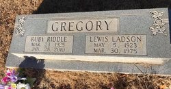
Ruby Riddle Gregory
| Birth | : | 25 Mar 1925 |
| Death | : | 28 Jan 2010 |
| Burial | : | Calvinia Cemetery, Calvinia, Namakwa District Municipality, South Africa |
| Coordinate | : | -31.4761889, 19.7780932 |
| Description | : | BUFFALO, SC Mrs. Ruby Riddle Gregory, 84, widow of Ladson Gregory, of 3559 Buffalo-West Springs Highway, Buffalo, died Thursday, January 28, 2010 at Spartanburg Regional Medical Center after a long illness. Mrs. Gregory was born in Spartanburg County on March 23, 1925, a daughter of the late Faber Riddle, Sr. and Millie Smith Riddle. She was a graduate of Union High School and a retired beautician, having operated Ruby's Beauty Shop. Mrs. Gregory was a member of Putman Baptist Church where she served as church organist for 55 years, and was a member of the Guiding Light Sunday School class. Surviving... Read More |
frequently asked questions (FAQ):
-
Where is Ruby Riddle Gregory's memorial?
Ruby Riddle Gregory's memorial is located at: Calvinia Cemetery, Calvinia, Namakwa District Municipality, South Africa.
-
When did Ruby Riddle Gregory death?
Ruby Riddle Gregory death on 28 Jan 2010 in
-
Where are the coordinates of the Ruby Riddle Gregory's memorial?
Latitude: -31.4761889
Longitude: 19.7780932
Family Members:
Spouse

Children
Flowers:


Nearby Cemetories:
1. Calvinia Cemetery
Calvinia, Namakwa District Municipality, South Africa
Coordinate: -31.4761889, 19.7780932
2. Hoogekraal Farm Cemetery
Calvinia, Namakwa District Municipality, South Africa
Coordinate: -31.4767098, 19.7783071
3. Plessis Street Cemetery
Calvinia, Namakwa District Municipality, South Africa
Coordinate: -31.4705481, 19.7643484
4. Nieuwoudtville Cemetery
Nieuwoudtville, Namakwa District Municipality, South Africa
Coordinate: -31.3760996, 19.1272025
5. British Anglo Boer War Memorial
Kompromise, Namakwa District Municipality, South Africa
Coordinate: -31.9052670, 20.2307500
6. Spitsberg Farm Cemetery
Loeriesfontein, Namakwa District Municipality, South Africa
Coordinate: -30.9217100, 19.5529100
7. Windkloof Street Cemetery
Loeriesfontein, Namakwa District Municipality, South Africa
Coordinate: -30.9528469, 19.4319591
8. Loeriesfontein Old Cemetery
Loeriesfontein, Namakwa District Municipality, South Africa
Coordinate: -30.9476587, 19.4351083
9. Loeriesfontein Cemetery
Loeriesfontein, Namakwa District Municipality, South Africa
Coordinate: -30.9451000, 19.4386830
10. Doringbos Cemetery
Cederberg, West Coast District Municipality, South Africa
Coordinate: -31.9750292, 19.2235993
11. Sevilla 135 Cemetery
Clanwilliam, West Coast District Municipality, South Africa
Coordinate: -32.0661255, 19.1273011
12. Vanrhynsdorp North Cemetery
Vanrhynsdorp, West Coast District Municipality, South Africa
Coordinate: -31.5954406, 18.7571635
13. NG Kerk - Vanrhynsdorp Gedenkmuur
Vanrhynsdorp, West Coast District Municipality, South Africa
Coordinate: -31.6087299, 18.7369811
14. Vanrhynsdorp South Cemetery
Vanrhynsdorp, West Coast District Municipality, South Africa
Coordinate: -31.6130650, 18.7354200
15. Wupperthal
Wupperthal, West Coast District Municipality, South Africa
Coordinate: -32.2761252, 19.2180976
16. Williston Cemetery
Williston, Namakwa District Municipality, South Africa
Coordinate: -31.3474721, 20.9063914
17. Williston Municipal Cemetery
Central Karoo District Municipality, South Africa
Coordinate: -31.3521678, 20.9088723
18. NG Kerk - Williston Kerkhof
Williston, Namakwa District Municipality, South Africa
Coordinate: -31.3409716, 20.9164241
19. Amandelboom Cemetery
Williston, Namakwa District Municipality, South Africa
Coordinate: -31.3423081, 20.9239760
20. Klawer Cemetery
Klawer, West Coast District Municipality, South Africa
Coordinate: -31.7793410, 18.6284070
21. St John's Anglican Cemetery
Clanwilliam, West Coast District Municipality, South Africa
Coordinate: -32.1789010, 18.8928590
22. NG Kerk - Clanwilliam Kerkhof
Clanwilliam, West Coast District Municipality, South Africa
Coordinate: -32.1804460, 18.8933760
23. Trawal Cemetery
West Coast District Municipality, South Africa
Coordinate: -31.8802609, 18.6369698
24. Vredendal North Cemetery
Vredendal, West Coast District Municipality, South Africa
Coordinate: -31.6387861, 18.5210770