
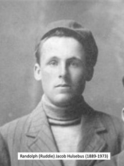

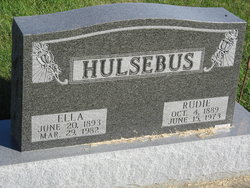
Rudolph Jacob “Rudie” Hulsebus
| Birth | : | 4 Oct 1889 Defiance, Shelby County, Iowa, USA |
| Death | : | 15 Jun 1973 Council Bluffs, Pottawattamie County, Iowa, USA |
| Burial | : | North Gundagai Cemetery, Gundagai, Cootamundra-Gundagai Regional Council, Australia |
| Coordinate | : | -35.0513900, 148.1119400 |
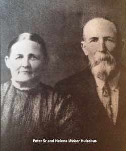
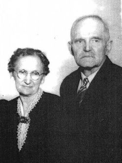
| Description | : | Rudolph Jacob Hulsebus was born Oct 4, 1889 on a farm south of Defiance. He was the son of Peter and Helena Weber Hulsebus and lived his entire life in the community. He died at the Jennie Edmundson Hospital in Council Bluffs on June 15 1973 at the age of 83. He was baptized in Defiance and he has been a lifetime member of the United Methodist Church there. In 1907, he moved with his family to a farm 1 mile north of Defiance and he has lived on this same farm since that time. In 1910 he... Read More |
frequently asked questions (FAQ):
-
Where is Rudolph Jacob “Rudie” Hulsebus's memorial?
Rudolph Jacob “Rudie” Hulsebus's memorial is located at: North Gundagai Cemetery, Gundagai, Cootamundra-Gundagai Regional Council, Australia.
-
When did Rudolph Jacob “Rudie” Hulsebus death?
Rudolph Jacob “Rudie” Hulsebus death on 15 Jun 1973 in Council Bluffs, Pottawattamie County, Iowa, USA
-
Where are the coordinates of the Rudolph Jacob “Rudie” Hulsebus's memorial?
Latitude: -35.0513900
Longitude: 148.1119400
Family Members:
Parent
Spouse
Siblings

Children
Flowers:


Nearby Cemetories:
1. North Gundagai Cemetery
Gundagai, Cootamundra-Gundagai Regional Council, Australia
Coordinate: -35.0513900, 148.1119400
2. Gundagai Lawn Cemetery and Columbarium Wall
Gundagai, Cootamundra-Gundagai Regional Council, Australia
Coordinate: -35.0505070, 148.1134450
3. South Gundagai Cemetery
Gundagai, Cootamundra-Gundagai Regional Council, Australia
Coordinate: -35.0964700, 148.0922890
4. Wagragobilly Cemetery
Darbalara, Cootamundra-Gundagai Regional Council, Australia
Coordinate: -35.0875240, 148.2117960
5. Coolac Cemetery
Coolac, Cootamundra-Gundagai Regional Council, Australia
Coordinate: -34.9316600, 148.1664400
6. Tumblong Cemetery
Tumblong, Cootamundra-Gundagai Regional Council, Australia
Coordinate: -35.1551470, 147.9999310
7. Nangus General Cemetery
Nangus, Cootamundra-Gundagai Regional Council, Australia
Coordinate: -35.0531510, 147.9029060
8. Adjungbilly Cemetery
Adjungbilly, Cootamundra-Gundagai Regional Council, Australia
Coordinate: -35.0905440, 148.3858500
9. Muttama Cemetery
Muttama, Cootamundra-Gundagai Regional Council, Australia
Coordinate: -34.8178460, 148.1230180
10. Cooba Cemetery
Cooba, Cootamundra-Gundagai Regional Council, Australia
Coordinate: -34.9499900, 147.8498100
11. Mundarlo Cemetery
Mundarlo, Cootamundra-Gundagai Regional Council, Australia
Coordinate: -35.0930800, 147.8169500
12. Mitta Mitta Anglican Cemetery
Mitta Mitta, Junee Shire, Australia
Coordinate: -34.8917820, 147.8526410
13. Jugiong Catholic
Jugiong, Hilltops Council, Australia
Coordinate: -34.8221590, 148.3467340
14. Jugiong Cemetery
Jugiong, Hilltops Council, Australia
Coordinate: -34.8221590, 148.3467340
15. Wantabadgery Cemetery
Wantabadgery, Junee Shire, Australia
Coordinate: -35.0548700, 147.7141440
16. Bethungra Cemetery
Bethungra, Junee Shire, Australia
Coordinate: -34.7631900, 147.8387300
17. Cootamundra General Cemetery
Cootamundra, Cootamundra-Gundagai Regional Council, Australia
Coordinate: -34.6331280, 148.0435500
18. Junee Cemetery
Junee, Junee Shire, Australia
Coordinate: -34.8792860, 147.6090210
19. Wallendbeen Cemetery
Wallendbeen, Cootamundra-Gundagai Regional Council, Australia
Coordinate: -34.5340990, 148.1525920
20. Junee Pioneer Cemetery
Junee, Junee Shire, Australia
Coordinate: -34.8250950, 147.5234380
21. Old Junee Cemetery
Old Junee, Junee Shire, Australia
Coordinate: -34.8288640, 147.5153160
22. Harden-Murrumburrah Cemetery
Murrumburrah, Hilltops Council, Australia
Coordinate: -34.5417750, 148.3273410
23. Stockinbingal Cemetery
Stockinbingal, Cootamundra-Gundagai Regional Council, Australia
Coordinate: -34.4900260, 147.8755720
24. Galong Cemetery
Galong, Hilltops Council, Australia
Coordinate: -34.5674060, 148.5600240