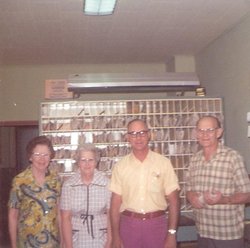
| Birth | : | 2 Sep 1911 Buffalo County, Nebraska, USA |
| Death | : | 15 Sep 2010 Holdrege, Phelps County, Nebraska, USA |
| Burial | : | Geraldine Cemetery, Geraldine, Timaru District, New Zealand |
| Coordinate | : | -44.0982600, 171.2407000 |
| Description | : | Ruth Agnes Anderson, 99, of Holdrege, formerly of Axtell, died Wednesday, Sept. 15, 2010, at Holdrege Memorial Homes. Ruth was born on September 2, 1911 on a farm northwest of Elm Creek in Buffalo County, Nebraska the third of four children born to Gilbert Adolph and Mary (Brodine) Englund. Most of her early life was spent on a farm north of Holdrege. She was confirmed June 13, 1926 at the Moses Hill Mission Church and baptized as an adult on January 29, 1966 in Buffalo, New York. Ruth attended rural school District #25 and graduated from Holdrege High School with... Read More |
frequently asked questions (FAQ):
-
Where is Ruth Agnes Englund Anderson's memorial?
Ruth Agnes Englund Anderson's memorial is located at: Geraldine Cemetery, Geraldine, Timaru District, New Zealand.
-
When did Ruth Agnes Englund Anderson death?
Ruth Agnes Englund Anderson death on 15 Sep 2010 in Holdrege, Phelps County, Nebraska, USA
-
Where are the coordinates of the Ruth Agnes Englund Anderson's memorial?
Latitude: -44.0982600
Longitude: 171.2407000
Family Members:
Parent
Spouse
Siblings
Flowers:
Nearby Cemetories:
1. Geraldine Cemetery
Geraldine, Timaru District, New Zealand
Coordinate: -44.0982600, 171.2407000
2. St. Anne's Churchyard
Geraldine, Timaru District, New Zealand
Coordinate: -44.0836111, 171.1994444
3. Woodbury Cemetery
Woodbury, Timaru District, New Zealand
Coordinate: -44.0360900, 171.2127000
4. Saint Aidan's Churchyard
Geraldine, Timaru District, New Zealand
Coordinate: -44.1544420, 171.0980340
5. Arundel Cemetery
Arundel, Timaru District, New Zealand
Coordinate: -43.9785690, 171.2838900
6. Temuka Cemetery
Temuka, Timaru District, New Zealand
Coordinate: -44.2499010, 171.3014390
7. Whareki Cemetery
Temuka, Timaru District, New Zealand
Coordinate: -44.2558600, 171.2734500
8. Cracroft Cemetery
Ruapuna, Ashburton District, New Zealand
Coordinate: -43.9341900, 171.2989500
9. Pleasant Point Cemetery
Pleasant Point, Timaru District, New Zealand
Coordinate: -44.2615490, 171.1237320
10. St David’s Anglican Churchyard
Mackenzie District, New Zealand
Coordinate: -44.1706380, 170.9887810
11. Hinds Cemetery
Hinds, Ashburton District, New Zealand
Coordinate: -44.0075580, 171.5735400
12. Church of the Holy Innocents Churchyard
Peel Forest, Timaru District, New Zealand
Coordinate: -43.8398520, 171.2471820
13. Ruapuna Cemetery
Ruapuna, Ashburton District, New Zealand
Coordinate: -43.8436110, 171.3680400
14. Fairlie Cemetery
Fairlie, Mackenzie District, New Zealand
Coordinate: -44.1075700, 170.8301500
15. Windermere Cemetery
Windermere, Ashburton District, New Zealand
Coordinate: -43.9874945, 171.6232358
16. Albury Cemetery
Albury, Mackenzie District, New Zealand
Coordinate: -44.2371220, 170.8736570
17. Burnett Family Cemetery
Cave, Timaru District, New Zealand
Coordinate: -44.3156830, 170.9457270
18. Timaru Cemetery
Timaru, Timaru District, New Zealand
Coordinate: -44.4122320, 171.2574270
19. Longbeach Estate Chapel
Longbeach, Ashburton District, New Zealand
Coordinate: -44.0941090, 171.6884504
20. Winslow Cemetery
Winslow, Ashburton District, New Zealand
Coordinate: -43.9576290, 171.6522810
21. Salisbury Park Crematorium
Timaru, Timaru District, New Zealand
Coordinate: -44.4292400, 171.2080200
22. Pareora West Cemetery
Pareora West, Timaru District, New Zealand
Coordinate: -44.4383120, 171.1343000
23. Waterton Cemetery
Eiffelton, Ashburton District, New Zealand
Coordinate: -44.0640000, 171.7260000
24. Upper Rangitata Cemetery
Rangitata, Timaru District, New Zealand
Coordinate: -43.7575112, 171.0907394


