

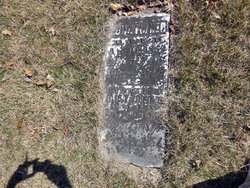
Ruth Conger Fisher
| Birth | : | 4 Nov 1788 |
| Death | : | 19 Feb 1857 |
| Burial | : | Winsell Cemetery, Fairfield, Jefferson County, USA |
| Coordinate | : | 40.9067001, -92.1247025 |
| Plot | : | Stone # 101 |
| Description | : | Note: maiden name "Conger" added to this memorial on April 11, 2015 per edit request. The parent relationship links are added to this memorial on this same date, but with the caution that both of the memorials for her father and mother were created as burial unknowns - it is hoped that family researchers will determine where they were buried and have the memorials changed accordingly. Sister of David S Conger. |
frequently asked questions (FAQ):
-
Where is Ruth Conger Fisher's memorial?
Ruth Conger Fisher's memorial is located at: Winsell Cemetery, Fairfield, Jefferson County, USA.
-
When did Ruth Conger Fisher death?
Ruth Conger Fisher death on 19 Feb 1857 in
-
Where are the coordinates of the Ruth Conger Fisher's memorial?
Latitude: 40.9067001
Longitude: -92.1247025
Family Members:
Parent
Spouse
Siblings
Children

Flowers:


Nearby Cemetories:
1. Winsell Cemetery
Fairfield, Jefferson County, USA
Coordinate: 40.9067001, -92.1247025
2. Iowaville Cemetery
Selma, Van Buren County, USA
Coordinate: 40.8861008, -92.1628036
3. Rominger Cemetery
Batavia, Jefferson County, USA
Coordinate: 40.9379000, -92.1503000
4. Mount Moriah Cemetery
Douds, Van Buren County, USA
Coordinate: 40.8710000, -92.0860000
5. Fell Cemetery
Libertyville, Jefferson County, USA
Coordinate: 40.9375000, -92.0772018
6. Passmore Cemetery
Van Buren County, USA
Coordinate: 40.8608017, -92.1549988
7. Chief Black Hawk Burial Site
Floris, Davis County, USA
Coordinate: 40.8852780, -92.1972220
8. Zion Lutheran Cemetery
Douds, Van Buren County, USA
Coordinate: 40.8563000, -92.0664000
9. Brethren Cemetery
Batavia, Jefferson County, USA
Coordinate: 40.9768000, -92.1240000
10. Des Moines River Cemetery
Wapello County, USA
Coordinate: 40.9463000, -92.2042000
11. Boyer Family Cemetery
Leando, Van Buren County, USA
Coordinate: 40.8333560, -92.1112885
12. Hem Cemetery
Davis County, USA
Coordinate: 40.8389015, -92.1785965
13. Eldon Cemetery
Eldon, Wapello County, USA
Coordinate: 40.9296989, -92.2249985
14. Morgan Burial Plot
Des Moines Township, Jefferson County, USA
Coordinate: 40.9837160, -92.0964340
15. Leando Cemetery
Douds, Van Buren County, USA
Coordinate: 40.8269005, -92.0883026
16. Ellsworth Cemetery
Ashland, Wapello County, USA
Coordinate: 40.9500182, -92.2251806
17. McCleary Cemetery
Jefferson County, USA
Coordinate: 40.9892006, -92.0805969
18. Bethel Cemetery
Birmingham, Van Buren County, USA
Coordinate: 40.8967018, -92.0056000
19. Fite Hill Cemetery
Davis County, USA
Coordinate: 40.8972414, -92.2474037
20. Bethlehem Cemetery
Davis County, USA
Coordinate: 40.8699989, -92.2399979
21. Batavia Cemetery
Batavia, Jefferson County, USA
Coordinate: 40.9977080, -92.1661100
22. Glasgow Cemetery
Davis County, USA
Coordinate: 40.8856010, -92.2497025
23. Jefferson County Poor Farm Cemetery
Libertyville, Jefferson County, USA
Coordinate: 40.9416900, -91.9996200
24. Ashland Cemetery
Ashland, Wapello County, USA
Coordinate: 40.9570000, -92.2410000