
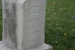
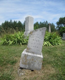
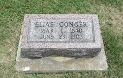
Elias Gregory Conger
| Birth | : | 18 Jul 1806 Greene County, Pennsylvania, USA |
| Death | : | 18 Aug 1895 |
| Burial | : | All Saints Churchyard, Belton, North Lincolnshire Unitary Authority, England |
| Coordinate | : | 53.5478600, -0.8199200 |
| Inscription | : | 89 years 1 month |
frequently asked questions (FAQ):
-
Where is Elias Gregory Conger's memorial?
Elias Gregory Conger's memorial is located at: All Saints Churchyard, Belton, North Lincolnshire Unitary Authority, England.
-
When did Elias Gregory Conger death?
Elias Gregory Conger death on 18 Aug 1895 in
-
Where are the coordinates of the Elias Gregory Conger's memorial?
Latitude: 53.5478600
Longitude: -0.8199200
Family Members:
Parent
Spouse
Siblings
Children
Flowers:


Nearby Cemetories:
1. All Saints Churchyard
Belton, North Lincolnshire Unitary Authority, England
Coordinate: 53.5478600, -0.8199200
2. St Andrew Churchyard
Epworth, North Lincolnshire Unitary Authority, England
Coordinate: 53.5256450, -0.8231740
3. Epworth Municipal Cemetery
Epworth, North Lincolnshire Unitary Authority, England
Coordinate: 53.5206600, -0.8239000
4. Baptist Burial Ground
West Butterwick, North Lincolnshire Unitary Authority, England
Coordinate: 53.5432720, -0.7423210
5. St Mary the Virgin Churchyard
West Butterwick, North Lincolnshire Unitary Authority, England
Coordinate: 53.5426407, -0.7412120
6. St John The Baptist Churchyard Extension
Burringham, North Lincolnshire Unitary Authority, England
Coordinate: 53.5708230, -0.7439800
7. St Oswald Churchyard
Althorpe, North Lincolnshire Unitary Authority, England
Coordinate: 53.5765570, -0.7408910
8. Owston Ferry Cemetery
Owston Ferry, North Lincolnshire Unitary Authority, England
Coordinate: 53.4966300, -0.7827500
9. St Martin's Churchyard
Owston Ferry, North Lincolnshire Unitary Authority, England
Coordinate: 53.4933920, -0.7886380
10. St Oswald Churchyard
Crowle, North Lincolnshire Unitary Authority, England
Coordinate: 53.6077330, -0.8353940
11. St. Nicholas' Churchyard
Haxey, North Lincolnshire Unitary Authority, England
Coordinate: 53.4896400, -0.8489650
12. Crowle Cemetery
Crowle, North Lincolnshire Unitary Authority, England
Coordinate: 53.6090660, -0.8285680
13. Crowle Baptist Church
Crowle, North Lincolnshire Unitary Authority, England
Coordinate: 53.6093970, -0.8317350
14. St Pancras Church
Wroot, North Lincolnshire Unitary Authority, England
Coordinate: 53.5158350, -0.9209990
15. Woodlands Cemetery and Crematorium
Scunthorpe, North Lincolnshire Unitary Authority, England
Coordinate: 53.5810900, -0.6744900
16. St Bartholomews Churchyard
Eastoft, North Lincolnshire Unitary Authority, England
Coordinate: 53.6397700, -0.7823500
17. St Marks Church
Amcotts, North Lincolnshire Unitary Authority, England
Coordinate: 53.6166950, -0.7088900
18. Holy Trinity Churchyard
Messingham, North Lincolnshire Unitary Authority, England
Coordinate: 53.5323250, -0.6583030
19. Laughton Cemetery
Laughton, West Lindsey District, England
Coordinate: 53.4681287, -0.7228939
20. All Saints Churchyard
Laughton, West Lindsey District, England
Coordinate: 53.4656600, -0.7224400
21. Thorne Cemetery
Thorne, Metropolitan Borough of Doncaster, England
Coordinate: 53.6084100, -0.9572000
22. Hatfield Woodhouse
Hatfield, Metropolitan Borough of Doncaster, England
Coordinate: 53.5736500, -0.9855500
23. St. Nicholas Churchyard
Thorne, Metropolitan Borough of Doncaster, England
Coordinate: 53.6116500, -0.9580000
24. St Peter Ad Vincula Church
Bottesford, North Lincolnshire Unitary Authority, England
Coordinate: 53.5533120, -0.6448410