

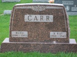
Ruth Dawson Carr
| Birth | : | 25 Dec 1890 |
| Death | : | 24 May 1962 |
| Burial | : | High Prairie Cemetery, Leavenworth County, USA |
| Coordinate | : | 39.2724991, -95.0168991 |
| Plot | : | Section 7, Row 4 |
| Description | : | Published in The Rochester News-Sentinel Friday, May 25, 1962 Ruth Carr Mrs. Ruth CARR, 71, R.R. 3, Argos, a native of Akron, died at 5:30 p.m. Thursday in Parkview hospital, Plymouth, following an illness of 10 months. She had lived in the Argos vicinity for 40 years. Born Dec. 25, 1890, she was the daughter of Samuel and Martha STINSTON DAWSON. She was married in Fulton county April 11, 1910 to Ray CARR, a former Fulton county commissioner, who died Dec. 23, 1949. Mrs. Carr was a member of the Jordan Baptist church and the Green Township Home Economics club. Surviving are two daughters, Mrs. Charles... Read More |
frequently asked questions (FAQ):
-
Where is Ruth Dawson Carr's memorial?
Ruth Dawson Carr's memorial is located at: High Prairie Cemetery, Leavenworth County, USA.
-
When did Ruth Dawson Carr death?
Ruth Dawson Carr death on 24 May 1962 in
-
Where are the coordinates of the Ruth Dawson Carr's memorial?
Latitude: 39.2724991
Longitude: -95.0168991
Family Members:
Parent
Spouse
Siblings
Children
Flowers:


Nearby Cemetories:
1. Little Stranger Cemetery
Leavenworth County, USA
Coordinate: 39.2453003, -94.9741974
2. Sunset Memory Gardens
Leavenworth, Leavenworth County, USA
Coordinate: 39.2999992, -94.9653015
3. Bethel Cemetery
Springdale, Leavenworth County, USA
Coordinate: 39.2846985, -95.0777969
4. Schrimpf Family Cemetery
Lowemont, Leavenworth County, USA
Coordinate: 39.2353400, -95.0632500
5. Starns Cemetery
Lansing, Leavenworth County, USA
Coordinate: 39.2435989, -94.9488983
6. Campbell Cemetery
Jarbalo, Leavenworth County, USA
Coordinate: 39.2303600, -95.0753400
7. Mary Ackley Gravesite
Leavenworth County, USA
Coordinate: 39.3317300, -95.0402100
8. Greenwood Cemetery
Leavenworth, Leavenworth County, USA
Coordinate: 39.2881012, -94.9385986
9. Sons of Truth Cemetery
Leavenworth, Leavenworth County, USA
Coordinate: 39.3302994, -94.9775009
10. Mount Aurora Cemetery (Defunct)
Leavenworth, Leavenworth County, USA
Coordinate: 39.2971800, -94.9364600
11. Sully Family Cemetery
Leavenworth, Leavenworth County, USA
Coordinate: 39.3226790, -94.9571080
12. Leavenworth High School Killed/Missing In Action
Leavenworth, Leavenworth County, USA
Coordinate: 39.2955685, -94.9307293
13. Mount Olivet Cemetery
Easton, Leavenworth County, USA
Coordinate: 39.3385010, -95.0582962
14. Fall Creek Cemetery
Jarbalo, Leavenworth County, USA
Coordinate: 39.2242012, -95.0883026
15. Mount Calvary Cemetery
Leavenworth, Leavenworth County, USA
Coordinate: 39.2653008, -94.9214020
16. Isaac Gruber Gravesite
Kickapoo Township, Leavenworth County, USA
Coordinate: 39.3349400, -94.9585400
17. United States Penitentiary Cemetery
Leavenworth, Leavenworth County, USA
Coordinate: 39.3311996, -94.9511566
18. Saint Thomas Cemetery
Springdale, Leavenworth County, USA
Coordinate: 39.2597008, -95.1192017
19. Old Kelly Burial Grounds
Leavenworth, Leavenworth County, USA
Coordinate: 39.2047100, -94.9586200
20. Stranger Creek Cemetery
Easton, Leavenworth County, USA
Coordinate: 39.3211100, -95.1016700
21. Friends Church Cemetery
Springdale, Leavenworth County, USA
Coordinate: 39.2532800, -95.1237100
22. Mount Olivet Cemetery
Leavenworth, Leavenworth County, USA
Coordinate: 39.2811012, -94.9036026
23. Saint Paul Episcopal Church Columbarium
Leavenworth, Leavenworth County, USA
Coordinate: 39.3196400, -94.9185300
24. Sparks Cemetery
Easton, Leavenworth County, USA
Coordinate: 39.2958336, -95.1355591