

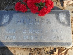
Ruth Emily Semple Hughes
| Birth | : | 30 Oct 1908 Corydon, Wayne County, Iowa, USA |
| Death | : | 26 Jul 1980 Kearney, Buffalo County, Nebraska, USA |
| Burial | : | Davis Cemetery, Davis, Yolo County, USA |
| Coordinate | : | 38.5550003, -121.7260971 |
| Description | : | Wife of Chester Ross "Ross" Hughes (1902-1967). Mother of two children and grandmother. Daughter of Harry W. Semple and Hollie B. (Clark) Semple. Obituary from the Woodland Daily Democrat on July 26, 1980 is as follows: Woodland, Yolo, California: Ruth Emily Hughes - Funeral services will be held Wednesday at 8 am at the Davis Funeral Chapel for Ruth Emily Hughes, 71, who died Saturday in Kearney, Nebraska while visiting relatives. Mrs. Hughes suffered a heart attack. Mrs. Hughes was a native of Corydon, Iowa and lived in the Ft. Jones area of California for 36... Read More |
frequently asked questions (FAQ):
-
Where is Ruth Emily Semple Hughes's memorial?
Ruth Emily Semple Hughes's memorial is located at: Davis Cemetery, Davis, Yolo County, USA.
-
When did Ruth Emily Semple Hughes death?
Ruth Emily Semple Hughes death on 26 Jul 1980 in Kearney, Buffalo County, Nebraska, USA
-
Where are the coordinates of the Ruth Emily Semple Hughes's memorial?
Latitude: 38.5550003
Longitude: -121.7260971
Family Members:
Parent

Spouse
Siblings
Flowers:


Nearby Cemetories:
1. Davis Cemetery
Davis, Yolo County, USA
Coordinate: 38.5550003, -121.7260971
2. Episcopal Church of Saint Martin Columbarium
Davis, Yolo County, USA
Coordinate: 38.5488870, -121.7611850
3. Tremont Cemetery
Dixon, Solano County, USA
Coordinate: 38.4940987, -121.7043991
4. Saint Joseph Cemetery
Woodland, Yolo County, USA
Coordinate: 38.6694400, -121.7842120
5. Woodland Cemetery
Woodland, Yolo County, USA
Coordinate: 38.6711006, -121.7846985
6. Dixon Cemetery
Dixon, Solano County, USA
Coordinate: 38.4354553, -121.8227005
7. Monument Hill Memorial Park
Woodland, Yolo County, USA
Coordinate: 38.6781020, -121.8566400
8. Sunset Hill Cemetery
Sacramento, Sacramento County, USA
Coordinate: 38.5608000, -121.5037300
9. Masonic Lawn Cemetery
Sacramento, Sacramento County, USA
Coordinate: 38.5604720, -121.5032600
10. Odd Fellows Lawn Cemetery and Mausoleum
Sacramento, Sacramento County, USA
Coordinate: 38.5585000, -121.5011000
11. Sacramento City Cemetery
Sacramento, Sacramento County, USA
Coordinate: 38.5636864, -121.5009537
12. National Shrine of Our Lady of Guadalupe Crypt
Sacramento, Sacramento County, USA
Coordinate: 38.5704800, -121.5014400
13. Buddhist Church of Sacramento Nokotsudo
Sacramento, Sacramento County, USA
Coordinate: 38.5639300, -121.4978400
14. Sacramento Valley National Cemetery
Dixon, Solano County, USA
Coordinate: 38.4167800, -121.8754000
15. California State Capitol
Sacramento, Sacramento County, USA
Coordinate: 38.5760994, -121.4931488
16. Holy Ascension Russian Orthodox Cemetery
Sacramento, Sacramento County, USA
Coordinate: 38.5846212, -121.4936736
17. Saint Joseph Cemetery
Sacramento, Sacramento County, USA
Coordinate: 38.5574989, -121.4835968
18. Cacheville Cemetery
Yolo, Yolo County, USA
Coordinate: 38.7378300, -121.8090200
19. Pho Minh Temple Columbarium
Sacramento, Sacramento County, USA
Coordinate: 38.5340100, -121.4769000
20. Trinity Episcopal Cathedral Columbarium
Sacramento, Sacramento County, USA
Coordinate: 38.5705500, -121.4723770
21. Winters Cemetery
Winters, Yolo County, USA
Coordinate: 38.5256004, -121.9777985
22. Gordon Family Cemetery
Esparto, Yolo County, USA
Coordinate: 38.6966060, -121.9151540
23. Saint Rose Cemetery (Defunct)
Sacramento, Sacramento County, USA
Coordinate: 38.5208015, -121.4672012
24. New Helvetia Cemetery (Defunct)
Sacramento, Sacramento County, USA
Coordinate: 38.5731600, -121.4639900