


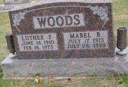
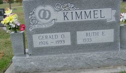
Ruth Estella Woods Kimmel
| Birth | : | 25 Jan 1935 Osceola, Clarke County, Iowa, USA |
| Death | : | 21 May 2008 Carlisle, Warren County, Iowa, USA |
| Burial | : | Oakdale Baptist Church Cemetery, Spencer, Rowan County, USA |
| Coordinate | : | 35.6981710, -80.4208690 |
| Inscription | : | wed Nov 3 1956 |
| Description | : | Ruth Estella Kimmel was the eldest of four daughters born to Luther Woods and Mabel Ruth (Whitehead) Woods. She was born January 25, 1935 in Clarke County, Iowa and passed from this life May 21, 2008 at Carlisle Care Center at 73 years of age. Ruth attended country schools and graduated from Osceola High School. She was united in marriage to Gerald Olin Kimmel on November 3, 1956 at Indianola, Iowa and spent her lifetime in the Osceola area. Ruth worked for Snowdons from 1954 until they closed in 1980; she then worked at Leann Factory. Ruth enjoyed crafts of all kinds... Read More |
frequently asked questions (FAQ):
-
Where is Ruth Estella Woods Kimmel's memorial?
Ruth Estella Woods Kimmel's memorial is located at: Oakdale Baptist Church Cemetery, Spencer, Rowan County, USA.
-
When did Ruth Estella Woods Kimmel death?
Ruth Estella Woods Kimmel death on 21 May 2008 in Carlisle, Warren County, Iowa, USA
-
Where are the coordinates of the Ruth Estella Woods Kimmel's memorial?
Latitude: 35.6981710
Longitude: -80.4208690
Family Members:
Parent

Spouse
Flowers:


Nearby Cemetories:
1. Oakdale Baptist Church Cemetery
Spencer, Rowan County, USA
Coordinate: 35.6981710, -80.4208690
2. New Hope AME Zion Church Cemetery
Spencer, Rowan County, USA
Coordinate: 35.6971390, -80.4203330
3. Jerusalem Baptist Church Cemetery
Spencer, Rowan County, USA
Coordinate: 35.6975970, -80.4137470
4. Christ Lutheran Church Cemetery
Spencer, Rowan County, USA
Coordinate: 35.6924150, -80.4234570
5. Calvary Lutheran Church Columbarium
Spencer, Rowan County, USA
Coordinate: 35.6906720, -80.4373860
6. Smith Cemetery
Salisbury, Rowan County, USA
Coordinate: 35.6812220, -80.4087140
7. Yadkin Baptist Church Cemetery
Salisbury, Rowan County, USA
Coordinate: 35.7178078, -80.4020233
8. Beulah Land Baptist Church Cemetery
Rowan County, USA
Coordinate: 35.6644600, -80.4020480
9. Ardis Chapel AME Zion Church Cemetery
Salisbury, Rowan County, USA
Coordinate: 35.7038918, -80.4660721
10. Calvary Baptist Church Cemetery
Salisbury, Rowan County, USA
Coordinate: 35.7240510, -80.4600340
11. Old Lutheran Church Cemetery
Salisbury, Rowan County, USA
Coordinate: 35.6699867, -80.4633102
12. Oak Grove Freedman's Cemetery
Salisbury, Rowan County, USA
Coordinate: 35.6697700, -80.4693000
13. Old English Cemetery
Salisbury, Rowan County, USA
Coordinate: 35.6699982, -80.4697037
14. First Baptist Church of Salisbury Columbarium
Salisbury, Rowan County, USA
Coordinate: 35.6710000, -80.4710400
15. Saint John's Lutheran Columbarium and Garden
Salisbury, Rowan County, USA
Coordinate: 35.6688340, -80.4715850
16. Presbyterian Session House Burial Ground
Salisbury, Rowan County, USA
Coordinate: 35.6690550, -80.4720260
17. Smith Grove Baptist Church Cemetery
Linwood, Davidson County, USA
Coordinate: 35.7491580, -80.4205750
18. Old Lebanon Methodist Church Cemetery
Salisbury, Rowan County, USA
Coordinate: 35.7248800, -80.4752750
19. Bethel United Methodist Church Cemetery
Trading Ford, Rowan County, USA
Coordinate: 35.6847992, -80.3591003
20. Memorial Park Cemetery
Salisbury, Rowan County, USA
Coordinate: 35.6784680, -80.4800140
21. New Zion Baptist Church Cemetery
Salisbury, Rowan County, USA
Coordinate: 35.6420059, -80.4205017
22. Dixonville Cemetery
Salisbury, Rowan County, USA
Coordinate: 35.6599998, -80.4721985
23. Salisbury National Cemetery
Salisbury, Rowan County, USA
Coordinate: 35.6612282, -80.4746475
24. Trading Ford Church Cemetery
Salisbury, Rowan County, USA
Coordinate: 35.6780210, -80.3546110