
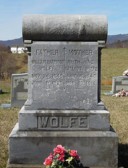
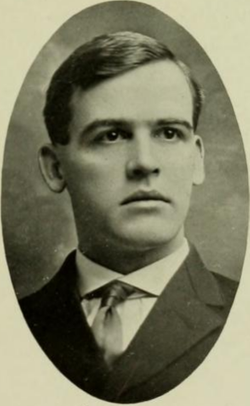
Ruth Jane Callaway Wolfe
| Birth | : | 16 Jun 1845 Yadkin County, North Carolina, USA |
| Death | : | 13 Mar 1918 Thurmond, Surry County, North Carolina, USA |
| Burial | : | All Saints Churchyard, Hawstead, St Edmundsbury Borough, England |
| Coordinate | : | 52.1998300, 0.7143900 |
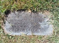
| Description | : | Daughter of Ferrell and Jane (Mackie) Callaway. |
frequently asked questions (FAQ):
-
Where is Ruth Jane Callaway Wolfe's memorial?
Ruth Jane Callaway Wolfe's memorial is located at: All Saints Churchyard, Hawstead, St Edmundsbury Borough, England.
-
When did Ruth Jane Callaway Wolfe death?
Ruth Jane Callaway Wolfe death on 13 Mar 1918 in Thurmond, Surry County, North Carolina, USA
-
Where are the coordinates of the Ruth Jane Callaway Wolfe's memorial?
Latitude: 52.1998300
Longitude: 0.7143900
Family Members:
Parent
Spouse

Siblings

Children

Flowers:


Nearby Cemetories:
1. All Saints Churchyard
Hawstead, St Edmundsbury Borough, England
Coordinate: 52.1998300, 0.7143900
2. St Peter's Churchyard
Nowton, St Edmundsbury Borough, England
Coordinate: 52.2109220, 0.7257590
3. Church of St. Thomas à Becket
Great Whelnetham, St Edmundsbury Borough, England
Coordinate: 52.2003200, 0.7468860
4. Whepstead Baptist Churchyard
Whepstead, St Edmundsbury Borough, England
Coordinate: 52.1886000, 0.6873500
5. Whepstead Cemetery
Whepstead, St Edmundsbury Borough, England
Coordinate: 52.1922830, 0.6806830
6. St. Petronilla Churchyard
Whepstead, St Edmundsbury Borough, England
Coordinate: 52.1919020, 0.6799150
7. St Mary Magdalene Churchyard
Little Whelnetham, St Edmundsbury Borough, England
Coordinate: 52.2062540, 0.7628880
8. St. Nicholas Churchyard
Stanningfield, St Edmundsbury Borough, England
Coordinate: 52.1734800, 0.7436500
9. Saint Leonard's Churchyard
Horringer, St Edmundsbury Borough, England
Coordinate: 52.2250540, 0.6750640
10. All Saints Churchyard
Bradfield Combust, St Edmundsbury Borough, England
Coordinate: 52.1814730, 0.7663800
11. Bradfield Combust Methodist Churchyard
Bradfield Combust, St Edmundsbury Borough, England
Coordinate: 52.1727200, 0.7602400
12. St Nicholas Churchyard
Rushbrooke, St Edmundsbury Borough, England
Coordinate: 52.2193810, 0.7704070
13. St. Mary's Churchyard
Bury St Edmunds, St Edmundsbury Borough, England
Coordinate: 52.2424630, 0.7172480
14. St. Mary's Churchyard
Ickworth, St Edmundsbury Borough, England
Coordinate: 52.2184440, 0.6516990
15. St. Andrew's Churchyard
Brockley, St Edmundsbury Borough, England
Coordinate: 52.1675880, 0.6659170
16. St. Edmundsbury Cathedral
Bury St Edmunds, St Edmundsbury Borough, England
Coordinate: 52.2439340, 0.7170190
17. Bury St Edmunds Abbey
Bury St Edmunds, St Edmundsbury Borough, England
Coordinate: 52.2441060, 0.7192360
18. Bury St Edmunds Cemetery
Bury St Edmunds, St Edmundsbury Borough, England
Coordinate: 52.2438030, 0.7014930
19. All Saints Churchyard
Lawshall, Babergh District, England
Coordinate: 52.1552780, 0.7239140
20. Saint George Churchyard
Bradfield St George, St Edmundsbury Borough, England
Coordinate: 52.2045960, 0.7894600
21. Saint Clare
Bradfield St Clare, St Edmundsbury Borough, England
Coordinate: 52.1854050, 0.7920340
22. Brockley Baptist Chapel
Brockley, St Edmundsbury Borough, England
Coordinate: 52.1588990, 0.6650810
23. All Saints Churchyard
Rede, St Edmundsbury Borough, England
Coordinate: 52.1721960, 0.6379560
24. All Saints Churchyard
Chedburgh, St Edmundsbury Borough, England
Coordinate: 52.1864480, 0.6260630