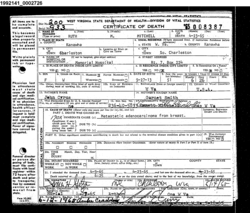
Ruth Marie Cyrus Mitchell
| Birth | : | 27 Sep 1913 Cabell County, West Virginia, USA |
| Death | : | 23 Apr 1965 Charleston, Kanawha County, West Virginia, USA |
| Burial | : | Saint Johns Cemetery, Carrollton, Carroll County, USA |
| Coordinate | : | 38.6769000, -85.1786900 |
| Description | : | Daughter of John Elijah Cyrus & Anna Garnet Smith. Wife of Emmett Leroy Mitchell. Burial: 27 Apr 1965, Arthur Cem. |
frequently asked questions (FAQ):
-
Where is Ruth Marie Cyrus Mitchell's memorial?
Ruth Marie Cyrus Mitchell's memorial is located at: Saint Johns Cemetery, Carrollton, Carroll County, USA.
-
When did Ruth Marie Cyrus Mitchell death?
Ruth Marie Cyrus Mitchell death on 23 Apr 1965 in Charleston, Kanawha County, West Virginia, USA
-
Where are the coordinates of the Ruth Marie Cyrus Mitchell's memorial?
Latitude: 38.6769000
Longitude: -85.1786900
Family Members:
Parent
Spouse
Flowers:
Nearby Cemetories:
1. Saint Johns Cemetery
Carrollton, Carroll County, USA
Coordinate: 38.6769000, -85.1786900
2. City Cemetery
Carrollton, Carroll County, USA
Coordinate: 38.6781600, -85.1815260
3. Methodist Church Cemetery
Carrollton, Carroll County, USA
Coordinate: 38.6805190, -85.1821880
4. Chapel of Memories Mausoleum
Carrollton, Carroll County, USA
Coordinate: 38.6783400, -85.1715500
5. Carrollton IOOF Cemetery
Carrollton, Carroll County, USA
Coordinate: 38.6783360, -85.1715460
6. Butler Family Cemetery
Carrollton, Carroll County, USA
Coordinate: 38.6710090, -85.1651880
7. Gaunt Cemetery
Carrollton, Carroll County, USA
Coordinate: 38.6842040, -85.1621560
8. Cain Cemetery
Lamb, Switzerland County, USA
Coordinate: 38.6918280, -85.1764990
9. Ash Cemetery
Lamb, Switzerland County, USA
Coordinate: 38.6939180, -85.1891040
10. Masterson Cemetery
Carroll County, USA
Coordinate: 38.6879000, -85.1509700
11. Gap Hill Cemetery
Carrollton, Carroll County, USA
Coordinate: 38.6749992, -85.1464005
12. Mound Hill Cemetery
Carrollton, Carroll County, USA
Coordinate: 38.6570600, -85.2028500
13. Sample Family Farm Cemetery
Lamb, Switzerland County, USA
Coordinate: 38.7050180, -85.1936290
14. May Cemetery
Carroll County, USA
Coordinate: 38.6461560, -85.2047790
15. Carroll County Poor Farm Cemetery
Carroll County, USA
Coordinate: 38.6688880, -85.1308010
16. McKay Cemetery #1
Brooksburg, Jefferson County, USA
Coordinate: 38.7065800, -85.2120790
17. Coghill Cemetery
Carrollton, Carroll County, USA
Coordinate: 38.6604500, -85.2280130
18. Kings Ridge Cemetery
Carroll County, USA
Coordinate: 38.6738740, -85.2324670
19. McKay Cemetery
Vevay, Switzerland County, USA
Coordinate: 38.7160988, -85.1567001
20. Craig Township Cemetery
Vevay, Switzerland County, USA
Coordinate: 38.7055290, -85.1368170
21. Carraco Cemetery
Carroll County, USA
Coordinate: 38.6527730, -85.1275140
22. Shaw Cemetery
Vevay, Switzerland County, USA
Coordinate: 38.7198380, -85.1510170
23. Gale Cemetery
Brooksburg, Jefferson County, USA
Coordinate: 38.7104170, -85.2236390
24. Cove Hill Cemetery
Carroll County, USA
Coordinate: 38.6257600, -85.1908200


