
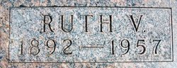

Ruth Verena Davis Anderson
| Birth | : | 11 Nov 1892 Holton, Jackson County, Kansas, USA |
| Death | : | 17 Apr 1957 Toppenish, Yakima County, Washington, USA |
| Burial | : | Onida Cemetery, Onida, Sully County, USA |
| Coordinate | : | 44.7147000, -100.0650000 |
| Plot | : | Section D |
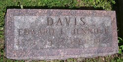
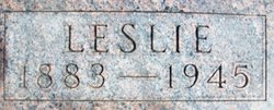
| Description | : | the following information was provided by Find A Grave contributor, Jen: Family History: Ruth Davis Anderson was the second child of Edward J. Davis and Jennie Dredge Davis. She was born November 11, 1892 in the Banner Community. She graduated from Banner High School and for a time at Campbell College. She was a teacher in the rural schools of Jackson County. She married Leslie Anderson on the 26 December, 1917 and they made their home near Holton, Ks. In 1935, they moved to Forest City, Mo. and in 1938 moved with their five... Read More |
frequently asked questions (FAQ):
-
Where is Ruth Verena Davis Anderson's memorial?
Ruth Verena Davis Anderson's memorial is located at: Onida Cemetery, Onida, Sully County, USA.
-
When did Ruth Verena Davis Anderson death?
Ruth Verena Davis Anderson death on 17 Apr 1957 in Toppenish, Yakima County, Washington, USA
-
Where are the coordinates of the Ruth Verena Davis Anderson's memorial?
Latitude: 44.7147000
Longitude: -100.0650000
Family Members:
Parent

Spouse
Siblings
Children
Flowers:


Nearby Cemetories:
1. Onida Cemetery
Onida, Sully County, USA
Coordinate: 44.7147000, -100.0650000
2. Holy Rosary Cemetery
Agar, Sully County, USA
Coordinate: 44.8380000, -100.0616000
3. Schreiber Cemetery
Agar, Sully County, USA
Coordinate: 44.8821983, -100.1196976
4. Pleasant Hill Cemetery
Blunt, Hughes County, USA
Coordinate: 44.5135994, -100.0156021
5. Pleasant Cemetery
Sully County, USA
Coordinate: 44.6927986, -99.7568970
6. Okobojo Cemetery
Sully County, USA
Coordinate: 44.6568985, -100.3647003
7. Byron Township Cemetery
Blunt, Hughes County, USA
Coordinate: 44.4979200, -100.1904700
8. Blair Cemetery
Sully County, USA
Coordinate: 44.8027992, -100.4199982
9. Petro Family Cemetery
Gettysburg, Potter County, USA
Coordinate: 44.9706825, -100.2259903
10. Sacred Heart Cemetery
Gettysburg, Potter County, USA
Coordinate: 44.9982986, -99.9377975
11. Medicine Hill Cemetery
Harrold, Hughes County, USA
Coordinate: 44.5116997, -99.7453003
12. Copp Cemetery
Potter County, USA
Coordinate: 44.9118935, -99.7358236
13. Saint John Catholic Cemetery
Harrold, Hughes County, USA
Coordinate: 44.5127983, -99.7335968
14. Gettysburg Memorial Cemetery
Gettysburg Township, Potter County, USA
Coordinate: 45.0208146, -99.9898400
15. Canning Cemetery
Hughes County, USA
Coordinate: 44.3986890, -100.0278460
16. Gettysburg Cemetery
Gettysburg, Potter County, USA
Coordinate: 45.0149994, -99.9199982
17. Forest City Cemetery (Defunct)
Forest City, Potter County, USA
Coordinate: 45.0239900, -100.2667000
18. Mount Calvary Cemetery
Pierre, Hughes County, USA
Coordinate: 44.4197006, -100.3557968
19. Spring Lake Cemetery
Hyde County, USA
Coordinate: 44.7942009, -99.5610962
20. Riverside Cemetery
Pierre, Hughes County, USA
Coordinate: 44.3608017, -100.3071976
21. Scotty Philip Cemetery
Fort Pierre, Stanley County, USA
Coordinate: 44.4019012, -100.4036026
22. Fort Pierre Chouteau Cemetery
Fort Pierre, Stanley County, USA
Coordinate: 44.3908700, -100.3878300
23. South Dakota State Capitol Grounds
Pierre, Hughes County, USA
Coordinate: 44.3660100, -100.3448000
24. Lebanon Cemetery
Lebanon, Potter County, USA
Coordinate: 45.0635500, -99.7768400