
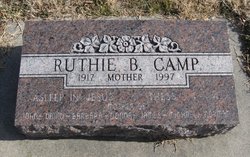
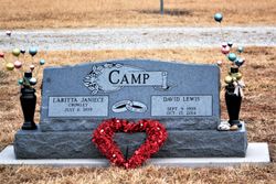
Ruthie Berniece Wilcoxen Camp
| Birth | : | 8 Sep 1917 Arkansas, USA |
| Death | : | 17 Feb 1997 Cedar Vale, Chautauqua County, Kansas, USA |
| Burial | : | East Midway Cemetery, La Grange, Lewis County, USA |
| Coordinate | : | 40.1585999, -91.8283005 |
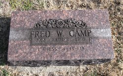
| Description | : | MRS. RUTH B. CAMP CEDAR VALE — Ruth Berniece Camp, 79, of the Cedar Vale Nursing Center, formerly of Winfield, died Feb. 17, 1997, in Cedar Vale Community Hospital. Services will be held at 10;30 a.m. Thursday in Green lawn Cemetery at Grenola. Friends may call at Wheeler Funeral Home of Cedar Vale from 10 a.m. to 8 p.m. Wednesday. A memorial has been established with the Cedar Vale Nursing Center. Camp was born Sept. 8, 1917, in Paragould, Ark., a daughter of David and Bertha Willcoxen. On Aug. 14, 1937, she married Fred W. Camp in Howard. In 1958 they moved to Winfield after... Read More |
frequently asked questions (FAQ):
-
Where is Ruthie Berniece Wilcoxen Camp's memorial?
Ruthie Berniece Wilcoxen Camp's memorial is located at: East Midway Cemetery, La Grange, Lewis County, USA.
-
When did Ruthie Berniece Wilcoxen Camp death?
Ruthie Berniece Wilcoxen Camp death on 17 Feb 1997 in Cedar Vale, Chautauqua County, Kansas, USA
-
Where are the coordinates of the Ruthie Berniece Wilcoxen Camp's memorial?
Latitude: 40.1585999
Longitude: -91.8283005
Family Members:
Parent
Spouse
Siblings
Children
Flowers:


Nearby Cemetories:
1. East Midway Cemetery
La Grange, Lewis County, USA
Coordinate: 40.1585999, -91.8283005
2. Midway Cemetery
Lewistown, Lewis County, USA
Coordinate: 40.1586600, -91.8284300
3. Buckner Cemetery
La Belle, Lewis County, USA
Coordinate: 40.1183870, -91.8456910
4. Morris Cemetery
Lewis County, USA
Coordinate: 40.1917000, -91.7707977
5. Cecil Cemetery
Lewis County, USA
Coordinate: 40.2178001, -91.8155975
6. La Belle Cemetery
La Belle, Lewis County, USA
Coordinate: 40.1278000, -91.9083023
7. Lewistown Cemetery
Lewistown, Lewis County, USA
Coordinate: 40.0904390, -91.8138960
8. Sharpe-Hinkson Cemetery
Lewis County, USA
Coordinate: 40.1494061, -91.9229145
9. Ewalt Cemetery
Dickerson Township, Lewis County, USA
Coordinate: 40.1046810, -91.7636490
10. Deer Ridge Cemetery
Deer Ridge, Lewis County, USA
Coordinate: 40.2110170, -91.8955230
11. Williamstown Cemetery
Williamstown, Lewis County, USA
Coordinate: 40.2402992, -91.8099976
12. Bondurant Cemetery
La Belle, Lewis County, USA
Coordinate: 40.1810989, -91.9432983
13. Jarvis Cemetery
Monticello, Lewis County, USA
Coordinate: 40.1347008, -91.7133026
14. Little Mountain Cemetery
Monticello, Lewis County, USA
Coordinate: 40.1227330, -91.7130170
15. Mount Pleasant Cemetery
La Belle, Lewis County, USA
Coordinate: 40.1260986, -91.9496994
16. Fee-Carlin Cemetery
Lewis County, USA
Coordinate: 40.2514040, -91.7816640
17. Providence Cemetery
Williamstown, Lewis County, USA
Coordinate: 40.2419600, -91.7567400
18. Mount Salem Cemetery
Lewis County, USA
Coordinate: 40.2143090, -91.9377570
19. Bangert Cemetery
Lewis County, USA
Coordinate: 40.0694008, -91.7418976
20. Zion Hill Cemetery
Monticello, Lewis County, USA
Coordinate: 40.2166730, -91.7000890
21. Baker Cemetery
Williamstown, Lewis County, USA
Coordinate: 40.2385180, -91.7220780
22. Graves Cemetery
Lewis County, USA
Coordinate: 40.1567001, -91.6744003
23. Triplett Family Cemetery
Knox County, USA
Coordinate: 40.1181900, -91.9777800
24. Crain Family Farm Cemetery
Highland Township, Lewis County, USA
Coordinate: 40.0493010, -91.7568180