
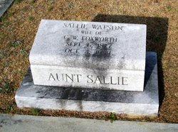
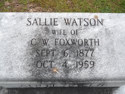
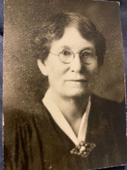
Sallie Watson Foxworth
| Birth | : | 6 Sep 1877 Dillon County, South Carolina, USA |
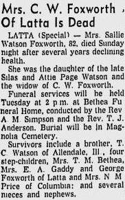
| Death | : | 4 Oct 1959 Latta, Dillon County, South Carolina, USA |
| Burial | : | Martiny Township Cemetery, Martiny Township, Mecosta County, USA |
| Coordinate | : | 43.6852989, -85.3097000 |
| Inscription | : | Aunt Sallie |
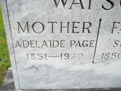
| Description | : | Daughter of Silas and Adelaide Page Watson, wife of Chesley William Foxworth. On August 27, 1951 Sallie applied for admission to the Confederate Home for the service of her late husband C. W. Foxworth in Company H, First Regiment, Rifles. |
frequently asked questions (FAQ):
-
Where is Sallie Watson Foxworth's memorial?
Sallie Watson Foxworth's memorial is located at: Martiny Township Cemetery, Martiny Township, Mecosta County, USA.
-
When did Sallie Watson Foxworth death?
Sallie Watson Foxworth death on 4 Oct 1959 in Latta, Dillon County, South Carolina, USA
-
Where are the coordinates of the Sallie Watson Foxworth's memorial?
Latitude: 43.6852989
Longitude: -85.3097000
Family Members:
Parent
Spouse
Siblings

Flowers:


Nearby Cemetories:
1. Martiny Township Cemetery
Martiny Township, Mecosta County, USA
Coordinate: 43.6852989, -85.3097000
2. Rodney Cemetery
Rodney, Mecosta County, USA
Coordinate: 43.6703491, -85.3264923
3. Chippewa Lake Cemetery
Chippewa Township, Mecosta County, USA
Coordinate: 43.7494011, -85.2900009
4. Mount Hope Cemetery
Mecosta, Mecosta County, USA
Coordinate: 43.6260986, -85.2406006
5. 160th Avenue South Cemetery
Big Rapids, Mecosta County, USA
Coordinate: 43.7436111, -85.4038889
6. Dye Cemetery
Mecosta, Mecosta County, USA
Coordinate: 43.6646004, -85.1864929
7. Eaton Cemetery
Barryton, Mecosta County, USA
Coordinate: 43.7564011, -85.2202988
8. Pine Plains Cemetery
Big Rapids, Mecosta County, USA
Coordinate: 43.6680984, -85.4436035
9. Sparks Cemetery
Chippewa Township, Mecosta County, USA
Coordinate: 43.7724991, -85.2442017
10. 21 Mile South Cemetery
Grant Center, Mecosta County, USA
Coordinate: 43.7713000, -85.3875000
11. 21 Mile North Cemetery
Grant Center, Mecosta County, USA
Coordinate: 43.7710000, -85.3885000
12. Olin Cemetery
Stanwood, Mecosta County, USA
Coordinate: 43.5879000, -85.3719500
13. Morgan Cemetery
Wheatland Township, Mecosta County, USA
Coordinate: 43.6150017, -85.1932983
14. Pioneer Cemetery
Grant Township, Mecosta County, USA
Coordinate: 43.8005981, -85.3439026
15. Church Cemetery
Chippewa Township, Mecosta County, USA
Coordinate: 43.8058300, -85.2662240
16. Saint Andrews Episcopal Church Columbarium
Big Rapids, Mecosta County, USA
Coordinate: 43.6946130, -85.4835020
17. Saint Michaels Cemetery
Remus, Mecosta County, USA
Coordinate: 43.5959587, -85.1854782
18. Morton Township Cemetery
Mecosta, Mecosta County, USA
Coordinate: 43.5710983, -85.2249985
19. Brown Cemetery
Barryton, Mecosta County, USA
Coordinate: 43.7663994, -85.1682968
20. Highland View Cemetery
Big Rapids, Mecosta County, USA
Coordinate: 43.7032318, -85.4905319
21. Flake Cemetery
Barryton, Mecosta County, USA
Coordinate: 43.7372017, -85.1280975
22. Quigley Cemetery
Deerfield Township, Mecosta County, USA
Coordinate: 43.5536003, -85.3930969
23. Strong Cemetery
Sheridan Township, Mecosta County, USA
Coordinate: 43.7108002, -85.1117020
24. Stanwood Cemetery
Stanwood, Mecosta County, USA
Coordinate: 43.5769691, -85.4444885