

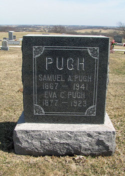
Samuel Atchison Pugh
| Birth | : | 17 Oct 1867 Ray County, Missouri, USA |
| Death | : | 11 Jul 1941 Grape Grove Township, Ray County, Missouri, USA |
| Burial | : | Goulburn Old Cemetery, Goulburn, Goulburn Mulwaree Council, Australia |
| Coordinate | : | -34.7444690, 149.7378160 |
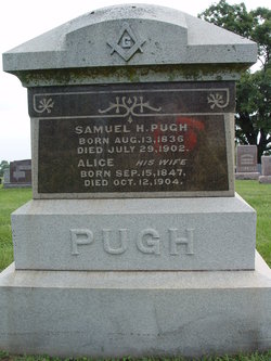
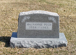
| Description | : | Samuel Atchison Pugh was a son of Samuel Henry/Hampton Pugh and Alice Wall Pugh. He had six siblings. Samuel Atchison Pugh married first to Eva C. Joy. Samuel Atchison Pugh married second to Nannie UNKNOWN. Samuel Atchison Pugh was 73 years, 8 months and 24 days old at the time of his death. |
frequently asked questions (FAQ):
-
Where is Samuel Atchison Pugh's memorial?
Samuel Atchison Pugh's memorial is located at: Goulburn Old Cemetery, Goulburn, Goulburn Mulwaree Council, Australia.
-
When did Samuel Atchison Pugh death?
Samuel Atchison Pugh death on 11 Jul 1941 in Grape Grove Township, Ray County, Missouri, USA
-
Where are the coordinates of the Samuel Atchison Pugh's memorial?
Latitude: -34.7444690
Longitude: 149.7378160
Family Members:
Parent

Spouse
Siblings
Children
Flowers:


Nearby Cemetories:
1. Goulburn Old Cemetery
Goulburn, Goulburn Mulwaree Council, Australia
Coordinate: -34.7444690, 149.7378160
2. Saint Saviours Anglican Cemetery
Goulburn, Goulburn Mulwaree Council, Australia
Coordinate: -34.7406960, 149.7432970
3. Goulburn Jewish Cemetery
Goulburn, Goulburn Mulwaree Council, Australia
Coordinate: -34.7551950, 149.7433550
4. Goulburn General Cemetery
Goulburn, Goulburn Mulwaree Council, Australia
Coordinate: -34.7442800, 149.7541200
5. Saint Saviours Cathedral Churchyard
Goulburn, Goulburn Mulwaree Council, Australia
Coordinate: -34.7531700, 149.7159700
6. Kenmore Roman Catholic Cemetery
Goulburn, Goulburn Mulwaree Council, Australia
Coordinate: -34.7244290, 149.7319710
7. Sts Peter & Paul Old Cathedral
Goulburn, Goulburn Mulwaree Council, Australia
Coordinate: -34.7556340, 149.7150370
8. Kenmore Mental Hospital Cemetery
Kenmore, Goulburn Mulwaree Council, Australia
Coordinate: -34.7187600, 149.7554470
9. St Patricks College (now Trinity Catholic College)
Goulburn, Goulburn Mulwaree Council, Australia
Coordinate: -34.7492240, 149.6969980
10. St. Andrew's Cemetery
Tirrannaville, Goulburn Mulwaree Council, Australia
Coordinate: -34.8181980, 149.6833340
11. Thurlow Methodist Church
Baw Baw, Goulburn Mulwaree Council, Australia
Coordinate: -34.7086590, 149.6179610
12. St Johns Anglican Churchyard
Towrang, Goulburn Mulwaree Council, Australia
Coordinate: -34.6956160, 149.8507090
13. Merrilla Cemetery
Goulburn, Goulburn Mulwaree Council, Australia
Coordinate: -34.7486220, 149.5993750
14. St James Anglican Cemetery
Pomeroy, Goulburn Mulwaree Council, Australia
Coordinate: -34.7488140, 149.5993110
15. St. Mary Cemetery
Yarra, Goulburn Mulwaree Council, Australia
Coordinate: -34.7973480, 149.6142910
16. Merrilla Methodist Cemetery
Merrilla, Goulburn Mulwaree Council, Australia
Coordinate: -34.7428100, 149.5785790
17. Komungla General Cemetery
Komungla, Goulburn Mulwaree Council, Australia
Coordinate: -34.8784540, 149.6404940
18. Mummell Catholic cemetery
Mummel, Goulburn Mulwaree Council, Australia
Coordinate: -34.6680260, 149.5499320
19. Murrel Cemetery
Mummel, Goulburn Mulwaree Council, Australia
Coordinate: -34.6680600, 149.5498400
20. Parkesbourne Methodist Cemetery
Parkesbourne, Goulburn Mulwaree Council, Australia
Coordinate: -34.7588220, 149.5222900
21. Marulan Anglican Cemetery
Marulan, Goulburn Mulwaree Council, Australia
Coordinate: -34.7318400, 149.9817200
22. Christ Church Anglican Churchyard
Bungonia, Goulburn Mulwaree Council, Australia
Coordinate: -34.8590005, 149.9432472
23. Marulan Catholic Cemetery
Marulan, Goulburn Mulwaree Council, Australia
Coordinate: -34.7281400, 149.9862120
24. Bungonia Cemetery
Bungonia, Goulburn Mulwaree Council, Australia
Coordinate: -34.8632150, 149.9422700