
| Birth | : | 21 Apr 1785 Alexandria, Grafton County, New Hampshire, USA |
| Death | : | 14 May 1867 Charlestown, Suffolk County, Massachusetts, USA |
| Burial | : | Phipps Street Burying Ground, Charlestown, Suffolk County, USA |
| Coordinate | : | 42.3766300, -71.0673000 |
| Plot | : | TOMB 12 - ADAMS & FERRIN |
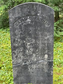
| Inscription | : | AE 82 y, 0 m, 23 d |
| Description | : | Suggested edit: Excerpted from Captain Jonathan Farren of Amesbury, Massachusetts and Some of His Descendants by Frank Myer Ferrin, p. 90, published 1941: Ferrin Street, Charlestown, was named for Samuel Ferrin... He was prosperous and genial, and the nieces and nephews always enjoyed visits at his home on Ferrin Street. A niece of Samuel remembers most pleasantly her visits in Charlestown. She mentions a fine tree in their garden called the "Tree of Heaven." She also said that the bands from the Navy Yard would serenade the Ferrins at different times. Samuel Ferrin was one of the selectmen of Charlestown... Read More |
frequently asked questions (FAQ):
-
Where is Samuel Ferrin's memorial?
Samuel Ferrin's memorial is located at: Phipps Street Burying Ground, Charlestown, Suffolk County, USA.
-
When did Samuel Ferrin death?
Samuel Ferrin death on 14 May 1867 in Charlestown, Suffolk County, Massachusetts, USA
-
Where are the coordinates of the Samuel Ferrin's memorial?
Latitude: 42.3766300
Longitude: -71.0673000
Family Members:
Parent
Spouse

Siblings
Children
Flowers:


Nearby Cemetories:
1. Phipps Street Burying Ground
Charlestown, Suffolk County, USA
Coordinate: 42.3766300, -71.0673000
2. Bunker Hill Burying Ground
Charlestown, Suffolk County, USA
Coordinate: 42.3789300, -71.0621200
3. Bunker Hill Monument
Charlestown, Suffolk County, USA
Coordinate: 42.3762360, -71.0607300
4. Saint Francis de Sales Cemetery
Charlestown, Suffolk County, USA
Coordinate: 42.3815420, -71.0658620
5. Charlestown Revolutionary War Memorial
Charlestown, Suffolk County, USA
Coordinate: 42.3745800, -71.0601800
6. Copp's Hill Burying Ground
Boston, Suffolk County, USA
Coordinate: 42.3670100, -71.0560800
7. Christ Church Cemetery
Boston, Suffolk County, USA
Coordinate: 42.3664900, -71.0545200
8. Kings Chapel Burying Ground
Boston, Suffolk County, USA
Coordinate: 42.3583340, -71.0600370
9. Granary Burying Ground
Boston, Suffolk County, USA
Coordinate: 42.3572400, -71.0613500
10. Trinity Church Tombs (Defunct)
Boston, Suffolk County, USA
Coordinate: 42.3549300, -71.0597500
11. Central Burying Ground
Boston, Suffolk County, USA
Coordinate: 42.3526300, -71.0659500
12. Milk Row Cemetery
Somerville, Middlesex County, USA
Coordinate: 42.3816300, -71.1020100
13. Cocoanut Grove Fire Memorial
Boston, Suffolk County, USA
Coordinate: 42.3499600, -71.0681900
14. Old South Church
Boston, Suffolk County, USA
Coordinate: 42.3500500, -71.0779000
15. Garden Cemetery
Chelsea, Suffolk County, USA
Coordinate: 42.3905983, -71.0330963
16. Bennington Street Cemetery
East Boston, Suffolk County, USA
Coordinate: 42.3814300, -71.0213000
17. Cathedral of the Holy Cross Crypt
Boston, Suffolk County, USA
Coordinate: 42.3408200, -71.0697400
18. South Burying Ground
Boston, Suffolk County, USA
Coordinate: 42.3382600, -71.0741000
19. Old Burying Ground
Cambridge, Middlesex County, USA
Coordinate: 42.3752930, -71.1196840
20. University Lutheran Memorial Garden
Cambridge, Middlesex County, USA
Coordinate: 42.3719200, -71.1200700
21. Temple Ohabei Shalom Cemetery
East Boston, Suffolk County, USA
Coordinate: 42.3827900, -71.0145700
22. Elm Street British Soldier Burial Site
Somerville, Middlesex County, USA
Coordinate: 42.3910900, -71.1185300
23. Saint Matthews Cemetery (Defunct)
South Boston, Suffolk County, USA
Coordinate: 42.3379940, -71.0497180
24. Bell Rock Cemetery
Malden, Middlesex County, USA
Coordinate: 42.4179800, -71.0718400