
Samuel Hall
| Birth | : | 24 Oct 1656 |
| Death | : | 30 Aug 1716 |
| Burial | : | Old Mission Cemetery, Wichita, Sedgwick County, USA |
| Coordinate | : | 37.7243996, -97.2964020 |
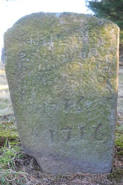
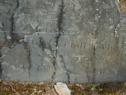
| Inscription | : | Here Lyes the body of Samuel Hall who Dyed In Ye 60 Year of his age August 30 1716 1716 |
| Description | : | Samuel was born in Rehoboth, Plymouth Colony. His parents were Edward Hall and ???, both of Rehoboth, MA Samuel married Abigail Pratt on 3 January 1683 in Taunton, Plymouth Colony. |
frequently asked questions (FAQ):
-
Where is Samuel Hall's memorial?
Samuel Hall's memorial is located at: Old Mission Cemetery, Wichita, Sedgwick County, USA.
-
When did Samuel Hall death?
Samuel Hall death on 30 Aug 1716 in
-
Where are the coordinates of the Samuel Hall's memorial?
Latitude: 37.7243996
Longitude: -97.2964020
Family Members:

Flowers:


Nearby Cemetories:
1. Old Mission Cemetery
Wichita, Sedgwick County, USA
Coordinate: 37.7243996, -97.2964020
2. Old Mission Mausoleum
Wichita, Sedgwick County, USA
Coordinate: 37.7242600, -97.2967400
3. Mission Chapel Mausoleum
Wichita, Sedgwick County, USA
Coordinate: 37.7231200, -97.2955100
4. Wichita Park Cemetery and Mausoleum
Wichita, Sedgwick County, USA
Coordinate: 37.7277985, -97.2960968
5. Wichita Hebrew Cemetery
Wichita, Sedgwick County, USA
Coordinate: 37.7201004, -97.2798004
6. White Chapel Memorial Gardens
Wichita, Sedgwick County, USA
Coordinate: 37.7162018, -97.2806015
7. Maple Grove Cemetery
Wichita, Sedgwick County, USA
Coordinate: 37.7036018, -97.2949982
8. Highland Cemetery
Wichita, Sedgwick County, USA
Coordinate: 37.7028008, -97.3007965
9. Temple Emanuel Cemetery
Wichita, Sedgwick County, USA
Coordinate: 37.7014000, -97.3008000
10. Saint James Episcopal Church Columbarium
Wichita, Sedgwick County, USA
Coordinate: 37.6865600, -97.2930000
11. East Heights United Methodist Memorial Garden
Wichita, Sedgwick County, USA
Coordinate: 37.6854100, -97.2845500
12. Shirley Tilford Memorial Garden
Wichita, Sedgwick County, USA
Coordinate: 37.6942700, -97.3359600
13. Saint Stephen's Episcopal Church Columbarium
Wichita, Sedgwick County, USA
Coordinate: 37.6999272, -97.2505590
14. Saint Johns Episcopal Church Columbarium
Wichita, Sedgwick County, USA
Coordinate: 37.6918950, -97.3339670
15. Calvary Cemetery
Wichita, Sedgwick County, USA
Coordinate: 37.6781006, -97.2949982
16. Mount Saint Mary Convent Cemetery
Wichita, Sedgwick County, USA
Coordinate: 37.6704000, -97.2904000
17. Ascension Cemetery
Bel Aire, Sedgwick County, USA
Coordinate: 37.7675018, -97.2533035
18. Lutheran Cemetery
Wichita, Sedgwick County, USA
Coordinate: 37.7664986, -97.2443008
19. Greenwich Cemetery
Wichita, Sedgwick County, USA
Coordinate: 37.7518997, -97.2266998
20. Kensington Gardens Cemetery
Wichita, Sedgwick County, USA
Coordinate: 37.7230988, -97.2040024
21. Pierpont Cemetery
Sedgwick County, USA
Coordinate: 37.7011400, -97.2077500
22. Kechi Township Cemetery
Park City, Sedgwick County, USA
Coordinate: 37.8022003, -97.3000031
23. Lakeview Cemetery & Mausoleum
Wichita, Sedgwick County, USA
Coordinate: 37.7086601, -97.1978989
24. Adorers of The Blood of Christ Convent Cemetery
Wichita, Sedgwick County, USA
Coordinate: 37.6677700, -97.3787800