

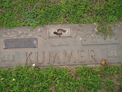
Samuel Kummer
| Birth | : | 21 Feb 1888 Duncan, Platte County, Nebraska, USA |
| Death | : | 11 Sep 1966 Columbus, Platte County, Nebraska, USA |
| Burial | : | All Saints Churchyard, Childwall, Metropolitan Borough of Liverpool, England |
| Coordinate | : | 53.3952880, -2.8816030 |
| Plot | : | unknown |
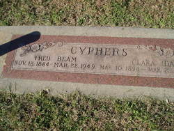
| Description | : | He was born Feb. 21, 1888 at Duncan, the son of Wilhelm and Lisette Eisenmann Kummer. He received his education in Dist.37 of Platte county and on April 13, 1915 married Mathilda Odermatt. He farmed near St. Edward and later was employed for 27 years by Loup River Public Power District. He was retired for the past nine years. Surviving are his wife, Mathilda, one daughter, Mrs. Joe (Mary) Schmidt, Flushing, N.Y., and one sister, Mrs. Clara Cyphers, Columbus.. He was preceded in death by his parents, two brothers, Jacob and Albert of Duncan, two sisters, Mrs. Albert (Mary)... Read More |
frequently asked questions (FAQ):
-
Where is Samuel Kummer's memorial?
Samuel Kummer's memorial is located at: All Saints Churchyard, Childwall, Metropolitan Borough of Liverpool, England.
-
When did Samuel Kummer death?
Samuel Kummer death on 11 Sep 1966 in Columbus, Platte County, Nebraska, USA
-
Where are the coordinates of the Samuel Kummer's memorial?
Latitude: 53.3952880
Longitude: -2.8816030
Family Members:
Parent

Spouse
Siblings
Flowers:


Nearby Cemetories:
1. All Saints Churchyard
Childwall, Metropolitan Borough of Liverpool, England
Coordinate: 53.3952880, -2.8816030
2. Calderstones Park
Liverpool, Metropolitan Borough of Liverpool, England
Coordinate: 53.3817419, -2.8956218
3. Broadgreen Jewish Cemetery
Liverpool, Metropolitan Borough of Liverpool, England
Coordinate: 53.4101320, -2.8977320
4. All Hallows Churchyard
Mossley Hill, Metropolitan Borough of Liverpool, England
Coordinate: 53.3808740, -2.9039930
5. St. Peter's Churchyard
Woolton, Metropolitan Borough of Liverpool, England
Coordinate: 53.3759310, -2.8693390
6. St. Mary's Churchyard
Woolton, Metropolitan Borough of Liverpool, England
Coordinate: 53.3750550, -2.8703760
7. Holy Trinity Churchyard
Wavertree, Metropolitan Borough of Liverpool, England
Coordinate: 53.3946000, -2.9175700
8. St. John the Evangelist Churchyard
Knotty Ash, Metropolitan Borough of Liverpool, England
Coordinate: 53.4160757, -2.8913708
9. St. Bartholomew's Churchyard
Huyton with Roby, Metropolitan Borough of Knowsley, England
Coordinate: 53.4120023, -2.8556125
10. Saint Oswald King & Martyr Catholic Churchyard
Old Swan, Metropolitan Borough of Liverpool, England
Coordinate: 53.4121650, -2.9146190
11. St Matthew & St James Churchyard
Mossley Hill, Metropolitan Borough of Liverpool, England
Coordinate: 53.3764200, -2.9204740
12. St Michael Churchyard Extension
Huyton with Roby, Metropolitan Borough of Knowsley, England
Coordinate: 53.4143310, -2.8418050
13. St. Michael Churchyard
Huyton with Roby, Metropolitan Borough of Knowsley, England
Coordinate: 53.4139560, -2.8396720
14. Quaker Burial Ground
Liverpool, Metropolitan Borough of Liverpool, England
Coordinate: 53.3922330, -2.9348120
15. Hunter Street Burial Ground
Liverpool, Metropolitan Borough of Liverpool, England
Coordinate: 53.3922470, -2.9348630
16. Saint Anne Churchyard
Stanley, Metropolitan Borough of Liverpool, England
Coordinate: 53.4158800, -2.9238300
17. St. Agnes Roman Catholic
Huyton with Roby, Metropolitan Borough of Knowsley, England
Coordinate: 53.4090600, -2.8320100
18. Yew Tree Roman Catholic Cemetery
West Derby, Metropolitan Borough of Liverpool, England
Coordinate: 53.4285700, -2.8790700
19. Allerton Cemetery
Allerton, Metropolitan Borough of Liverpool, England
Coordinate: 53.3615646, -2.8844030
20. Toxteth Park Cemetery
Toxteth, Metropolitan Borough of Liverpool, England
Coordinate: 53.3952960, -2.9396300
21. St Austin's Churchyard
Grassendale, Metropolitan Borough of Liverpool, England
Coordinate: 53.3614552, -2.9124587
22. St. Anne's Churchyard
Aigburth, Metropolitan Borough of Liverpool, England
Coordinate: 53.3695480, -2.9305760
23. Green Lane Jewish Cemetery
Liverpool, Metropolitan Borough of Liverpool, England
Coordinate: 53.4234720, -2.9280170
24. St. Nicholas Churchyard
Halewood, Metropolitan Borough of Knowsley, England
Coordinate: 53.3694400, -2.8284900