
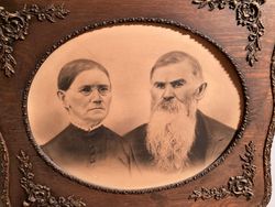

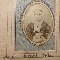
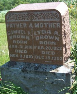
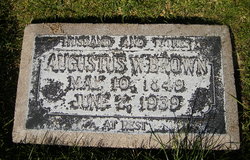
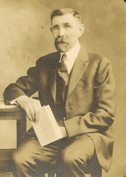
Samuel R. Brown
| Birth | : | 31 Jan 1816 Blount County, Tennessee, USA |
| Death | : | 3 Nov 1910 Davis County, Iowa, USA |
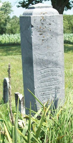
| Burial | : | Highland Cemetery, Wichita, Sedgwick County, USA |
| Coordinate | : | 37.7028008, -97.3007965 |
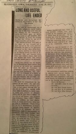
| Description | : | History of Davis County, Iowa - 1882 BROWN, S. R., one of the pioneers of Roscoe, is the subject of this sketch. He was born in Blunt (Blount) county, East Tennessee. When quite young his father, Samuel, who was a son of Thomas Brown, moved to Washington county, Indiana, where Mr. Brown resided about twenty-five years. In 1852 he moved to Henry county, Iowa, and after remaining there two years, in the spring of 1855, he came and settled on his present farm in this county. Mr. Brown was a farmer and received his education in the subscription schools of the early... Read More |
frequently asked questions (FAQ):
-
Where is Samuel R. Brown's memorial?
Samuel R. Brown's memorial is located at: Highland Cemetery, Wichita, Sedgwick County, USA.
-
When did Samuel R. Brown death?
Samuel R. Brown death on 3 Nov 1910 in Davis County, Iowa, USA
-
Where are the coordinates of the Samuel R. Brown's memorial?
Latitude: 37.7028008
Longitude: -97.3007965
Family Members:
Parent
Spouse
Siblings
Children

Flowers:


Nearby Cemetories:
1. Temple Emanuel Cemetery
Wichita, Sedgwick County, USA
Coordinate: 37.7014000, -97.3008000
2. Maple Grove Cemetery
Wichita, Sedgwick County, USA
Coordinate: 37.7036018, -97.2949982
3. Saint James Episcopal Church Columbarium
Wichita, Sedgwick County, USA
Coordinate: 37.6865600, -97.2930000
4. Mission Chapel Mausoleum
Wichita, Sedgwick County, USA
Coordinate: 37.7231200, -97.2955100
5. White Chapel Memorial Gardens
Wichita, Sedgwick County, USA
Coordinate: 37.7162018, -97.2806015
6. East Heights United Methodist Memorial Garden
Wichita, Sedgwick County, USA
Coordinate: 37.6854100, -97.2845500
7. Old Mission Mausoleum
Wichita, Sedgwick County, USA
Coordinate: 37.7242600, -97.2967400
8. Old Mission Cemetery
Wichita, Sedgwick County, USA
Coordinate: 37.7243996, -97.2964020
9. Wichita Hebrew Cemetery
Wichita, Sedgwick County, USA
Coordinate: 37.7201004, -97.2798004
10. Calvary Cemetery
Wichita, Sedgwick County, USA
Coordinate: 37.6781006, -97.2949982
11. Wichita Park Cemetery and Mausoleum
Wichita, Sedgwick County, USA
Coordinate: 37.7277985, -97.2960968
12. Saint Johns Episcopal Church Columbarium
Wichita, Sedgwick County, USA
Coordinate: 37.6918950, -97.3339670
13. Shirley Tilford Memorial Garden
Wichita, Sedgwick County, USA
Coordinate: 37.6942700, -97.3359600
14. Mount Saint Mary Convent Cemetery
Wichita, Sedgwick County, USA
Coordinate: 37.6704000, -97.2904000
15. Saint Stephen's Episcopal Church Columbarium
Wichita, Sedgwick County, USA
Coordinate: 37.6999272, -97.2505590
16. Adorers of The Blood of Christ Convent Cemetery
Wichita, Sedgwick County, USA
Coordinate: 37.6677700, -97.3787800
17. Cornerstone Pentecostal Holiness Church
Wichita, Sedgwick County, USA
Coordinate: 37.6578700, -97.3705700
18. Pierpont Cemetery
Sedgwick County, USA
Coordinate: 37.7011400, -97.2077500
19. Ascension Cemetery
Bel Aire, Sedgwick County, USA
Coordinate: 37.7675018, -97.2533035
20. Greenwich Cemetery
Wichita, Sedgwick County, USA
Coordinate: 37.7518997, -97.2266998
21. Lutheran Cemetery
Wichita, Sedgwick County, USA
Coordinate: 37.7664986, -97.2443008
22. Kensington Gardens Cemetery
Wichita, Sedgwick County, USA
Coordinate: 37.7230988, -97.2040024
23. Lakeview Cemetery & Mausoleum
Wichita, Sedgwick County, USA
Coordinate: 37.7086601, -97.1978989
24. Reflection Pointe Cemetery
Wichita, Sedgwick County, USA
Coordinate: 37.6344800, -97.2264100