
| Birth | : | 3 Apr 1908 Linn Grove, Buena Vista County, Iowa, USA |
| Death | : | 22 Apr 1998 Cherokee, Cherokee County, Iowa, USA |
| Burial | : | Bolivar Cemetery, Bolivar, Denton County, USA |
| Coordinate | : | 33.3582497, -97.2410660 |
| Plot | : | Blk 11, lot 4, grv 12 |
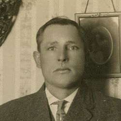
| Description | : | Sanfern Ordell "Sam" Mangold, 90, of Cherokee died Wednesday at the Sioux Valley Hospital in Cherokee following a brief illness. Services will be at 11 a.m. Saturday at Presbyterian Church in Cherokee. Burial will be in Oak Hill Cemetery. Visitation will be from 9 a.m. to 9 p.m. Friday at the Greenwood Funeral Home in Cherokee. |
frequently asked questions (FAQ):
-
Where is Sanfern Ordell “Sam” Mangold's memorial?
Sanfern Ordell “Sam” Mangold's memorial is located at: Bolivar Cemetery, Bolivar, Denton County, USA.
-
When did Sanfern Ordell “Sam” Mangold death?
Sanfern Ordell “Sam” Mangold death on 22 Apr 1998 in Cherokee, Cherokee County, Iowa, USA
-
Where are the coordinates of the Sanfern Ordell “Sam” Mangold's memorial?
Latitude: 33.3582497
Longitude: -97.2410660
Family Members:
Parent
Spouse

Siblings
Flowers:


Nearby Cemetories:
1. Bolivar Cemetery
Bolivar, Denton County, USA
Coordinate: 33.3582497, -97.2410660
2. Knox Cemetery
Denton County, USA
Coordinate: 33.3781013, -97.2667007
3. Duck Creek Cemetery
Sanger, Denton County, USA
Coordinate: 33.3485985, -97.2022018
4. Gober-Wright Cemetery
Denton County, USA
Coordinate: 33.3206070, -97.2044650
5. Sanger Cemetery
Sanger, Denton County, USA
Coordinate: 33.3608017, -97.1603012
6. Blue Mound Cemetery
Sanger, Denton County, USA
Coordinate: 33.2933998, -97.1790009
7. Pollard Cemetery
Denton County, USA
Coordinate: 33.4192009, -97.3230972
8. Plainview Cemetery
Krum, Denton County, USA
Coordinate: 33.2909070, -97.3194810
9. Gribble Springs Cemetery
Sanger, Denton County, USA
Coordinate: 33.3128014, -97.1275024
10. Krum Jackson Cemetery
Krum, Denton County, USA
Coordinate: 33.2449989, -97.2433014
11. Trietsch Family Cemetery
Denton County, USA
Coordinate: 33.3067800, -97.1189700
12. Muslim Cemetery
Krum, Denton County, USA
Coordinate: 33.2399292, -97.3202972
13. Moss Cemetery
Cooke County, USA
Coordinate: 33.4369011, -97.3743973
14. Brier Family Cemetery
Denton County, USA
Coordinate: 33.2226460, -97.2686960
15. Immaculate Conception Catholic Church Columbarium
Denton, Denton County, USA
Coordinate: 33.2374350, -97.1622610
16. Cogburn Cemetery
Leo, Cooke County, USA
Coordinate: 33.4542007, -97.3657990
17. Era Cemetery
Era, Cooke County, USA
Coordinate: 33.5018997, -97.2866974
18. Church of Saint David of Wales Columbarium
Denton, Denton County, USA
Coordinate: 33.2197830, -97.1555770
19. Green Valley Cemetery
Green Valley, Denton County, USA
Coordinate: 33.3112984, -97.0630798
20. Ozment Cemetery
Burns City, Cooke County, USA
Coordinate: 33.5086098, -97.2909012
21. Tyson Cemetery
Pilot Point, Denton County, USA
Coordinate: 33.4160995, -97.0658035
22. Hall Family Farm Cemetery
Ponder, Denton County, USA
Coordinate: 33.2009000, -97.2320900
23. Saint Barnabas Episcopal Church Columbarium
Denton, Denton County, USA
Coordinate: 33.2246750, -97.1331740
24. Davis Cemetery
Denton County, USA
Coordinate: 33.3558006, -97.0477982