
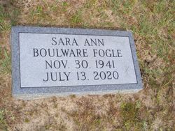

Sara Ann Boulware Fogle
| Birth | : | 30 Nov 1941 Columbia, Richland County, South Carolina, USA |
| Death | : | 13 Jul 2020 West Columbia, Lexington County, South Carolina, USA |
| Burial | : | Trinity Lutheran Church Cemetery, Elloree, Orangeburg County, USA |
| Coordinate | : | 33.5603720, -80.5659850 |
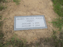
| Description | : | Elloree - Sara Ann Boulware Fogle, 78, died Monday, July 13, 2020, at Lexington Medical Center. Mrs. Fogle was born Nov. 30, 1941, in Columbia. She was the daughter of the late Charlie M. Boulware and the late Carrie Banks Boulware. She was the widow of James Valley Fogle. Mrs. Fogle was a retired state employee with the Department of Parks, Recreation and Tourism. She was a member of Trinity Lutheran Church of Elloree, where she served in many capacities, Red Hat Ladies, Pythian Ladies, United Daughters of the Confederacy, Order of the Eastern Star and Elloree Garden Club. The... Read More |
frequently asked questions (FAQ):
-
Where is Sara Ann Boulware Fogle's memorial?
Sara Ann Boulware Fogle's memorial is located at: Trinity Lutheran Church Cemetery, Elloree, Orangeburg County, USA.
-
When did Sara Ann Boulware Fogle death?
Sara Ann Boulware Fogle death on 13 Jul 2020 in West Columbia, Lexington County, South Carolina, USA
-
Where are the coordinates of the Sara Ann Boulware Fogle's memorial?
Latitude: 33.5603720
Longitude: -80.5659850
Family Members:
Parent
Spouse
Flowers:


Nearby Cemetories:
1. Union AME Church Cemetery
Calhoun County, USA
Coordinate: 33.5840910, -80.5575110
2. Bookhart Cemetery
Elloree, Orangeburg County, USA
Coordinate: 33.5485992, -80.5924988
3. Magrill Family Cemetery
Calhoun County, USA
Coordinate: 33.5601790, -80.5354270
4. Santee First Baptist Cemetery
Elloree, Orangeburg County, USA
Coordinate: 33.5553700, -80.6018080
5. Elloree Hillcrest Cemetery
Elloree, Orangeburg County, USA
Coordinate: 33.5608720, -80.6099720
6. Browning Branch Cemetery
Elloree, Orangeburg County, USA
Coordinate: 33.5231820, -80.5632140
7. New Faith Community Church Cemetery
Elloree, Orangeburg County, USA
Coordinate: 33.5229150, -80.5477570
8. Mount Zion AME Church Cemetery
Creston, Calhoun County, USA
Coordinate: 33.5689940, -80.6151050
9. Jerusalem Cemetery
Elloree, Orangeburg County, USA
Coordinate: 33.5102340, -80.5447570
10. Haynes Chapel AME Church Cemetery
Cameron, Calhoun County, USA
Coordinate: 33.6130110, -80.5751970
11. Mount Hebron Baptist Church Cemetery
Santee, Orangeburg County, USA
Coordinate: 33.5028570, -80.5381980
12. Parlerville A.M.E. Church Cemetery
Santee, Orangeburg County, USA
Coordinate: 33.5208030, -80.5039540
13. Bodrick Cemetery
Lone Star, Calhoun County, USA
Coordinate: 33.6245880, -80.5891440
14. Mount Pisgah Church Cemetery
Santee, Orangeburg County, USA
Coordinate: 33.5182200, -80.5027480
15. Hungerpiller Family Cemetery
Elloree, Orangeburg County, USA
Coordinate: 33.5049010, -80.6123380
16. Cedar Grove Baptist Church Cemetery
Lone Star, Calhoun County, USA
Coordinate: 33.6259320, -80.5947950
17. Hart Graveyard
Holly Hill, Orangeburg County, USA
Coordinate: 33.4918320, -80.5470820
18. Irick Cemetery
Lone Star, Calhoun County, USA
Coordinate: 33.6283580, -80.5924100
19. Smith-Dantzler Cemetery
Elloree, Orangeburg County, USA
Coordinate: 33.4941130, -80.6052520
20. Whitmore, Avinger, Norris, Felder Cemetery
Elloree, Orangeburg County, USA
Coordinate: 33.4870530, -80.5532600
21. Granger Baptist Church Cemetery
Elloree, Orangeburg County, USA
Coordinate: 33.4909840, -80.6030410
22. Gresham Cemetery
Orangeburg County, USA
Coordinate: 33.4906006, -80.6031036
23. Pine Grove Lutheran Church Cemetery
Lone Star, Calhoun County, USA
Coordinate: 33.6349610, -80.6016470
24. McGrew Cemetery
Elloree, Orangeburg County, USA
Coordinate: 33.4859880, -80.6027150