
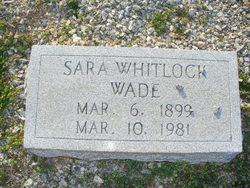
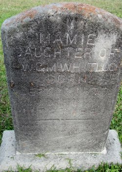
Sara Whitlock Wade
| Birth | : | 6 Mar 1899 Union County, South Carolina, USA |
| Death | : | 10 Mar 1981 |
| Burial | : | St Cuthberts Churchyard, Southport, Metropolitan Borough of Sefton, England |
| Coordinate | : | 53.6603230, -2.9620310 |
frequently asked questions (FAQ):
-
Where is Sara Whitlock Wade's memorial?
Sara Whitlock Wade's memorial is located at: St Cuthberts Churchyard, Southport, Metropolitan Borough of Sefton, England.
-
When did Sara Whitlock Wade death?
Sara Whitlock Wade death on 10 Mar 1981 in
-
Where are the coordinates of the Sara Whitlock Wade's memorial?
Latitude: 53.6603230
Longitude: -2.9620310
Family Members:
Parent

Spouse
Siblings

Flowers:


Nearby Cemetories:
1. St Cuthberts Churchyard
Southport, Metropolitan Borough of Sefton, England
Coordinate: 53.6603230, -2.9620310
2. Emmanuel Parish Church
Southport, Metropolitan Borough of Sefton, England
Coordinate: 53.6604534, -2.9748117
3. Emmanuel Church Garden of Remembrance
North Meols, West Lancashire District, England
Coordinate: 53.6607130, -2.9753420
4. Saint John Crossens Churchyard
Crossens, Metropolitan Borough of Sefton, England
Coordinate: 53.6733410, -2.9478740
5. Holy Trinity Church
Southport, Metropolitan Borough of Sefton, England
Coordinate: 53.6503800, -2.9969150
6. St. Marie on the Sands
Southport, Metropolitan Borough of Sefton, England
Coordinate: 53.6524320, -3.0023440
7. St. Stephen's Churchyard
North Meols, West Lancashire District, England
Coordinate: 53.6813720, -2.9248140
8. Christ Church Churchyard
Southport, Metropolitan Borough of Sefton, England
Coordinate: 53.6327778, -2.9953770
9. Duke Street Cemetery
Southport, Metropolitan Borough of Sefton, England
Coordinate: 53.6343536, -2.9993131
10. Ardwick Cemetery
Ardwick, Metropolitan Borough of Manchester, England
Coordinate: 53.6302778, -2.9900000
11. Southport Crematorium
Scarisbrick, West Lancashire District, England
Coordinate: 53.6235810, -2.9600210
12. St. Mark Churchyard
Scarisbrick, West Lancashire District, England
Coordinate: 53.6134600, -2.9403800
13. St. Elizabeth's Churchyard
Scarisbrick, West Lancashire District, England
Coordinate: 53.6124460, -2.9206340
14. Liverpool Road Cemetery
Birkdale, Metropolitan Borough of Sefton, England
Coordinate: 53.6083620, -3.0257140
15. Sacred Heart RC Cemetery
Birkdale, Metropolitan Borough of Sefton, England
Coordinate: 53.6066100, -3.0270100
16. St. Cuthbert's Churchyard
Halsall, West Lancashire District, England
Coordinate: 53.5852140, -2.9529650
17. St John the Divine
Lytham Saint Annes, Fylde Borough, England
Coordinate: 53.7367060, -2.9548070
18. St. Cuthbert Churchyard
Lytham Saint Annes, Fylde Borough, England
Coordinate: 53.7376560, -2.9761270
19. St. Mary's Churchyard
Tarleton, West Lancashire District, England
Coordinate: 53.6746100, -2.8239200
20. All Saints Churchyard
Hesketh with Becconsall, West Lancashire District, England
Coordinate: 53.7028189, -2.8400142
21. Saltcoates Roman Catholic Cemetery
Lytham Saint Annes, Fylde Borough, England
Coordinate: 53.7463000, -2.9448940
22. West Lancashire Cemetery and Crematorium
Burscough, West Lancashire District, England
Coordinate: 53.5875500, -2.8820300
23. Becconsall Old Church Churchyard
Hesketh with Becconsall, West Lancashire District, England
Coordinate: 53.7023610, -2.8314810
24. St John the Baptist Churchyard
Burscough, West Lancashire District, England
Coordinate: 53.6042760, -2.8401390