Sarah Ann Long Irwin
| Birth | : | 26 Dec 1873 Labette County, Kansas, USA |
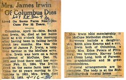
| Death | : | 14 Apr 1958 Columbus, Cherokee County, Kansas, USA |
| Burial | : | Saint Thomas' Cemetery, Carwoola, Queanbeyan–Palerang Regional Council, Australia |
| Coordinate | : | -35.4389480, 149.3827710 |
| Plot | : | Section 7, Row 2, Lot 58 |
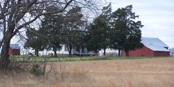
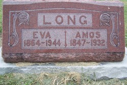
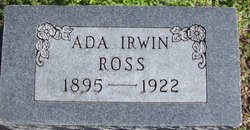
| Description | : | Sarah Ann Long Irwin was born 26 December 1873, at the farm outside of Sheridan, Cherokee, Kansas. She is the daughter of Amos and Delilah F Cox Long. Sarah’s mother died when Sarah was three years old, a month after the birth of her brother Walter. Sarah married James Perry Irwin, 21 Feb 1894, in Cherokee County, Kansas. To this union three children grew to adulthood: Ada France Irwin Ross; Edith Alice Irwin Kerns; and Ivy Amos Irwin. To the family they were lovingly known as Sarie and Perry. |
frequently asked questions (FAQ):
-
Where is Sarah Ann Long Irwin's memorial?
Sarah Ann Long Irwin's memorial is located at: Saint Thomas' Cemetery, Carwoola, Queanbeyan–Palerang Regional Council, Australia.
-
When did Sarah Ann Long Irwin death?
Sarah Ann Long Irwin death on 14 Apr 1958 in Columbus, Cherokee County, Kansas, USA
-
Where are the coordinates of the Sarah Ann Long Irwin's memorial?
Latitude: -35.4389480
Longitude: 149.3827710
Family Members:
Parent
Spouse
Children
Flowers:
Nearby Cemetories:
1. Saint Thomas' Cemetery
Carwoola, Queanbeyan–Palerang Regional Council, Australia
Coordinate: -35.4389480, 149.3827710
2. St Peter & Paul Roman Catholic Cemetery
Hoskinstown, Queanbeyan–Palerang Regional Council, Australia
Coordinate: -35.4229520, 149.4534450
3. Queanbeyan Riverside Cemetery
Queanbeyan, Queanbeyan–Palerang Regional Council, Australia
Coordinate: -35.3440470, 149.2353160
4. Oaks Burial Ground
Australian Capital Territory, Australia
Coordinate: -35.3401810, 149.2267220
5. Queanbeyan Lawn Cemetery & Memorial Gardens
Queanbeyan, Queanbeyan–Palerang Regional Council, Australia
Coordinate: -35.3692199, 149.2021252
6. Captain's Flat Cemetery
Captains Flat, Queanbeyan–Palerang Regional Council, Australia
Coordinate: -35.6124200, 149.4589850
7. Bungendore Cemetery
Bungendore, Queanbeyan–Palerang Regional Council, Australia
Coordinate: -35.2590741, 149.4526073
8. Turalla Cemetery
Bungendore, Queanbeyan–Palerang Regional Council, Australia
Coordinate: -35.2419090, 149.4080250
9. Duntroon Military College Grounds
Duntroon, Canberra, Australia
Coordinate: -35.2997220, 149.1650000
10. Saint Christopher's Cathedral
Forrest, Canberra, Australia
Coordinate: -35.3189500, 149.1316790
11. National Police Memorial
Parkes, Canberra, Australia
Coordinate: -35.2992092, 149.1441029
12. Australian War Memorial
Campbell, Canberra, Australia
Coordinate: -35.2805000, 149.1491000
13. St John the Baptist Cemetery
Reid, Canberra, Australia
Coordinate: -35.2876800, 149.1412900
14. Woden Cemetery
Phillip, Canberra, Australia
Coordinate: -35.3426437, 149.0932770
15. De Salis Cuppacumbalong Homestead Cuppacumbalong
Australian Capital Territory, Australia
Coordinate: -35.5197700, 149.0748200
16. De Salis Cemetery
Tharwa, Australian Capital Territory, Australia
Coordinate: -35.5197548, 149.0747517
17. Tharwa Cemetery
Tharwa, Australian Capital Territory, Australia
Coordinate: -35.4964739, 149.0610437
18. Norwood Park Crematorium
Mitchell, Canberra, Australia
Coordinate: -35.2200070, 149.1332390
19. Gungahlin Cemetery
Mitchell, Canberra, Australia
Coordinate: -35.2145856, 149.1371241
20. Majors Creek Cemetery
Majors Creek, Queanbeyan–Palerang Regional Council, Australia
Coordinate: -35.5804770, 149.7281970
21. Braidwood Lawn Cemetery
Braidwood, Queanbeyan–Palerang Regional Council, Australia
Coordinate: -35.4491000, 149.7966000
22. Braidwood Cemetery
Braidwood, Queanbeyan–Palerang Regional Council, Australia
Coordinate: -35.4505750, 149.7967550
23. Charleyong Cemetery
Charleyong, Queanbeyan–Palerang Regional Council, Australia
Coordinate: -35.4500740, 149.7970560
24. Old Weetangera Methodist Cemetery
Hawker, Canberra, Australia
Coordinate: -35.2483534, 149.0381581


