

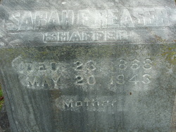
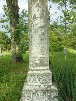
Sarah Elizabeth “Lizzie” Hoops Shaffer
| Birth | : | 23 Dec 1868 Kentucky, USA |
| Death | : | 20 May 1943 Birch Tree, Shannon County, Missouri, USA |
| Burial | : | Foothills Gardens of Memory, Longmont, Boulder County, USA |
| Coordinate | : | 40.2332993, -105.1027985 |
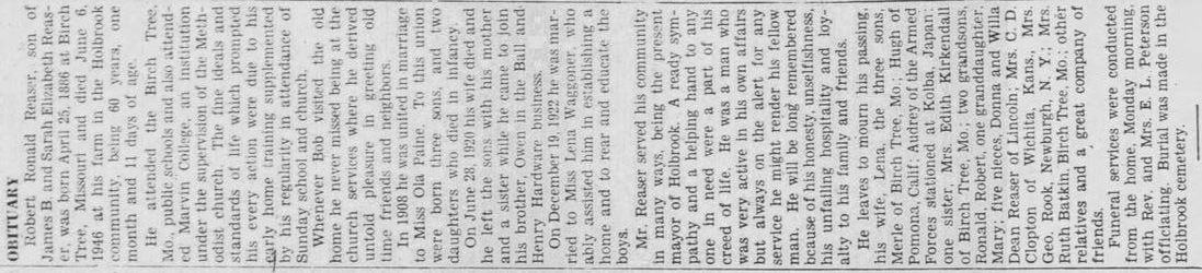
| Description | : | Full name: Sarah Elizabeth Hoops Reaser Shaffer. Daughter of Henry Hoops & Mary Hawes who married on Mar 12, 1868 in Ohio County, Kentucky. Husbands: 1)James Reaser, married Dec 25, 1885, Shannon Co., MO 2) Theodore V. Shaffer ca 1925. ************************************************************ Henry Hoops in the 1870 United States Federal Census Name: Henry Hoops Age in 1870: 27 Birth Date: abt 1843 Birthplace: Kentucky Dwelling Number: 269 Home in 1870: Cromwell, Ohio, Kentucky Race: White Gender: Male Post Office: Hartford Occupation: Farmer Father of Foreign Birth: Yes Male Citizen Over 21: Yes Personal Estate Value: 500 |
frequently asked questions (FAQ):
-
Where is Sarah Elizabeth “Lizzie” Hoops Shaffer's memorial?
Sarah Elizabeth “Lizzie” Hoops Shaffer's memorial is located at: Foothills Gardens of Memory, Longmont, Boulder County, USA.
-
When did Sarah Elizabeth “Lizzie” Hoops Shaffer death?
Sarah Elizabeth “Lizzie” Hoops Shaffer death on 20 May 1943 in Birch Tree, Shannon County, Missouri, USA
-
Where are the coordinates of the Sarah Elizabeth “Lizzie” Hoops Shaffer's memorial?
Latitude: 40.2332993
Longitude: -105.1027985
Family Members:
Parent
Spouse
Siblings
Children
Flowers:

Left by Anonymous on 03 Feb 2010

Dearest Grandma Shaffer thank you for taking in and loving my grandpa when he lost his mother. You taught him so much and in turn he took me in, his granddaughter, at 2y. and loved me with all his heart and taught me so much. I am forever grateful.
Left by Anonymous on 02 Sep 2013

Left by Anonymous on 14 Aug 2021

Left by Anonymous on 20 Sep 2021


Nearby Cemetories:
1. Foothills Gardens of Memory
Longmont, Boulder County, USA
Coordinate: 40.2332993, -105.1027985
2. Faith Community Lutheran Columbarium
Longmont, Boulder County, USA
Coordinate: 40.2040400, -105.1228300
3. Bethlehem Lutheran Church Columbarium
Longmont, Boulder County, USA
Coordinate: 40.1856100, -105.1079700
4. Mountain View Cemetery
Longmont, Boulder County, USA
Coordinate: 40.1794014, -105.1038971
5. Highlandlake Pioneer Cemetery
Mead, Weld County, USA
Coordinate: 40.2473000, -105.0264800
6. Hygiene Cemetery
Hygiene, Boulder County, USA
Coordinate: 40.1894302, -105.1688766
7. Parrish Ranch Cemetery
Berthoud, Larimer County, USA
Coordinate: 40.2634240, -105.2004540
8. Greenlawn Cemetery
Berthoud, Larimer County, USA
Coordinate: 40.3064003, -105.0556030
9. Saint Stephens Episcopal Church Columbarium
Longmont, Boulder County, USA
Coordinate: 40.1433000, -105.1070000
10. Burlington Cemetery
Longmont, Boulder County, USA
Coordinate: 40.1417007, -105.1200027
11. Pratt Cemetery
Longmont, Boulder County, USA
Coordinate: 40.1419000, -105.1221000
12. Weisner Cemetery
Longmont, Boulder County, USA
Coordinate: 40.2028000, -105.2436000
13. Ryssby Cemetery
Longmont, Boulder County, USA
Coordinate: 40.1396190, -105.2055190
14. Pleasantview Ridge Cemetery
Weld County, USA
Coordinate: 40.1166115, -105.0551834
15. Lyons Cemetery
Lyons, Boulder County, USA
Coordinate: 40.2296000, -105.2678000
16. Niwot Cemetery
Niwot, Boulder County, USA
Coordinate: 40.1130981, -105.1847000
17. Good Samaritan Circle of Life Memory Gardens
Loveland, Larimer County, USA
Coordinate: 40.3688000, -105.0826000
18. Burbridge Cemetery
Gowanda, Weld County, USA
Coordinate: 40.1761500, -104.9101000
19. Johnstown Cemetery
Elwell, Weld County, USA
Coordinate: 40.3381004, -104.9439011
20. First United Methodist Church Columbarium
Loveland, Larimer County, USA
Coordinate: 40.3973310, -105.0797360
21. Modena Cemetery
Larimer County, USA
Coordinate: 40.3994000, -105.1233000
22. Lakeside Cemetery
Loveland, Larimer County, USA
Coordinate: 40.4118996, -105.0710983
23. Loveland Burial Park
Loveland, Larimer County, USA
Coordinate: 40.4126244, -105.0751648
24. Mountain View Presbyterian Church Columbarium
Loveland, Larimer County, USA
Coordinate: 40.4186000, -105.0772000