
| Birth | : | 14 Sep 1842 Hardin County, Ohio, USA |
| Death | : | 21 Sep 1922 Weeping Water, Cass County, Nebraska, USA |
| Burial | : | Six Mile Grove Cemetery, Lyle, Mower County, USA |
| Coordinate | : | 43.5069389, -92.8836136 |
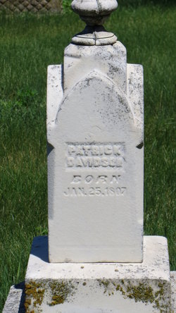
| Description | : | Sarah Matilda was the daughter of Patrick and Elizabeth (Mathews) Davidson. She was born 14 Sept. 1842 near Kenton, Hardin Co., Ohio. She died 21 Sept. 1923, Homestead, Dakota Co., Nebraska. Both are buried in East View Cemetery, Allen, Nebraska. Hezekiah Hiatt Way was the son of Paul and Lavina (Hiatt) Way. He was born 29 Nov 1828, Wayne Co., Indiana. He married 16 Jan 1861 at Weeping Water, Cass Co., Nebraska, Sarah Matilda Davidson. Hezekiah died 16 Jan. 1861, Weepiing Water, Cass Co., Nebraska. In the 1910 and 1920 censuses, Sarah is listed as widowed, living with her son, Frank. Children: Elizabeth Lavina Anna... Read More |
frequently asked questions (FAQ):
-
Where is Sarah Matilda Davidson Way's memorial?
Sarah Matilda Davidson Way's memorial is located at: Six Mile Grove Cemetery, Lyle, Mower County, USA.
-
When did Sarah Matilda Davidson Way death?
Sarah Matilda Davidson Way death on 21 Sep 1922 in Weeping Water, Cass County, Nebraska, USA
-
Where are the coordinates of the Sarah Matilda Davidson Way's memorial?
Latitude: 43.5069389
Longitude: -92.8836136
Family Members:
Parent
Spouse

Siblings
Children
Flowers:


Nearby Cemetories:
1. Mona Cemetery
Mona, Mitchell County, USA
Coordinate: 43.4824982, -92.9402771
2. Pleasant Hill Cemetery
Mona, Mitchell County, USA
Coordinate: 43.4768982, -92.9467010
3. Union Township Cemetery
Toeterville, Mitchell County, USA
Coordinate: 43.4578018, -92.8491974
4. Union Presbyterian Cemetery
Stacyville, Mitchell County, USA
Coordinate: 43.4797211, -92.8088913
5. Rustad Cemetery
Otranto, Mitchell County, USA
Coordinate: 43.4585991, -92.9400024
6. Saint Peter Cemetery
Toeterville, Mitchell County, USA
Coordinate: 43.4402809, -92.8897171
7. Saint Johns Cemetery
Johnsburg, Mower County, USA
Coordinate: 43.5055618, -92.7688904
8. Woodbury Cemetery
Lyle, Mower County, USA
Coordinate: 43.5071983, -93.0083008
9. Ogden Cemetery
Otranto, Mitchell County, USA
Coordinate: 43.4366989, -92.9681015
10. Visitation Catholic Cemetery
Stacyville, Mitchell County, USA
Coordinate: 43.4430618, -92.7813873
11. Saint Peters Cemetery
Rose Creek, Mower County, USA
Coordinate: 43.6019402, -92.8375015
12. Stacyville Cemetery
Stacyville, Mitchell County, USA
Coordinate: 43.4294014, -92.7908020
13. Prairie View Cemetery
Rose Creek, Mower County, USA
Coordinate: 43.6085815, -92.8261871
14. Little Cedar Cemetery
Adams, Mower County, USA
Coordinate: 43.5736008, -92.7574997
15. Rose Creek Cemetery
Varco, Mower County, USA
Coordinate: 43.6164017, -92.9452972
16. McKinley Cemetery
Saint Ansgar, Mitchell County, USA
Coordinate: 43.3906400, -92.9368300
17. Cedar City Cemetery
Austin, Mower County, USA
Coordinate: 43.5872100, -93.0132500
18. First Lutheran Cemetery
Saint Ansgar, Mitchell County, USA
Coordinate: 43.3841705, -92.9194412
19. Deer Creek Lutheran Church Cemetery
Carpenter, Mitchell County, USA
Coordinate: 43.4297218, -93.0236130
20. Newburg Cemetery
Carpenter, Mitchell County, USA
Coordinate: 43.4143982, -93.0049973
21. Sacred Heart Cemetery
Adams, Mower County, USA
Coordinate: 43.5635986, -92.7221985
22. Saint Ansgar Cemetery
Saint Ansgar, Mitchell County, USA
Coordinate: 43.3777809, -92.9094391
23. Grandview Cemetery
Austin, Mower County, USA
Coordinate: 43.6333008, -92.9505997
24. Priem Cemetery
Carpenter, Mitchell County, USA
Coordinate: 43.3869019, -92.9747009