
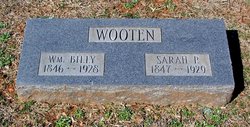

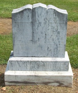
Sarah Matilda Presley Wooten
| Birth | : | 11 Mar 1847 Union County, North Carolina, USA |
| Death | : | 6 Jan 1929 Indian Trail, Union County, North Carolina, USA |
| Burial | : | Beechwoods Cemetery, Falls Creek, Jefferson County, USA |
| Coordinate | : | 41.1794014, -78.8617020 |
| Description | : | Daughter of Eli and Polly Presley-Married William E Wooten in Union County NC March 9, 1873 |
frequently asked questions (FAQ):
-
Where is Sarah Matilda Presley Wooten's memorial?
Sarah Matilda Presley Wooten's memorial is located at: Beechwoods Cemetery, Falls Creek, Jefferson County, USA.
-
When did Sarah Matilda Presley Wooten death?
Sarah Matilda Presley Wooten death on 6 Jan 1929 in Indian Trail, Union County, North Carolina, USA
-
Where are the coordinates of the Sarah Matilda Presley Wooten's memorial?
Latitude: 41.1794014
Longitude: -78.8617020
Family Members:
Parent

Spouse

Siblings
Children
Flowers:


Nearby Cemetories:
1. Beechwoods Cemetery
Falls Creek, Jefferson County, USA
Coordinate: 41.1794014, -78.8617020
2. Beechtree Cemetery
Brockway, Jefferson County, USA
Coordinate: 41.2164497, -78.8231354
3. Taylor Cemetery
Falls Creek, Jefferson County, USA
Coordinate: 41.1409683, -78.8108292
4. Sandy Valley Cemetery
Sandy Valley, Jefferson County, USA
Coordinate: 41.1261000, -78.8779000
5. Smith Cemetery
Reynoldsville, Jefferson County, USA
Coordinate: 41.1331596, -78.9114456
6. Sugar Hill Cemetery
Brockway, Jefferson County, USA
Coordinate: 41.2480000, -78.8581000
7. Hazen Amish Community Cemetery
Hazen, Jefferson County, USA
Coordinate: 41.2344400, -78.9196200
8. Saint Mary's Catholic Cemetery
Reynoldsville, Jefferson County, USA
Coordinate: 41.1078950, -78.8875100
9. Temple Cemetery
Hazen, Jefferson County, USA
Coordinate: 41.2180000, -78.9469000
10. Wildwood Cemetery
Brockway, Jefferson County, USA
Coordinate: 41.2419014, -78.7994003
11. Saint Michaels Cemetery
DuBois, Clearfield County, USA
Coordinate: 41.1227989, -78.7855988
12. Saint Josephs Cemetery
DuBois, Clearfield County, USA
Coordinate: 41.1227989, -78.7822037
13. Sons of Israel Cemetery
DuBois, Clearfield County, USA
Coordinate: 41.1228250, -78.7792960
14. Saint Catherine Cemetery
DuBois, Clearfield County, USA
Coordinate: 41.1218987, -78.7782974
15. Beulah Land Cemetery
Reynoldsville, Jefferson County, USA
Coordinate: 41.0931015, -78.8743973
16. Wayne Cemetery
Sandy Township, Clearfield County, USA
Coordinate: 41.1068860, -78.7934230
17. Greenwood Cemetery
DuBois, Clearfield County, USA
Coordinate: 41.1502991, -78.7485962
18. Baptist Cemetery
Winslow Township, Jefferson County, USA
Coordinate: 41.0897484, -78.8731155
19. Rumbarger Cemetery
DuBois, Clearfield County, USA
Coordinate: 41.1157990, -78.7742004
20. Fuller Cemetery
Reynoldsville, Jefferson County, USA
Coordinate: 41.0867120, -78.8582660
21. Saint Tobias Cemetery
Brockway, Jefferson County, USA
Coordinate: 41.2546997, -78.7817001
22. John DuBois Monument
DuBois, Clearfield County, USA
Coordinate: 41.1288240, -78.7515390
23. Prospect Cemetery
Reynoldsville, Jefferson County, USA
Coordinate: 41.0839005, -78.8377991
24. Reynoldsville Cemetery
Reynoldsville, Jefferson County, USA
Coordinate: 41.0829000, -78.8940000