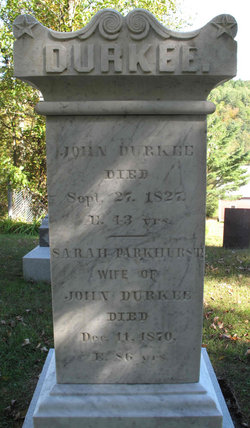
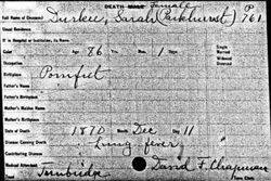
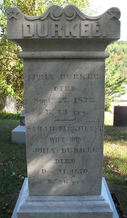
Sarah Parkhurst Durkee
| Birth | : | 10 Dec 1785 Pomfret, Windham County, Connecticut, USA |
| Death | : | 11 Dec 1870 Tunbridge, Orange County, Vermont, USA |
| Burial | : | Zion Presbyterian Cemetery, Furrs, Pontotoc County, USA |
| Coordinate | : | 34.2356682, -88.8344269 |
| Description | : | ae. 86 yrs |
frequently asked questions (FAQ):
-
Where is Sarah Parkhurst Durkee's memorial?
Sarah Parkhurst Durkee's memorial is located at: Zion Presbyterian Cemetery, Furrs, Pontotoc County, USA.
-
When did Sarah Parkhurst Durkee death?
Sarah Parkhurst Durkee death on 11 Dec 1870 in Tunbridge, Orange County, Vermont, USA
-
Where are the coordinates of the Sarah Parkhurst Durkee's memorial?
Latitude: 34.2356682
Longitude: -88.8344269
Family Members:
Parent
Spouse
Siblings
Children
Nearby Cemetories:
1. Zion Presbyterian Cemetery
Furrs, Pontotoc County, USA
Coordinate: 34.2356682, -88.8344269
2. Big Hill Cemetery
Tupelo, Lee County, USA
Coordinate: 34.2478000, -88.8244000
3. New Zion Cemetery
Furrs, Pontotoc County, USA
Coordinate: 34.2500000, -88.8452988
4. Furrs Cemetery
Furrs, Pontotoc County, USA
Coordinate: 34.2390785, -88.8550034
5. Oasis of Love Cemetery
Furrs, Pontotoc County, USA
Coordinate: 34.2189970, -88.8420470
6. Westmoreland Cemetery
Lee County, USA
Coordinate: 34.2352982, -88.7878036
7. College Hill Cemetery
Pontotoc County, USA
Coordinate: 34.2344017, -88.8867035
8. Chapel Grove Cemetery
Chesterville, Pontotoc County, USA
Coordinate: 34.2766080, -88.8540910
9. Valley Grove Cemetery
Zion, Pontotoc County, USA
Coordinate: 34.1922050, -88.8504390
10. Bass Cemetery
Pontotoc County, USA
Coordinate: 34.1918983, -88.8503036
11. Zion Cemetery
Zion, Pontotoc County, USA
Coordinate: 34.2056980, -88.8799100
12. Palmetto Cemetery
Palmetto, Lee County, USA
Coordinate: 34.1921997, -88.7983017
13. Palmetto CME Church Cemetery
Verona, Lee County, USA
Coordinate: 34.1844230, -88.8163090
14. Chesterville Memorial Cemetery
Lee County, USA
Coordinate: 34.2888060, -88.8247530
15. Old Chesterville Cemetery
Chesterville, Pontotoc County, USA
Coordinate: 34.2959770, -88.8288830
16. Philips Cemetery
Lee County, USA
Coordinate: 34.2449989, -88.7605972
17. Mount Pleasant Chesterville MB Church Cemetery
Tupelo, Lee County, USA
Coordinate: 34.2975000, -88.8252800
18. Maxcy Cemetery
Belden, Lee County, USA
Coordinate: 34.3003000, -88.8236000
19. Allens Cemetery
Lee County, USA
Coordinate: 34.2277985, -88.7546997
20. Saint Paul Methodist Church Cemetery
Belden, Lee County, USA
Coordinate: 34.3016860, -88.8251220
21. Spring Hill Cemetery
Pontotoc County, USA
Coordinate: 34.2658005, -88.9119034
22. Longview Cemetery
Pontotoc County, USA
Coordinate: 34.2870497, -88.8947810
23. Kimble Chapel Cemetery
Belden, Lee County, USA
Coordinate: 34.3036370, -88.7915470
24. Mallory-Ellis Cemetery
Palmetto, Lee County, USA
Coordinate: 34.1853000, -88.7639000

