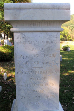
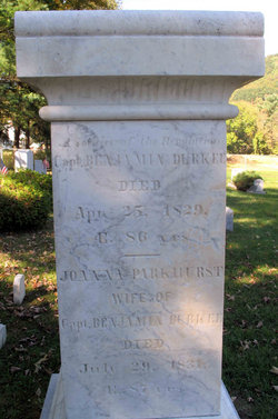
Joanna Sabin Parkhurst Durkee
| Birth | : | 18 Aug 1744 Pomfret, Windham County, Connecticut, USA |
| Death | : | 29 Jul 1831 |
| Burial | : | St. Luke's Churchyard, Farnworth, Halton Unitary Authority, England |
| Coordinate | : | 53.3843810, -2.7271840 |
| Description | : | First Married Darius Parkhurst in 1776 and then second Capt Benjamin Durkee inscription: Wife of Capt. Benjamin Durkee ae. 87 |
frequently asked questions (FAQ):
-
Where is Joanna Sabin Parkhurst Durkee's memorial?
Joanna Sabin Parkhurst Durkee's memorial is located at: St. Luke's Churchyard, Farnworth, Halton Unitary Authority, England.
-
When did Joanna Sabin Parkhurst Durkee death?
Joanna Sabin Parkhurst Durkee death on 29 Jul 1831 in
-
Where are the coordinates of the Joanna Sabin Parkhurst Durkee's memorial?
Latitude: 53.3843810
Longitude: -2.7271840
Family Members:
Spouse
Children
Nearby Cemetories:
1. St. Luke's Churchyard
Farnworth, Halton Unitary Authority, England
Coordinate: 53.3843810, -2.7271840
2. Widnes Cemetery
Widnes, Halton Unitary Authority, England
Coordinate: 53.3803470, -2.7326050
3. St Bartholomew's Churchyard
Rainhill, Metropolitan Borough of St Helens, England
Coordinate: 53.4076231, -2.7513287
4. St Ann’s Graveyard
Rainhill, Metropolitan Borough of St Helens, England
Coordinate: 53.4157487, -2.7638276
5. All Saints Churchyard
Runcorn, Halton Unitary Authority, England
Coordinate: 53.3434070, -2.7366030
6. Knowsley Cemetery
Knowsley, Metropolitan Borough of Knowsley, England
Coordinate: 53.4083240, -2.7847870
7. Penketh Quaker Meeting House
Penketh, Warrington Unitary Authority, England
Coordinate: 53.3873500, -2.6555300
8. St Nicholas Churchyard
St Helens, Metropolitan Borough of St Helens, England
Coordinate: 53.4284660, -2.7213830
9. St. Mary's Cemetery
Great Sankey, Warrington Unitary Authority, England
Coordinate: 53.3885690, -2.6507810
10. St. Mary's Churchyard
Great Sankey, Warrington Unitary Authority, England
Coordinate: 53.3912000, -2.6497000
11. Runcorn Cemetery
Runcorn, Halton Unitary Authority, England
Coordinate: 53.3368050, -2.7354150
12. St. Anne and Blessed Dominic Churchyard
St Helens, Metropolitan Borough of St Helens, England
Coordinate: 53.4330960, -2.7083700
13. St. Nicholas' Churchyard
Whiston, Metropolitan Borough of Knowsley, England
Coordinate: 53.4069736, -2.8028920
14. Norton Priory
Norton, Halton Unitary Authority, England
Coordinate: 53.3424120, -2.6796450
15. Halton Cemetery
Runcorn, Halton Unitary Authority, England
Coordinate: 53.3283800, -2.6943340
16. St. Nicholas Churchyard
Halewood, Metropolitan Borough of Knowsley, England
Coordinate: 53.3694400, -2.8284900
17. Prescot Cemetery
Prescot, Metropolitan Borough of Knowsley, England
Coordinate: 53.4266620, -2.8081590
18. St. Mary the Virgin Churchyard
Prescot, Metropolitan Borough of Knowsley, England
Coordinate: 53.4284600, -2.8067000
19. St. Mary's Churchyard
Hale, Halton Unitary Authority, England
Coordinate: 53.3325900, -2.7952900
20. St. Agnes Roman Catholic
Huyton with Roby, Metropolitan Borough of Knowsley, England
Coordinate: 53.4090600, -2.8320100
21. Friends Meeting House, Hardshaw, St Helens
St Helens, Metropolitan Borough of St Helens, England
Coordinate: 53.4518340, -2.7320414
22. St. Barnabas Churchyard
Warrington Unitary Authority, England
Coordinate: 53.3920038, -2.6121106
23. St Peter's of Parr Churchyard
Parr, Metropolitan Borough of St Helens, England
Coordinate: 53.4543745, -2.7009772
24. All Saints Churchyard
Daresbury, Halton Unitary Authority, England
Coordinate: 53.3405457, -2.6313031


