
Sarah Pond Lealand
| Birth | : | 8 Nov 1763 Wrentham, Norfolk County, Massachusetts, USA |
| Death | : | 4 Jul 1820 Holliston, Middlesex County, Massachusetts, USA |
| Burial | : | Bath Abbey, Bath, Bath and North East Somerset Unitary Authority, England |
| Coordinate | : | 51.3815310, -2.3586640 |
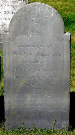
| Inscription | : | In memory of MRS. SARAH LEALAND late wife of MR. JEREMIAH LEALAND who died July 4th 1820 Aged 57 years. Beneath this sod a mother's ashes sleep Around this grave her sorrowing children weep But |
| Description | : | Wrentham births: POND, Sarah, d. of Timothy Jr. and Sarah, Nov. 8, 1763. Medway marriage: POND, Sarah (int. adds Mrs.) of Franklin and Ichabod Hawes (int. adds Haws), Feb. 14, 1782. Holliston marriages: LEALAND, Jeremiah and Sarah Hawes of Franklin, int. Sept. 9, 1797. Holliston deaths: LELAND, Sarah, wid. Jeremiah, July 4, 1820. [consumption, Aug. 4, a. 68. CR1] [Lealand, July 4, a. 57. GR1] |
frequently asked questions (FAQ):
-
Where is Sarah Pond Lealand's memorial?
Sarah Pond Lealand's memorial is located at: Bath Abbey, Bath, Bath and North East Somerset Unitary Authority, England.
-
When did Sarah Pond Lealand death?
Sarah Pond Lealand death on 4 Jul 1820 in Holliston, Middlesex County, Massachusetts, USA
-
Where are the coordinates of the Sarah Pond Lealand's memorial?
Latitude: 51.3815310
Longitude: -2.3586640
Family Members:
Parent

Spouse
Siblings
Children
Flowers:


Nearby Cemetories:
1. Bath Abbey
Bath, Bath and North East Somerset Unitary Authority, England
Coordinate: 51.3815310, -2.3586640
2. St. Mary de Stall Churchyard (Defunct)
Bath, Bath and North East Somerset Unitary Authority, England
Coordinate: 51.3813350, -2.3600353
3. Quaker Meeting House
Bath, Bath and North East Somerset Unitary Authority, England
Coordinate: 51.3823280, -2.3604380
4. Old Orchard Street Catholic Burial Vault
Bath, Bath and North East Somerset Unitary Authority, England
Coordinate: 51.3800370, -2.3579910
5. Bath General Hospital Burial Ground
Bath and North East Somerset Unitary Authority, England
Coordinate: 51.3824715, -2.3614742
6. Ss Michael & Paul Churchyard
Bath, Bath and North East Somerset Unitary Authority, England
Coordinate: 51.3834970, -2.3596980
7. St James Old Burial Ground
Bath, Bath and North East Somerset Unitary Authority, England
Coordinate: 51.3798600, -2.3610100
8. St. Michael's Burial Ground
Bath, Bath and North East Somerset Unitary Authority, England
Coordinate: 51.3838810, -2.3594090
9. St Mary's Chapel, Queens Square
Bath, Bath and North East Somerset Unitary Authority, England
Coordinate: 51.3827790, -2.3649790
10. Saint Mark's Churchyard
Widcombe, Bath and North East Somerset Unitary Authority, England
Coordinate: 51.3766660, -2.3588010
11. Baptist Burial Ground
Widcombe, Bath and North East Somerset Unitary Authority, England
Coordinate: 51.3764216, -2.3556947
12. St Mary Magdalen Chapel
Widcombe, Bath and North East Somerset Unitary Authority, England
Coordinate: 51.3760486, -2.3643405
13. Old Baptist Burial Ground
Walcot, Bath and North East Somerset Unitary Authority, England
Coordinate: 51.3755070, -2.3544360
14. St. Mary's Churchyard
Bathwick, Bath and North East Somerset Unitary Authority, England
Coordinate: 51.3876120, -2.3543540
15. Abbey & St James' Graveyard for the Poor
Widcombe, Bath and North East Somerset Unitary Authority, England
Coordinate: 51.3753550, -2.3545640
16. St. Swithin Churchyard
Bath, Bath and North East Somerset Unitary Authority, England
Coordinate: 51.3885480, -2.3594500
17. St. John the Baptist Churchyard
Bathwick, Bath and North East Somerset Unitary Authority, England
Coordinate: 51.3886890, -2.3547030
18. Walcot Methodist Chapel Burial Ground
Bath, Bath and North East Somerset Unitary Authority, England
Coordinate: 51.3897080, -2.3579610
19. St. James' Cemetery
Bath, Bath and North East Somerset Unitary Authority, England
Coordinate: 51.3802000, -2.3722200
20. Quaker Burial Ground
Widcombe, Bath and North East Somerset Unitary Authority, England
Coordinate: 51.3744350, -2.3498460
21. St Thomas à Becket's Church
Widcombe, Bath and North East Somerset Unitary Authority, England
Coordinate: 51.3734250, -2.3465560
22. Smallcombe Vale Cemetery
Bathwick, Bath and North East Somerset Unitary Authority, England
Coordinate: 51.3757400, -2.3429400
23. Independent Burial Ground Argyle Chapel
Bath, Bath and North East Somerset Unitary Authority, England
Coordinate: 51.3925420, -2.3536920
24. Unitarian Chapel Burial Ground
Widcombe, Bath and North East Somerset Unitary Authority, England
Coordinate: 51.3704650, -2.3539270