
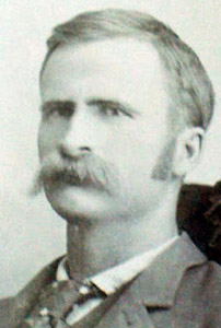

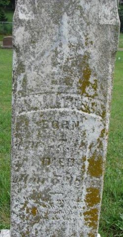
Seliam Mattison
| Birth | : | 13 Dec 1858 Newton, Jasper County, Iowa, USA |
| Death | : | 1909 Ponca, Dixon County, Nebraska, USA |
| Burial | : | Edge Hill Cemetery, Charles Town, Jefferson County, USA |
| Coordinate | : | 39.2882800, -77.8510500 |
| Description | : | Married C. Eldora Beller on 19 Mar 1892. City Engineer of Ponca, Neb., dropped dead in the pumping station of the city, recently; he was 50 years old and had been a resident of Ponca for many years. - Municipal journal and engineer, volume 26. |
frequently asked questions (FAQ):
-
Where is Seliam Mattison's memorial?
Seliam Mattison's memorial is located at: Edge Hill Cemetery, Charles Town, Jefferson County, USA.
-
When did Seliam Mattison death?
Seliam Mattison death on 1909 in Ponca, Dixon County, Nebraska, USA
-
Where are the coordinates of the Seliam Mattison's memorial?
Latitude: 39.2882800
Longitude: -77.8510500
Family Members:
Parent
Spouse
Siblings

Children

Flowers:


Nearby Cemetories:
1. Edge Hill Cemetery
Charles Town, Jefferson County, USA
Coordinate: 39.2882800, -77.8510500
2. Zion Episcopal Churchyard
Charles Town, Jefferson County, USA
Coordinate: 39.2890400, -77.8566600
3. Robert Rutherford Gravesite
Charles Town, Jefferson County, USA
Coordinate: 39.2938499, -77.8452835
4. Asbury United Methodist Church Cemetery
Charles Town, Jefferson County, USA
Coordinate: 39.2905350, -77.8620834
5. Fairview Cemetery
Gibsontown, Jefferson County, USA
Coordinate: 39.2695650, -77.8756210
6. Peter K. Johnson Farm Graveyard
Charles Town, Jefferson County, USA
Coordinate: 39.2617536, -77.9051369
7. Washington Burial Ground
Charles Town, Jefferson County, USA
Coordinate: 39.3020379, -77.9163828
8. Quaker Cemetery
Charles Town, Jefferson County, USA
Coordinate: 39.2442586, -77.9017906
9. Saint Andrews on the Mount Episcopal Churchyard
Mountain Mission, Jefferson County, USA
Coordinate: 39.2459970, -77.7967710
10. Murrill Hill United Methodist Church Cemetery
Mountain Mission, Jefferson County, USA
Coordinate: 39.2472900, -77.7950300
11. Johnsontown Cemetery
Johnsontown, Jefferson County, USA
Coordinate: 39.3404200, -77.8910700
12. Payne's Hill Cemetery
Halltown, Jefferson County, USA
Coordinate: 39.3190730, -77.7810570
13. Poor Farm Cemetery
Kearneysville, Jefferson County, USA
Coordinate: 39.3345590, -77.9094350
14. Allstadt Graveyard
Halltown, Jefferson County, USA
Coordinate: 39.3145270, -77.7732030
15. Chestnut Hill United Methodist Church Cemetery
Harpers Ferry, Jefferson County, USA
Coordinate: 39.2714800, -77.7681500
16. Moler Graveyard
Halltown, Jefferson County, USA
Coordinate: 39.3188400, -77.7739900
17. Kabletown Churchyard
Kabletown, Jefferson County, USA
Coordinate: 39.2215881, -77.8597183
18. Lock Family Cemetery
Wheatland, Jefferson County, USA
Coordinate: 39.2273780, -77.8872300
19. Darke-Engle-Ronemous Cemetery
Shenandoah Junction, Jefferson County, USA
Coordinate: 39.3544250, -77.8314400
20. Grove Cemetery
Keyes Ferry Acres, Jefferson County, USA
Coordinate: 39.2741014, -77.7644080
21. Mount Zion AME Church Cemetery
Reedson, Jefferson County, USA
Coordinate: 39.3492120, -77.8001050
22. New Hopewell Cemetery
Kearneysville, Jefferson County, USA
Coordinate: 39.3520000, -77.8990000
23. Willow View Blackford Slave Cemetery
Kearneysville, Jefferson County, USA
Coordinate: 39.3607854, -77.8725668
24. Silver Grove Cemetery
Harpers Ferry, Jefferson County, USA
Coordinate: 39.2962044, -77.7552686